SUMMARY
This is AI generated summarization, which may have errors. For context, always refer to the full article.
What’s the weather like in your area? Report the situation through Rappler’s Agos or tweet us at @rapplerdotcom.
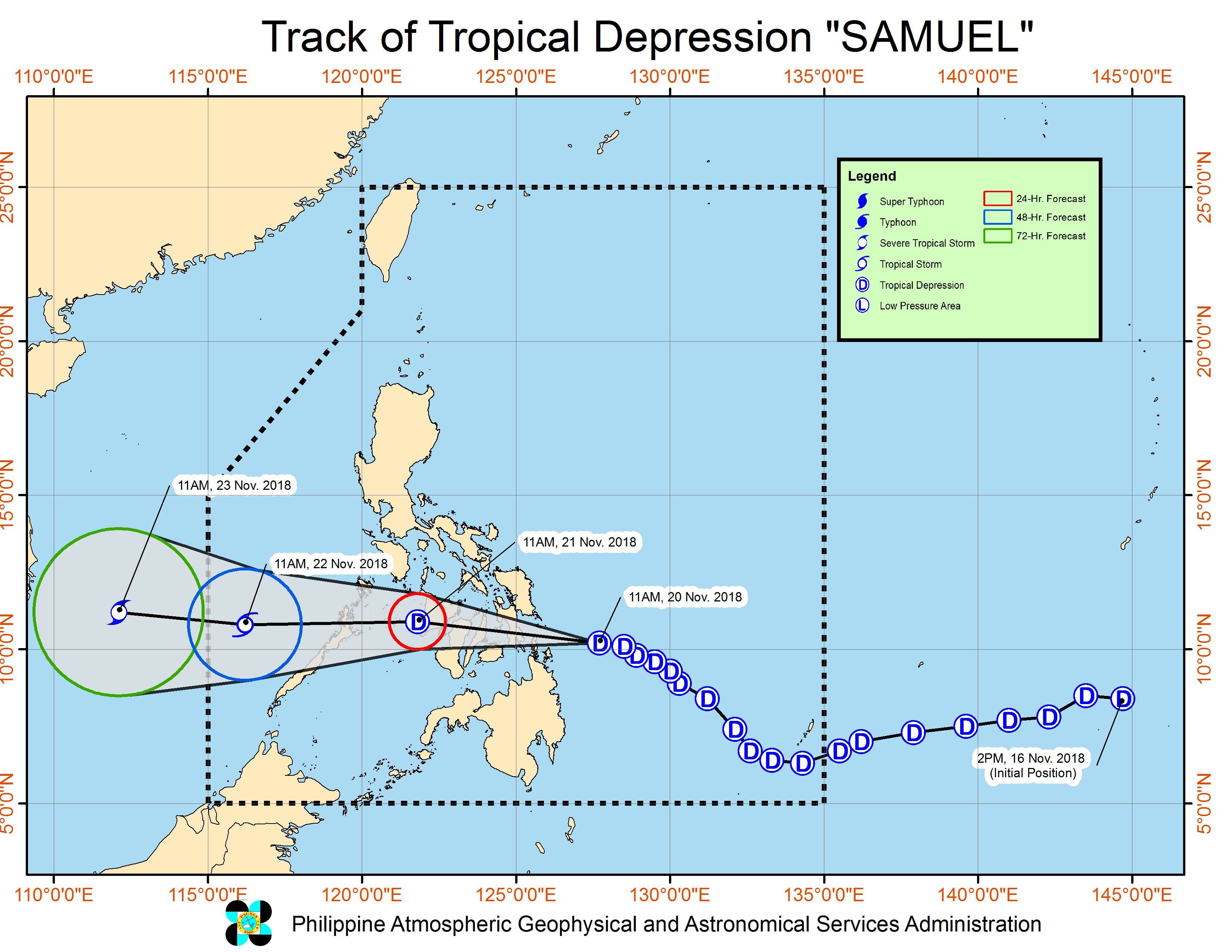
MANILA, Philippines – Tropical Depression Samuel is expected to make landfall in “the area between the southern portion of Eastern Samar and Dinagat Islands” on Tuesday evening, November 20.
In a bulletin issued 2 pm on Tuesday, the Philippine Atmospheric, Geophysical, and Astronomical Services Administration (PAGASA) said Samuel is already 260 kilometers east of Maasin City, Southern Leyte, or 185 kilometers east southeast of Guiuan, Eastern Samar.
It is still moving west northwest at 20 kilometers per hour (km/h).
The tropical depression also maintained its strength, with maximum winds of 55 km/h and gustiness of up to 65 km/h. But PAGASA reiterated that Samuel still poses a threat and should not be taken lightly.
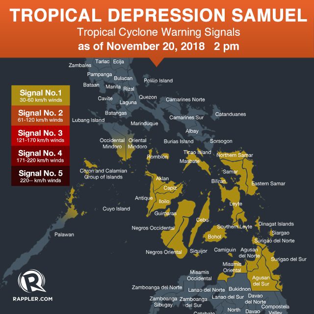
Signal No. 1 remains raised in:
- Masbate including Ticao Island
- Romblon
- southern part of Oriental Mindoro
- southern part of Occidental Mindoro
- northern part of Palawan including Cuyo Island and Calamian Group of Islands
- Northern Samar
- Eastern Samar
- Samar
- Biliran
- Leyte
- Southern Leyte
- Bohol
- Cebu
- Siquijor
- Negros Oriental
- Negros Occidental
- Guimaras
- Iloilo
- Capiz
- Aklan
- Antique
- Dinagat Islands
- Surigao del Norte
- Surigao del Sur
- Agusan del Norte
- Agusan del Sur
- Misamis Oriental
- Camiguin
PAGASA also warned that moderate to heavy rain may trigger flash floods and landslides in the Visayas, Dinagat Islands, Siargao Island, Sorsogon, Masbate, Albay, Camarines Sur, Catanduanes, Romblon, and Cuyo Island.
Residents of those areas should be on alert, especially if they live near rivers, in low-lying communities, or in mountainous regions. (READ: FAST FACTS: Tropical cyclones, rainfall advisories)
Classes have been suspended in parts of the Visayas and Mindanao for Tuesday. (READ: #WalangPasok: Class suspensions, Tuesday, November 20)
Fishermen and others with small sea vessels are also advised not to set sail in areas under Signal No. 1 and in the eastern seaboard of Southern Luzon.
A gale warning was issued at 5 am on Tuesday for Catanduanes, the eastern coast of Albay, and the eastern coast of Sorsogon.
Seas off those areas are rough to very rough, with wave heights reaching 2.6 meters to 4.5 meters.
If Samuel maintains its speed, it would exit the Philippine Area of Responsibility on Thursday evening, November 22.
Samuel is the Philippines’ 19th tropical cyclone for 2018. The country usually gets an average of 20 tropical cyclones per year. (READ: LIST: PAGASA’s names for tropical cyclones in 2018)
Meanwhile, the northeast monsoon or hanging amihan is still bringing isolated light rains to the Ilocos Region, Cordillera Administrative Region, Cagayan Valley, and Central Luzon on Tuesday. But PAGASA said there will be “no significant impact.”
Metro Manila and most of Calabarzon are only experiencing localized thunderstorms on Tuesday. But flash floods and landslides are possible if the thunderstorms become severe.
PAGASA declared the start of the rainy season last June 8. – Rappler.com
Add a comment
How does this make you feel?
There are no comments yet. Add your comment to start the conversation.