SUMMARY
This is AI generated summarization, which may have errors. For context, always refer to the full article.
What’s the weather like in your area? Tweet us at @rapplerdotcom.
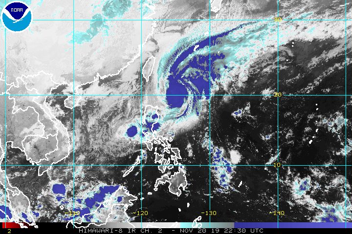
MANILA, Philippines – Sarah (Fung-wong) strengthened from a tropical storm into a severe tropical storm before dawn on Thursday, November 21, but fortunately, changed direction and appears less likely to make landfall.
In a briefing at 5 am on Thursday, the Philippine Atmospheric, Geophysical, and Astronomical Services Administration (PAGASA) said Sarah is already 425 kilometers east northeast of Aparri, Cagayan, or 340 kilometers east of Basco, Batanes.
The severe tropical storm is now moving north northwest, and not northwest, at a slower pace of 25 kilometers per hour (km/h) from the previous 35 km/h.
It now has maximum winds of 95 km/h from the previous 75 km/h and gustiness of up to 115 km/h from the previous 90 km/h.
“Owing to changes in the forecast track of Sarah, the tropical cyclone wind signal over mainland Cagayan is now lifted,” said PAGASA.
Only these areas remain under a tropical cyclone wind signal (TCWS):
Signal No. 1 (winds of 30 km/h to 60 km/h)
- Batanes
- Babuyan Group of Islands
“If these changes [in Sarah’s track] continue, there is a possibility that the TCWS over Batanes and Babuyan Islands will be lifted in the succeeding bulletins,” added PAGASA.
The state weather bureau also said, however, that gusty conditions could prevail in the northern and western parts of Northern Luzon due to the surge of the northeast monsoon or hanging amihan.
Meanwhile, the low pressure area (LPA) which used to be Ramon (Kalmaegi) is already 110 kilometers west of Subic, Zambales. Ramon had made landfall as a typhoon in Santa Ana, Cagayan, at 12:20 am on Wednesday, November 20, then gradually weakened.
PAGASA said that due to the LPA and Sarah’s trough or extension, there will be light to moderate rain with isolated heavy rainshowers on Thursday in the following areas:
- Isabela
- Cagayan (especially in the eastern section)
- Aurora
- northern part of Quezon
- Metro Manila
- most of Central Luzon
Residents of those areas are advised to monitor PAGASA advisories or warnings. (READ: FAST FACTS: Tropical cyclones, rainfall advisories)
Travel also remains risky, especially for small vessels, in the seaboards of areas under Signal No. 1, the seaboards of Northern Luzon and Central Luzon, and the western seaboard of Southern Luzon due to Sarah and the northeast monsoon.
According to PAGASA, Sarah may gradually weaken on Friday, November 22, or on Saturday, November 23.
It is expected to leave the Philippine Area of Responsibility on Saturday.
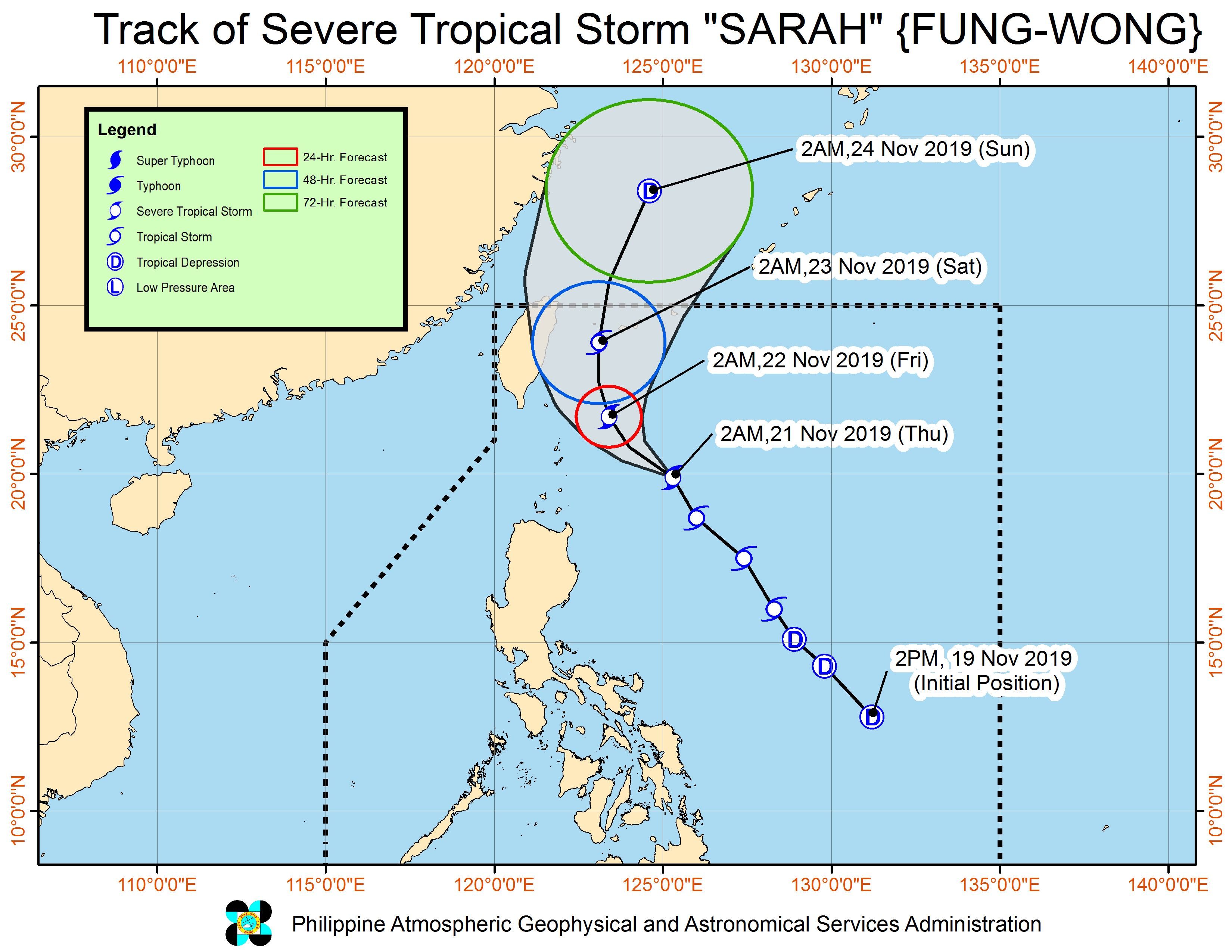
Sarah is the Philippines’ 19th tropical cyclone for 2019, and the 3rd for November. (READ: LIST: PAGASA’s names for tropical cyclones in 2019)
The country gets an average of 20 tropical cyclones annually, but since 2019 is an El Niño year, only 14 to 18 tropical cyclones had been projected.
With Sarah’s arrival, the estimate has been exceeded for the year and also for the month of November.
These had been the projections for the last two months of 2019:
- November – 1 or 2
- December – 0 or 1
PAGASA declared the start of the rainy season last June 14. – Rappler.com
Add a comment
How does this make you feel?
There are no comments yet. Add your comment to start the conversation.