SUMMARY
This is AI generated summarization, which may have errors. For context, always refer to the full article.
What’s the weather like in your area? Tweet us at @rapplerdotcom.
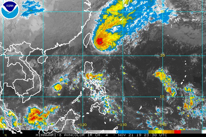
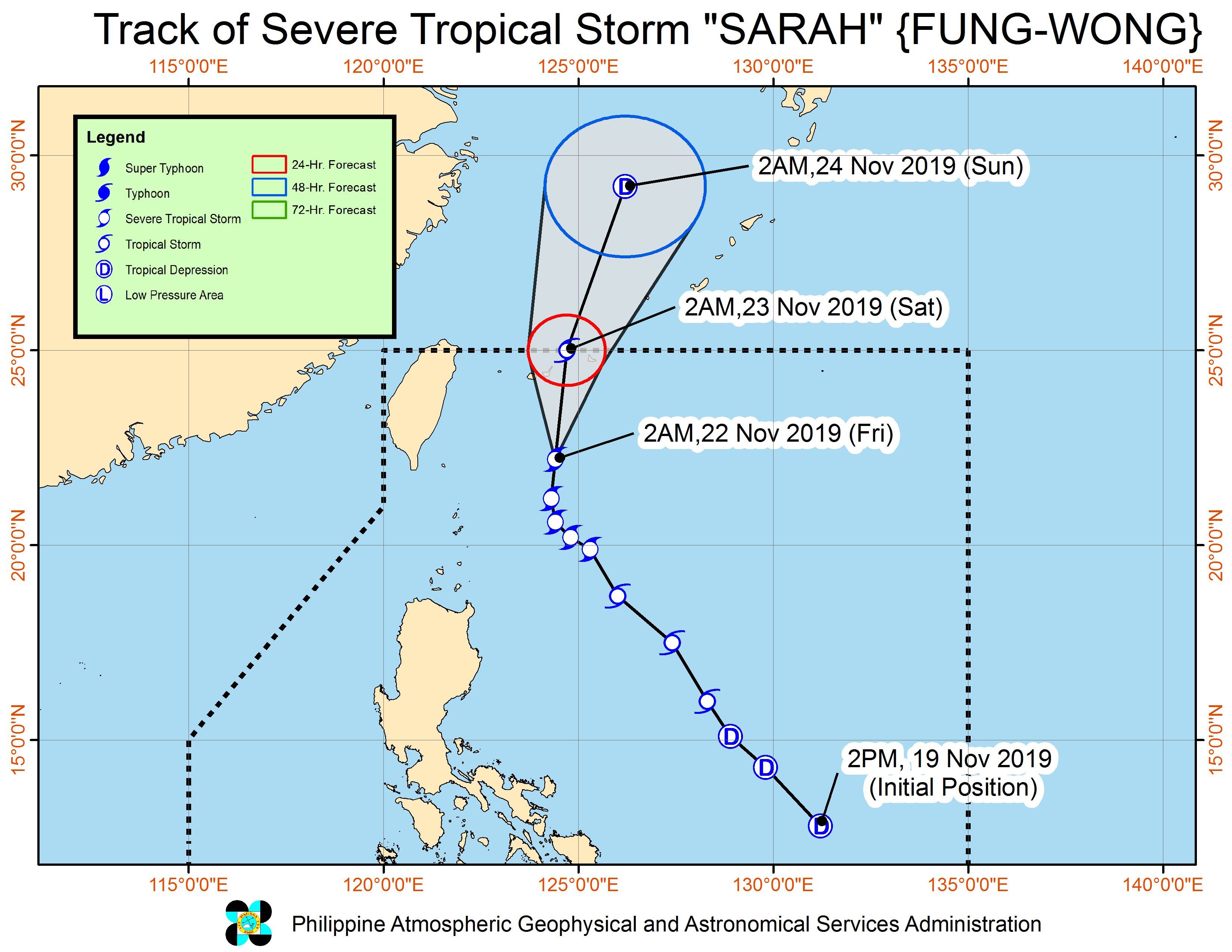
MANILA, Philippines – Severe Tropical Storm Sarah (Fung-wong) weakened as it began moving toward Japan’s Ryukyu Islands before dawn on Friday, November 22.
In a bulletin issued 5 am on Friday, the Philippine Atmospheric, Geophysical, and Astronomical Services Administration (PAGASA) said Sarah now has maximum winds of 95 kilometers per hour (km/h) from the previous 110 km/h and gustiness of up to 115 km/h from the previous 135 km/h.
The severe tropical storm is already 345 kilometers northeast of Basco, Batanes. It is moving north at a slightly faster pace of 20 km/h from the previous 10 km/h.
Since Sarah is moving away, the province of Batanes is no longer under Signal No. 1.
PAGASA noted, however, that gusts may still be experienced in Batanes and the Babuyan Group of Islands on Friday due to the surge of the northeast monsoon or hanging amihan. But this will “gradually weaken throughout the day,” added the state weather bureau.
Travel also remains risky, especially for small vessels, in the seaboards of Northern Luzon, particularly the areas below. This is due to the northeast monsoon.
- Batanes
- Cagayan, including Babuyan Group of Islands
- Ilocos Norte
- Ilocos Sur
- Isabela
Sarah did not make landfall in the Philippines, but its trough or extension earlier brought some rain to parts of Northern Luzon.
For Friday, PAGASA said Sarah “is no longer expected to bring significant rainfall activity over the country.” (READ: FAST FACTS: Tropical cyclones, rainfall advisories)
The severe tropical storm is expected to leave the Philippine Area of Responsibility (PAR) between Friday night and Saturday morning, November 23.
“It is forecast to gradually weaken as it moves towards the East China Sea in the next two days,” PAGASA added.
Sarah is the Philippines’ 19th tropical cyclone for 2019, and the 3rd for November. (READ: LIST: PAGASA’s names for tropical cyclones in 2019)
Meanwhile, the low pressure area which used to be Ramon (Kalmaegi) is already outside PAR, at 590 kilometers west of Coron, Palawan.
Ramon had made landfall as a typhoon in Santa Ana, Cagayan, at 12:20 am on Wednesday, November 20, then gradually weakened.
The country gets an average of 20 tropical cyclones annually, but since 2019 is an El Niño year, only 14 to 18 tropical cyclones had been projected.
With Sarah’s arrival, the estimate has been exceeded for the year and also for the month of November.
These had been the projections for the last two months of 2019:
- November – 1 or 2
- December – 0 or 1
PAGASA declared the start of the rainy season last June 14. – Rappler.com
Add a comment
How does this make you feel?
![[ANALYSIS] A new advocacy in race to financial literacy](https://www.rappler.com/tachyon/2024/04/advocacy-race-financial-literacy-April-19-2024.jpg?resize=257%2C257&crop_strategy=attention)


![[In This Economy] Can the PH become an upper-middle income country within this lifetime?](https://www.rappler.com/tachyon/2024/04/tl-ph-upper-income-country-04052024.jpg?resize=257%2C257&crop=295px%2C0px%2C720px%2C720px)
There are no comments yet. Add your comment to start the conversation.