SUMMARY
This is AI generated summarization, which may have errors. For context, always refer to the full article.
What’s the weather like in your area? Tweet us at @rapplerdotcom.
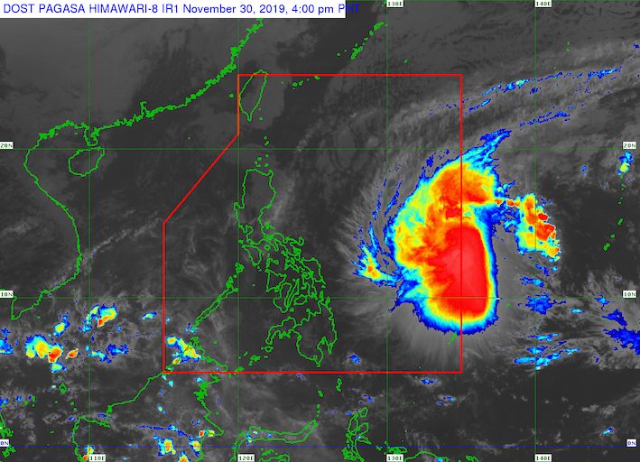
MANILA, Philippines (UPDATED) – The typhoon with the international name Kammuri entered the Philippine Area of Responsibility (PAR) at 4 pm on Saturday, November 30. It has been given the local name Tisoy.
In a briefing past 5 pm on Saturday, the Philippine Atmospheric, Geophysical, and Astronomical Services Administration (PAGASA) said Tisoy is already 1,165 kilometers east of Virac, Catanduanes.
It is still moving west southwest at 15 kilometers per hour (km/h).
Tisoy maintained its strength as it entered PAR, with maximum winds of 150 km/h and gustiness of up to 185 km/h.
The typhoon is expected to make landfall in Bicol between Monday afternoon, December 2, and early Tuesday morning, December 3.
Signal No. 1 is now raised in the following areas:
- Eastern Samar
- eastern part of Northern Samar (Laoang, Palapag, Mapanas, Gamay, Lapinig, Catubig, Las Navas)
This means winds of 30 km/h to 60 km/h may be experienced in those areas in 36 hours.
Even before Tisoy’s entry, PAGASA had warned that it would bring strong winds which may be destructive.
Aside from strong winds, the typhoon will also bring heavy rain beginning Monday. Below is PAGASA’s rainfall outlook:
Monday, December 2
- Occasional to frequent heavy rain
- Bicol
- Eastern Samar
- Northern Samar
- Samar
- Biliran
- Moderate to occasional heavy rain
- Romblon
- Marinduque
- Quezon
Tuesday, December 3
- Frequent to continuous heavy rain
- Metro Manila
- Bicol
- Calabarzon
- Occidental Mindoro
- Oriental Mindoro
- Marinduque
- Romblon
- Zambales
- Bataan
- Pampanga
- Bulacan
- Moderate to occasional heavy rain
- rest of Luzon
PAGASA warned that Tisoy may cause flash floods and landslides, especially near rivers, in low-lying communities, and in mountainous areas. Residents are advised to prepare and heed authorities’ warnings.
Some of the areas in the typhoon’s path are serving as venues for the 2019 Southeast Asian Games, which is formally opening with a ceremony at the Philippine Arena in Bulacan on Saturday and will be held until December 11.
PAGASA earlier said it is coordinating with the Philippine Southeast Asian Games Organizing Committee for weather updates specifically for the venues.
Travel is also risky, especially for small vessels, in the seaboards of areas under Signal No. 1, the northern and western seaboards of Northern Luzon, and the eastern seaboards of the Philippines.
Maritime trips are expected to be canceled due to the approaching typhoon. (READ: FAST FACTS: Tropical cyclones, rainfall advisories)
Based on its latest forecast track, Tisoy is expected to leave PAR on Thursday afternoon, December 5.
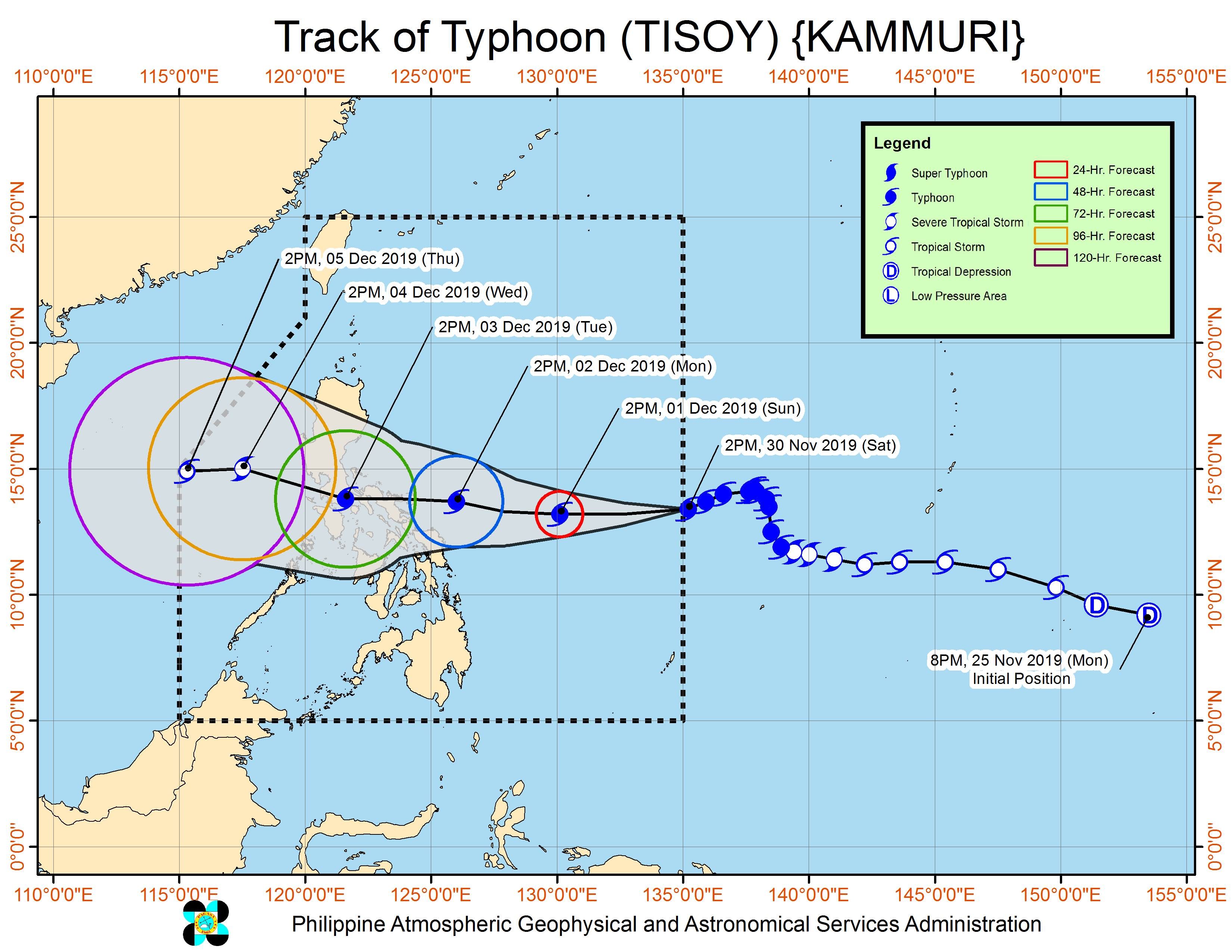
Tisoy is the Philippines’ 20th tropical cyclone for 2019, and the 4th for November. (READ: LIST: PAGASA’s names for tropical cyclones in 2019)
The country gets an average of 20 tropical cyclones annually. In the earlier part of the year, only 14 to 18 tropical cyclones had been projected since 2019 is an El Niño year.
For the month of December, PAGASA is expecting 0 to 1 tropical cyclone.
The state weather bureau said on Saturday morning that it spotted a new low pressure area (LPA) outside PAR, more than 3,000 kilometers east of Mindanao.
This LPA could intensify into a tropical depression and will be monitored.
PAGASA declared the start of the rainy season last June 14. – Rappler.com
Add a comment
How does this make you feel?
There are no comments yet. Add your comment to start the conversation.