SUMMARY
This is AI generated summarization, which may have errors. For context, always refer to the full article.
What’s the weather like in your area? Tweet us at @rapplerdotcom.
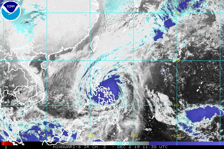
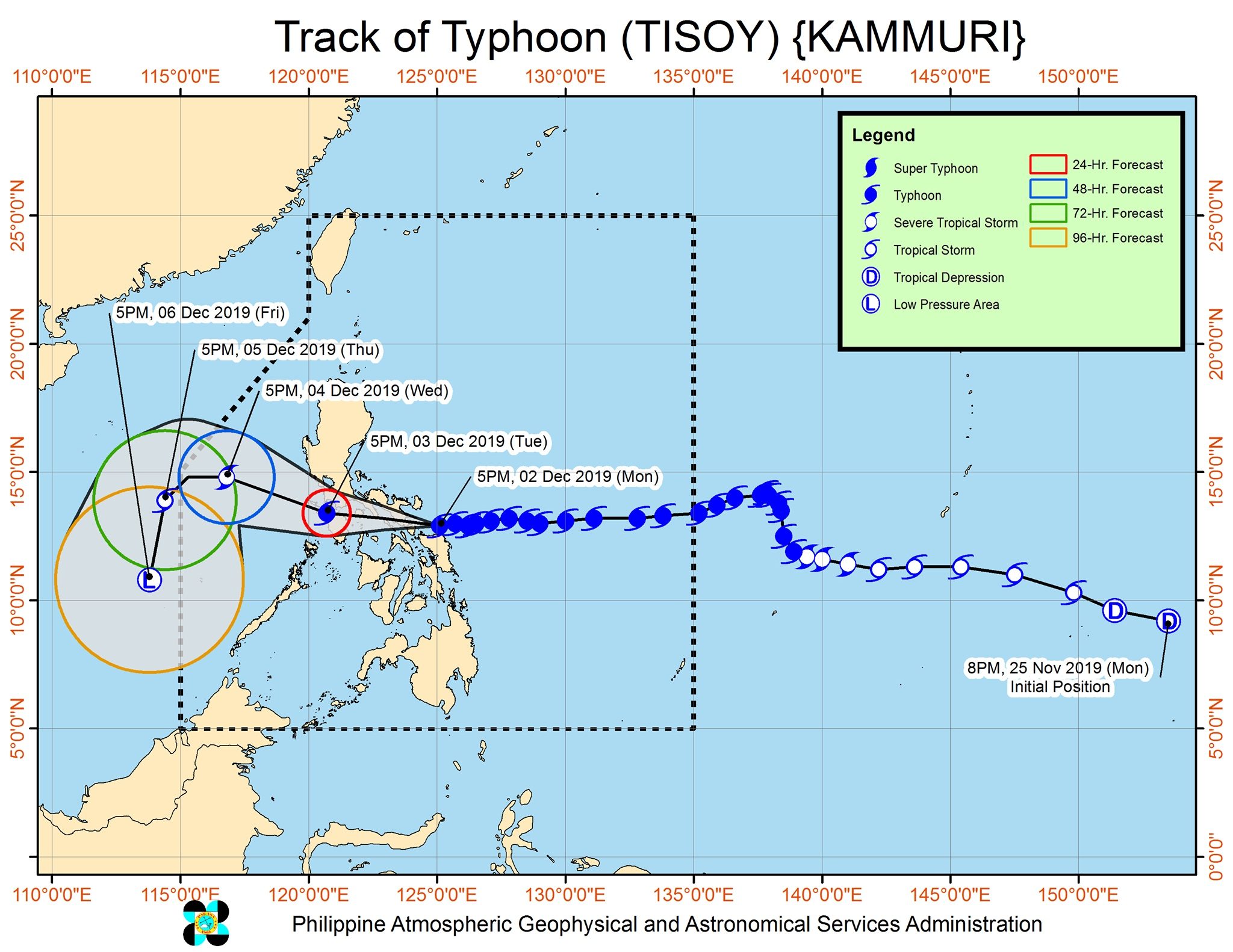
MANILA, Philippines – Typhoon Tisoy (Kammuri) gained even more strength early Monday evening, December 2, shortly before its expected landfall in the province of Sorsogon.
In a bulletin issued past 8 pm on Monday, the Philippine Atmospheric, Geophysical, and Astronomical Services Administration (PAGASA) said Tisoy is already 90 kilometers east of Juban, Sorsogon, with its landfall seen within the next 3 hours.
It slightly accelerated, moving west at 20 kilometers per hour (km/h) from the previous 15 km/h.
The typhoon now has maximum winds of 165 km/h from the previous 155 km/h and gustiness of up to 230 km/h from the previous 190 km/h. (READ: FAST FACTS: Tropical cyclones, rainfall advisories)
PAGASA said Tisoy’s eyewall is already bringing violent winds to Northern Samar, Catanduanes, Albay, Camarines Sur, and Sorsogon.
The World Meteorological Organization defines the eyewall as “an organized band or ring of cumulonimbus clouds that surround the eye, or light-wind center of a tropical cyclone.”
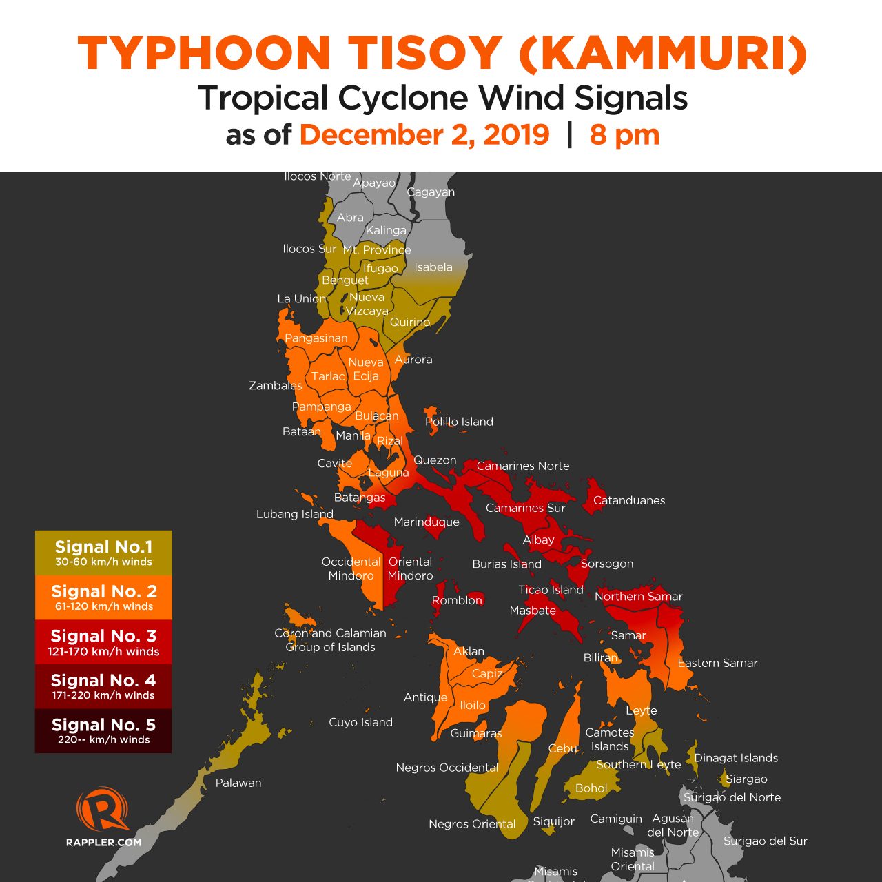
This is the newest list of areas under tropical cyclone wind signals:
Signal No. 3 (winds of 121 km/h to 170 km/h)
- Catanduanes
- Camarines Sur
- Albay
- Sorsogon
- Camarines Norte
- Masbate including Ticao Island and Burias Island
- Romblon
- southern part of Quezon (Perez, Alabat, Quezon, Mauban, Sampaloc, Lucban, Tayabas, Pagbilao, Lucena, Sariaya, Candelaria, Dolores, Tiaong, San Antonio, Atimonan, Padre Burgos, Agdangan, Plaridel, Unisan, Pitogo, Gumaca, Lopez, Macalelon, General Luna, Calauag, Guinayangan, Tagkawayan, Buenavista, Mulanay, San Narciso, San Francisco, San Andres)
- Marinduque
- Oriental Mindoro
- southern part of Batangas (San Juan, Padre Garcia, Ibaan, Batangas City, Rosario, Taysan, Lobo)
- Northern Samar
- northern part of Eastern Samar (Can-avid, Dolores, Maslog, Oras, Arteche, Jipapad, San Policarpio)
- northern part of Samar (Catbalogan, Jiabong, Motiong, Paranas, San Jose de Buan, San Jorge, Pagsanghan, Tarangnan, Sta Margarita, Gandara, Matuguinao, Calbayog, Tagapul-an, Almagro, Sto Niño)
Signal No. 2 (winds of 61 km/h to 120 km/h)
- Metro Manila
- Bulacan
- Bataan
- Tarlac
- Pampanga
- Nueva Ecija
- southern part of Aurora (Dipaculao, Maria Aurora, Baler, San Luis, Dingalan)
- Cavite
- rest of Batangas
- Laguna
- Rizal
- rest of Quezon including Polillo Island
- Occidental Mindoro
- Calamian Islands
- Zambales
- Cuyo Island
- Pangasinan
- rest of Eastern Samar
- rest of Samar
- Biliran
- Aklan
- Capiz
- Antique
- Iloilo
- northern part of Negros Occidental (Talisay, Calatrava, Silay, Enrique B Magalona, Victorias, Manapla, Cadiz, Sagay, Escalante, Toboso, Bacolod, Murcia, Salvador Benedicto, San Carlos, Bago, Pulupandan, Valladolid, La Carlota, San Enrique, Pontevedra, La Castellana, Moises Padilla)
- northern part of Cebu (Daanbantayan, Bantayan, Madridejos, Santa Fe, Medellin, Bogo City, San Remigio, Tabogon, Tabuelan, Tuburan, Carmen, Borbon, Sogod, Catmon, Asturias, Camotes Islands)
- northern part of Leyte (Baybay, Mahaplag, Abuyog, Javier, Macarthur, Mayorga, La Paz, Dulag, Albuera, Barauen, Julita, Tolosa, Tanauan, Tabontabon, Dagami, Pastrana, Palo, Sta Fe, Tacloban, Alangalang, Jaro, Babatngon, San Miguel, Barugo, Tunga, Carigara, Capoocan, Leyte, Calubian, San Isidro, Tabango, Villaba, Kananga, Matag-ob, Palompon, Isabel, Merida, Ormoc)
- Guimaras
Signal No. 1 (winds of 30 km/h to 60 km/h)
- southern part of Isabela (Palanan, Dinapigue, San Mariano, San Guillermo, Benito Soliven, Naguilian, Reina Mercedes, Luna, Aurora, Cabatuan, San Mateo, Cauayan City, Alicia, Angadanan, Ramon, San Isidro, Echague, Cordon, Santiago City, Jones, San Agustin)
- Mountain Province
- Ifugao
- Benguet
- Nueva Vizcaya
- Ilocos Sur
- La Union
- Quirino
- rest of Aurora
- northern part of Palawan (Taytay, Araceli, Dumaran, San Vicente, Roxas)
- rest of Negros Occidental
- Negros Oriental
- Bohol
- Siquijor
- rest of Cebu
- rest of Leyte
- Southern Leyte
- Dinagat Islands
- Siargao Island
PAGASA added that there may be gusty conditions in areas in Northern Luzon that are not under any tropical cyclone wind signal, due to the northeast monsoon or hanging amihan.
PAGASA maintained the following rainfall outlook for Tisoy:
Between Monday evening, December 2, and Tuesday morning, December 3
- Frequent to continuous heavy to intense rain
- Bicol
- Northern Samar
- southern part of Quezon
- Marinduque
- Romblon
- Frequent to continuous heavy rain
- Samar
- Eastern Samar
- Rizal
- rest of Quezon
- Laguna
- Oriental Mindoro
- Moderate rain to intermittent heavy rain
- Metro Manila
- Occidental Mindoro
- rest of Calabarzon
- Cagayan
- Isabela
- Aurora
- rest of Eastern Visayas
Between Tuesday morning and evening, December 3
- Frequent to continuous heavy to intense rain
- Calabarzon
- Central Luzon
- Metro Manila
- Occidental Mindoro
- Oriental Mindoro
- Marinduque
- Romblon
- Occasional to frequent heavy rain
- Cagayan Valley
- Cordillera Administrative Region
- Calamian Islands
- Intermittent heavy rain
- Aklan
- Capiz
- northern part of Antique
Residents must watch out for possible flash floods and landslides. (READ: Typhoon Kammuri track may be like Glenda in 2014, Reming in 2006)
Storm surges are also possible in certain coastal areas of these provinces:
More than 3 meters high
- Catanduanes
- Camarines Norte
- Camarines Sur
Up to 3 meters high
- Batangas
- Quezon
- Albay
- Marinduque
Travel is also risky, especially for small vessels, in the seaboards of areas under tropical cyclone wind signals, the seaboards of Northern Luzon, the western seaboard of Palawan, the central seaboards of the Visayas, and the northern and eastern seaboards of Mindanao.
Class suspensions were again being announced for Tuesday. (READ: #WalangPasok: Class suspensions, Tuesday, December 3, 2019)
The typhoon also prompted schedule adjustments to be made for some events of the 2019 Southeast Asian Games, which the Philippines is hosting until December 11. Some events were moved to an earlier time, while others were postponed.
Based on its latest forecast track, Tisoy is expected to leave the Philippine Area of Responsibility on Thursday, December 5.
Tisoy is the Philippines’ 20th tropical cyclone for 2019. (READ: LIST: PAGASA’s names for tropical cyclones in 2019)
The country gets an average of 20 tropical cyclones annually. In the earlier part of the year, only 14 to 18 tropical cyclones had been projected since 2019 is an El Niño year.
For the month of December, PAGASA had been expecting 0 to 1 tropical cyclone.
PAGASA declared the start of the rainy season last June 14. – Rappler.com
Add a comment
How does this make you feel?
There are no comments yet. Add your comment to start the conversation.