SUMMARY
This is AI generated summarization, which may have errors. For context, always refer to the full article.
What’s the weather like in your area? Tweet us at @rapplerdotcom.
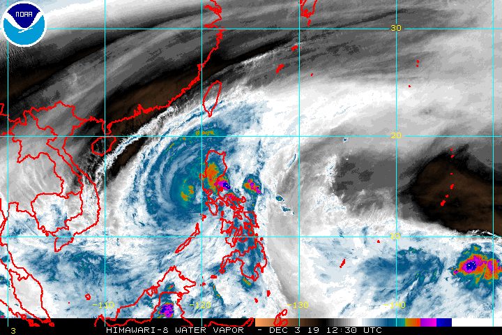
MANILA, Philippines – Typhoon Tisoy (Kammuri) maintained its strength as it moved over the Mindoro Strait early Tuesday evening, December 3.
In a bulletin issued 8 pm on Tuesday, the Philippine Atmospheric, Geophysical, and Astronomical Services Administration (PAGASA) said Tisoy is already 145 kilometers north of Coron, Palawan.
It is still moving west at a relatively fast 25 kilometers per hour (km/h).
Tisoy still has maximum winds of 130 km/h, while its gustiness is down to 160 km/h from the previous 200 km/h. (READ: FAST FACTS: Tropical cyclones, rainfall advisories)
Tisoy made landfall in the Philippines 4 times, bringing fierce winds and heavy rain.
- Gubat, Sorsogon – 11 pm on Monday, December 2
- San Pascual, Burias Island, Masbate – 4 am on Tuesday, December 3
- Torrijos, Marinduque – 8:30 am on Tuesday, December 3
- Naujan, Oriental Mindoro – 12:30 pm on Tuesday, December 3
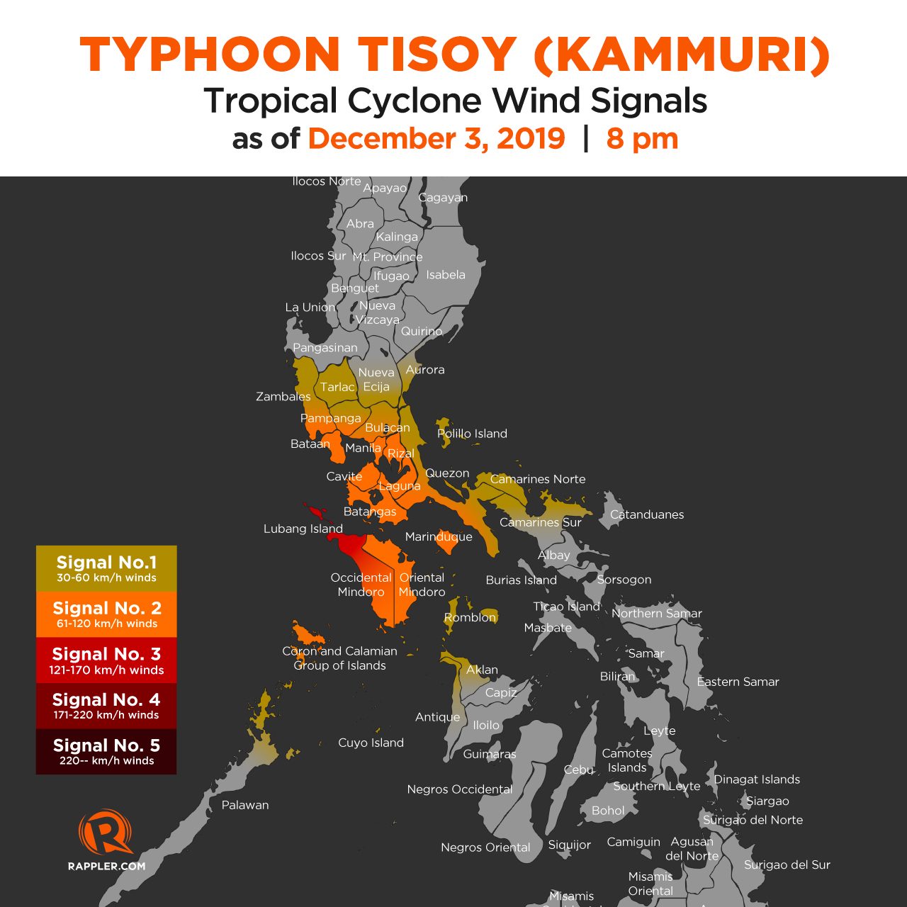
Here is the latest list of areas under tropical cyclone wind signals:
Signal No. 3 (winds of 121 km/h to 170 km/h)
- northern part of Occidental Mindoro (Abra de Ilog, Looc, Lubang, Mamburao, Paluan), including Lubang Island
Signal No. 2 (winds of 61 km/h to 120 km/h)
- Oriental Mindoro
- Batangas
- rest of Occidental Mindoro
- Marinduque
- Cavite
- Laguna
- Rizal
- Bataan
- Metro Manila
- southern part of Bulacan (Balagtas, Bocaue, Bulakan, Calumpit, Guiguinto, Hagonoy, Malolos City, Marilao, Meycauayan City, Obando, Paombong, Plaridel, Pulilan)
- southern part of Pampanga (Floridablanca, Lubao, Macabebe, Masantol, Sasmuan)
- southern part of Zambales (Castillejos, Olongapo City, San Antonio, San Felipe, San Marcelino, San Narciso, Subic)
- Calamian Islands (Coron, Busuanga, Culion, Linapacan)
- western part of Quezon (Dolores, Tiaong, Candelaria, Sariaya, San Antonio)
Signal No. 1 (winds of 30 km/h to 60 km/h)
- northern part of Camarines Sur (Cabugao, Libmanan, Pamplona, Pasacao, Sipocot, Lupi, Ragay, Del Gallego)
- southern part of Nueva Ecija (Cabanatuan City, Cabiao, Gabaldon, Gapan City, General Tinio, Jaen, Laur, Palayan City, Peñaranda, San Antonio, San Isidro, San Leonardo, Santa Rosa, Aliaga, Licab, Zaragoza)
- southern part of Aurora (Dipaculao, Maria Aurora, Baler, San Luis, Dingalan)
- northern part of Palawan (El Nido, Taytay, Araceli, Dumaran)
- Cuyo Islands (Cuyo, Magsaysay, Agutaya)
- Camarines Norte
- Tarlac
- rest of Quezon including Polillo Island
- Romblon
- rest of Zambales
- rest of Pampanga
- rest of Bulacan
- northern part of Aklan (Malay, Buruanga, Nabas, Ibajay)
- northern part of Antique (Caluya, Libertad, Pandan)
Gusty conditions may persist in parts of Northern Luzon, too, even if they are not under a tropical cyclone wind signal. This is due to the northeast monsoon or hanging amihan.
Rain will also continue in parts of Luzon. Below is PAGASA’s updated rainfall outlook.
Between Tuesday night, December 3, and Wednesday morning, December 4
- Frequent to continuous heavy rain, with isolated intense rain
- Quezon
- Rizal
- Occasional to frequent heavy rain
- Occidental Mindoro
- Oriental Mindoro
- rest of Calabarzon
- Marinduque
- Romblon
- Intermittent heavy rain
- Calamian Islands
- Metro Manila
- Central Luzon
- Cagayan Valley
- Cordillera Administrative Region
Flooding and extensive damage have been reported in Bicol. (IN PHOTOS: Typhoon Tisoy leaves trail of destruction across Bicol)
Travel also remains risky, especially for small vessels, in the seaboards of areas under tropical cyclone wind signals, the seaboards of Northern Luzon and the Visayas, the western seaboard of Palawan, and the northern and eastern seaboards of Mindanao.
The Philippine Coast Guard said there were at least 7,290 stranded passengers in Central Visayas, Southern Tagalog, Western Visayas, Bicol, Eastern Visayas, and Southern Visayas as of 12 pm on Tuesday.
Hundreds of domestic and international flights to and from the Philippines have also been canceled due to Tisoy. In Metro Manila, the Ninoy Aquino International Airport is closed for 12 hours on Tuesday.
Class suspensions are again being declared for Wednesday, December 4. (READ: #WalangPasok: Class suspensions, Wednesday, December 4, 2019)
Some events of the 2019 Southeast Asian (SEA) Games were either held earlier than scheduled or postponed to a later date. Organizers gave an assurance, however, that the SEA Games will not be extended.
Based on its latest forecast track, Tisoy is expected to leave the Philippine Area of Responsibility on Thursday morning, December 5.
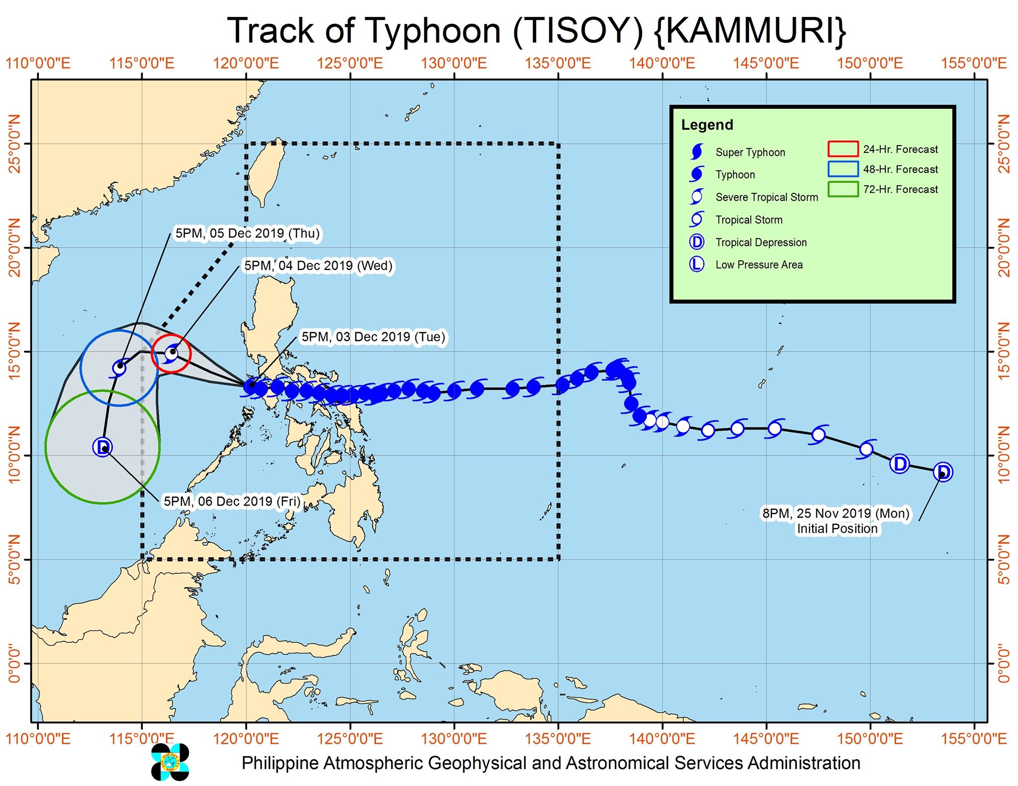
Tisoy is the Philippines’ 20th tropical cyclone for 2019. (READ: LIST: PAGASA’s names for tropical cyclones in 2019)
The country gets an average of 20 tropical cyclones annually. In the earlier part of the year, only 14 to 18 tropical cyclones had been projected since 2019 is an El Niño year.
For the month of December, PAGASA had been expecting 0 to 1 tropical cyclone.
PAGASA declared the start of the rainy season last June 14. – Rappler.com
Add a comment
How does this make you feel?


There are no comments yet. Add your comment to start the conversation.