SUMMARY
This is AI generated summarization, which may have errors. For context, always refer to the full article.

What’s the weather like in your area? Tweet us at @rapplerdotcom.
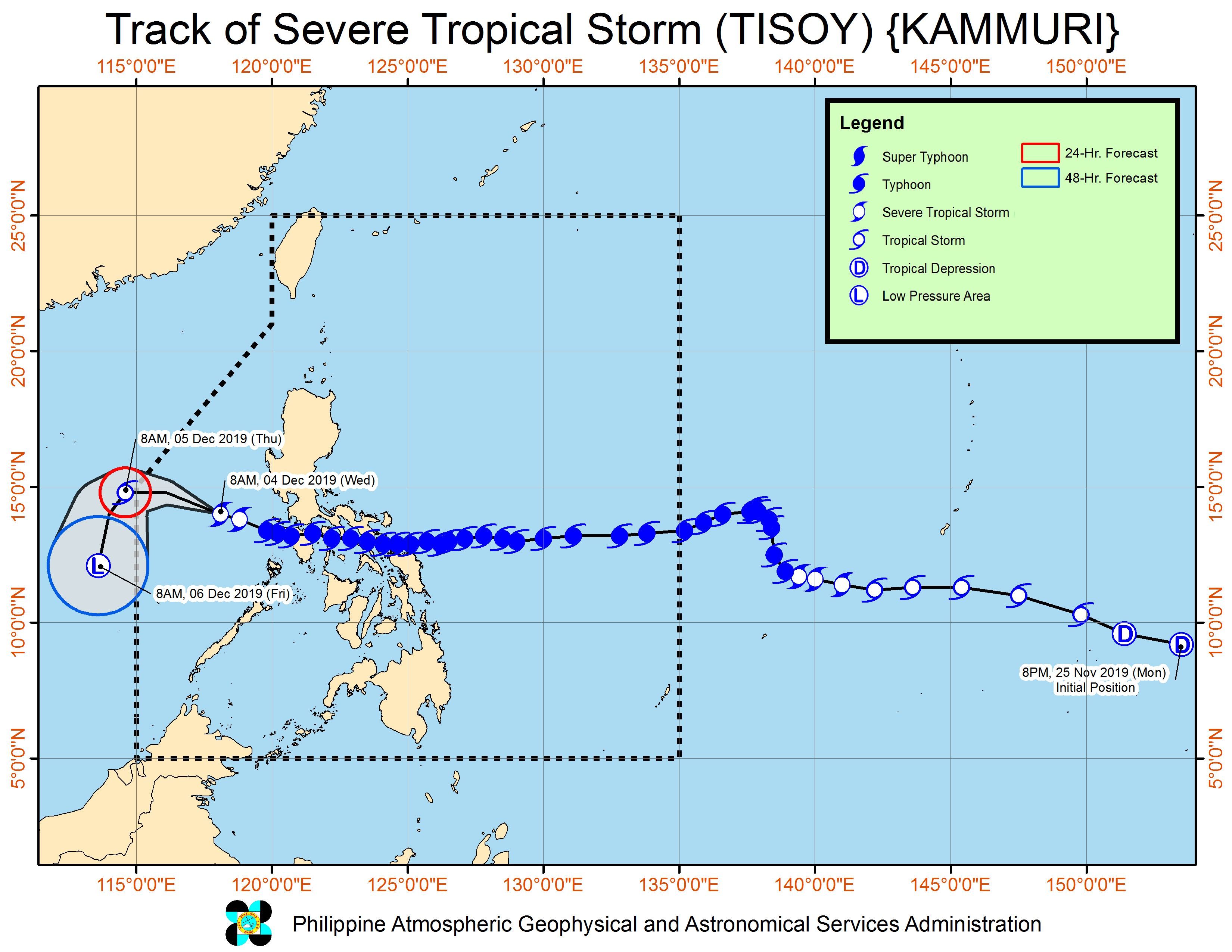
MANILA, Philippines – All tropical cyclone wind signals were lifted on Wednesday morning, December 4, as Severe Tropical Storm Tisoy (Kammuri), which used to be a typhoon, was making its way out of the Philippine Area of Responsibility (PAR).
In a briefing past 11 am on Wednesday, the Philippine Atmospheric, Geophysical, and Astronomical Services Administration (PAGASA) said Tisoy is already 290 kilometers west southwest of Subic, Zambales.
It slowed down a bit and is now moving west northwest at 15 kilometers per hour (km/h) from the previous 20 km/h.
As expected, Tisoy is gradually weakening due to the northeast monsoon or hanging amihan, which is cold air. Warm air fuels tropical cyclones. (READ: FAST FACTS: Tropical cyclones, rainfall advisories)
Tisoy now has maximum winds of 95 km/h from the previous 100 km/h and gustiness of up to 115 km/h from the previous 125 km/h.
At the time of its first landfall as a typhoon, Tisoy had maximum winds of 175 km/h and gustiness of up to 240 km/h.
In total, it made landfall 4 times:
- Gubat, Sorsogon – 11 pm on Monday, December 2
- San Pascual, Burias Island, Masbate – 4 am on Tuesday, December 3
- Torrijos, Marinduque – 8:30 am on Tuesday, December 3
- Naujan, Oriental Mindoro – 12:30 pm on Tuesday, December 3
The region of Bicol was hard hit. In Albay, hundreds of families were left homeless, while the Legazpi City Domestic Airport sustained heavy damage.
Flooding and damage were also reported in Samar Island. (READ: #ReliefPH: Help victims of Typhoon Tisoy)
During the typhoon’s onslaught, as high as Signal No. 3 had been raised. (READ: Why is it now called tropical cyclone ‘wind’ – and not ‘warning’ – signals?)
While Tisoy will soon leave PAR, however, the northeast monsoon is still affecting parts of Luzon.
There may still be moderate to occasional heavy rain in the following areas, which could cause flash floods and landslides:
- Ilocos Region
- Cagayan Valley
- Cordillera Administrative Region
- Aurora
Gusty conditions may also be experienced in other areas of:
- Northern Luzon
- Central Luzon
- Calabarzon
- Mimaropa
Travel also remains risky in the seaboards of Northern Luzon, the eastern seaboard of Central Luzon, and the eastern and western seaboards of Southern Luzon.
The Philippine Coast Guard earlier said more than 7,000 passengers were stranded at the height of Tisoy’s onslaught.
Hundreds of domestic and international flights to and from the Philippines were also canceled. In Metro Manila, the Ninoy Aquino International Airport was closed for 7 hours on Tuesday, December 3, then reopened earlier than scheduled for recovery flights.
Classes remain suspended in various areas on Wednesday. (READ: #WalangPasok: Class suspensions, Wednesday, December 4, 2019)
Tisoy also disrupted some events of the 2019 Southeast Asian Games, which were either held earlier or postponed. But organizers said the regional meet will wrap up as scheduled next Wednesday, December 11.
Tisoy is expected to leave PAR between Wednesday evening and Thursday morning, December 5.
Tisoy is the Philippines’ 20th tropical cyclone for 2019. (READ: LIST: PAGASA’s names for tropical cyclones in 2019)
The country gets an average of 20 tropical cyclones annually. In the earlier part of the year, only 14 to 18 tropical cyclones had been projected since 2019 is an El Niño year.
For the month of December, PAGASA had been expecting 0 to 1 tropical cyclone.
PAGASA declared the start of the rainy season last June 14. – Rappler.com
Add a comment
How does this make you feel?
There are no comments yet. Add your comment to start the conversation.