SUMMARY
This is AI generated summarization, which may have errors. For context, always refer to the full article.
What’s the weather like in your area? Tweet us at @rapplerdotcom.
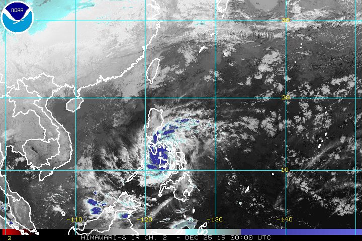
MANILA, Philippines – Typhoon Ursula (Phanfone) maintained its strength but slightly slowed down early Wednesday morning, December 25, Christmas Day, with stormy weather to persist in Western Visayas, Central Visayas, and Mimaropa.
In a bulletin issued 8 am on Wednesday, the Philippine Atmospheric, Geophysical, and Astronomical Services Administration (PAGASA) said Ursula is already 30 kilometers northwest of Roxas City, Capiz, or 95 kilometers south southeast of Romblon town, Romblon.
The typhoon is now moving west at a slower 20 kilometers per hour (km/h) from the previous 25 km/h.
It continues to have maximum winds of 140 km/h and gustiness of up to 195 km/h.
So far, Ursula has made landfall 4 times:
- Salcedo, Eastern Samar – 4:45 pm, Tuesday, December 24
- Tacloban City, Leyte – 7:30 pm, Tuesday, December 24
- Cabucgayan, Biliran – 9:15 pm, Tuesday, December 24
- Gigantes Islands, Carles, Iloilo – 2:30 am, Wednesday, December 25
PAGASA warned that Ursula’s eyewall is now bringing very destructive winds and intense rainfall to the southwestern part of Masbate, Aklan, Capiz, the northern part of Antique, the northeastern part of Iloilo, and Romblon.
The World Meteorological Organization defines the eyewall as “an organized band or ring of cumulonimbus clouds that surround the eye, or light-wind center of a tropical cyclone.”
“In case of the passage of the eye in some of the aforementioned areas, calm conditions will be experienced. However, as soon as the eye moves out of the area, violent conditions associated with the eyewall will resume,” PAGASA said.
Below is the latest list of areas under tropical cyclone wind signals. (READ: Why is it now called tropical cyclone ‘wind’ – and not ‘warning’ – signals?)
Signal No. 3 (winds of 121 km/h to 170 km/h)
- western part of Masbate (Milagros, Aroroy, Mandaon, Balud)
- Romblon
- southern part of Oriental Mindoro (Roxas, Mansalay, Bulalacao, Bongabong, Bansud)
- southern part of Occidental Mindoro (Calintaan, Rizal, San Jose, Magsaysay, southern part of Sablayan)
- Calamian Islands (Busuanga, Coron, Culion)
- Capiz
- Aklan
- northern part of Antique (Libertad, Pandan, Sebaste, Culasi, Tibiao, Barbaza, Laua-an)
- northern part of Iloilo (Calinog, Bingawan, Passi City, San Enrique, San Rafael, Barotac Viejo, Ajuy, Lemery, Sara, Concepcion, San Dionisio, Batad, Estancia, Balasan, Carles)
Signal No. 2 (winds of 61 km/h to 120 km/h)
- southern part of Quezon (Macalelon, General Luna, Catanauan, Mulanay, San Narciso, San Andres, San Francisco)
- Marinduque
- rest of Oriental Mindoro
- rest of Occidental Mindoro including Lubang Island
- Albay
- Sorsogon
- rest of Masbate including Ticao and Burias Islands
- Cuyo Islands
- extreme northern part of mainland Palawan (Linapacan, El Nido, Taytay, Araceli)
- extreme northern part of Cebu including Bantayan Islands (Daanbantayan, Medellin, Bantayan, Sta Fe, Madridejos, Bogo City, San Remigio, Tabogon, Tabuelan)
- rest of Iloilo
- rest of Antique
- Guimaras
- northern part of Negros Occidental (Valladolid, Pulupandan, Bago City, Murcia, San Carlos City, Salvador Benedicto, Bacolod City, Talisay, Silay City, Enrique B Magalona, Victorias City, Manapla, Cadiz City, Sagay City, Escalante City, Toboso, Calatrava)
Signal No. 1 (winds of 30 km/h to 60 km/h)
- Bataan
- Metro Manila
- Rizal
- Cavite
- rest of Quezon
- Laguna
- Batangas
- Camarines Sur
- Camarines Norte
- Catanduanes
- rest of northern part of mainland Palawan (Dumaran, San Vicente, Roxas)
- Cagayancillo Islands
- Northern Samar
- Samar
- Eastern Samar
- Biliran
- Leyte
- Bohol
- rest of Cebu
- rest of Negros Occidental
- Negros Oriental
PAGASA also updated additional information on tropical cyclone winds:
Wednesday morning, December 25
- destructive typhoon-force winds in Occidental Mindoro and Oriental Mindoro
- damaging gale- to storm-force winds in Calamian Islands and Cuyo Islands
- moderate to strong winds in the northern part of Palawan and most of Calabarzon
Wednesday afternoon, December 25
- destructive typhoon-force winds in Calamian Islands
- moderate to strong winds in Metro Manila and Bataan
In terms of rainfall, below is the latest on what to expect for Christmas Day. Note that Metro Manila has been added to the areas experiencing light to moderate rain with isolated heavy rainshowers.
Until Wednesday evening, December 25
- Occasional to frequent heavy rain with intermittent intense rain
- Masbate
- northern part of Negros Occidental
- northern part of Negros Oriental
- Aklan
- Antique
- Capiz
- Iloilo
- Guimaras
- Romblon
- Calamian Islands
- Cuyo Islands
- Occidental Mindoro
- Oriental Mindoro
- Light to moderate rain with isolated heavy rainshowers
- Bicol
- rest of Visayas
- Calabarzon
- Metro Manila
- Marinduque
- Aurora
- northern part of mainland Palawan
There could be flash floods and landslides in areas affected by Ursula. (READ: FAST FACTS: Tropical cyclones, rainfall advisories)
There may also be storm surges 1 to 2 meters high within the next 24 hours in these provinces:
- southern part of Masbate
- Aklan
- Capiz
- northern part of Antique
- northeastern part of Iloilo
- Romblon
- Marinduque
- Occidental Mindoro
- Oriental Mindoro
- Calamian Islands
- Cuyo Islands
Travel remains risky in the seaboards of areas under tropical cyclone wind signals, the seaboards of Aurora, and the northern and eastern seaboards of Mindanao due to rough waters.
The Philippine Coast Guard said there have been at least 23,789 stranded passengers in Bicol, Central Visayas, Eastern Visayas, Southern Tagalog, Northern Mindanao, Western Visayas, and Southern Visayas.
There are canceled domestic flights as well.
Based on its latest forecast track, Ursula is expected to leave the Philippine Area of Responsibility late Friday, December 27, or early Saturday, December 28.
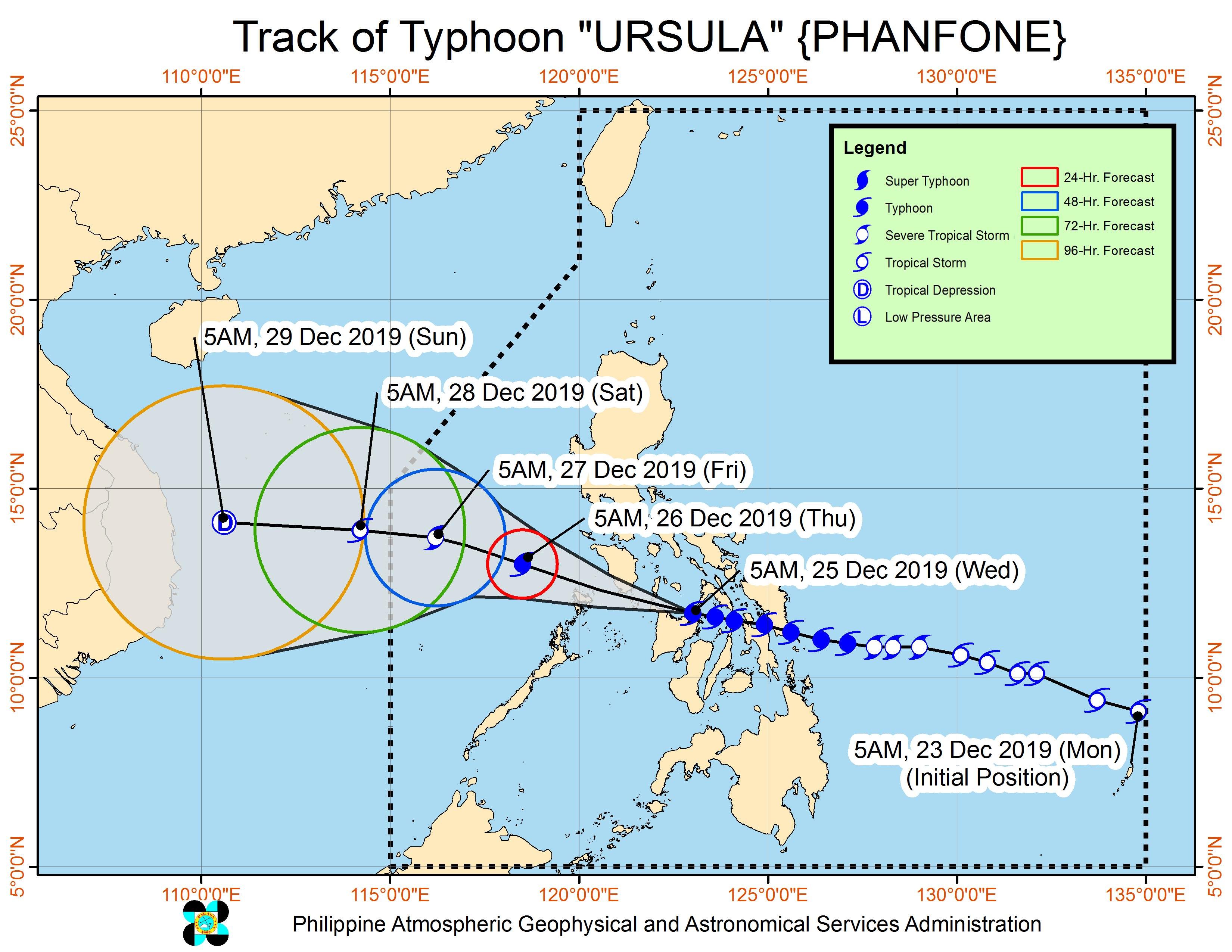
Ursula is the Philippines’ 21st tropical cyclone for 2019, exceeding the yearly average of 20. (READ: LIST: PAGASA’s names for tropical cyclones in 2019)
Ursula is also the second tropical cyclone for December, after Typhoon Tisoy (Kammuri). PAGASA earlier said it was expecting one or two tropical cyclones during the month.
In December 2018, the Philippines had a deadly tropical cyclone during Christmas – Tropical Depression Usman. It left 156 people dead and 105 others injured in Eastern Visayas, Bicol, and Mimaropa, according to the National Disaster Risk Reduction and Management Council.
PAGASA declared the start of the rainy season last June 14. – Rappler.com
Add a comment
How does this make you feel?
There are no comments yet. Add your comment to start the conversation.