SUMMARY
This is AI generated summarization, which may have errors. For context, always refer to the full article.
What’s the weather like in your area? Tweet us at @rapplerdotcom.
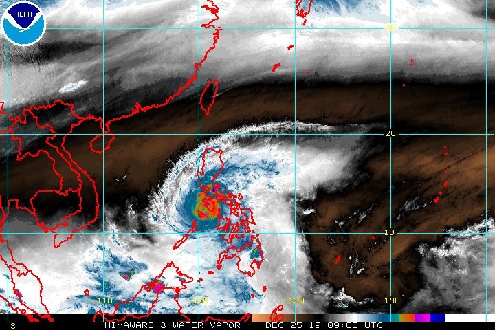
MANILA, Philippines – Typhoon Ursula (Phanfone) made its 7th landfall in Oriental Mindoro on Wednesday afternoon, December 25, leaving a trail of destruction in areas in its path right during Christmas.
In a briefing past 5 pm on Wednesday, the Philippine Atmospheric, Geophysical, and Astronomical Services Administration (PAGASA) said Ursula is already off the coast of Magsaysay, Occidental Mindoro, or 15 kilometers south southwest of San Jose, Occidental Mindoro.
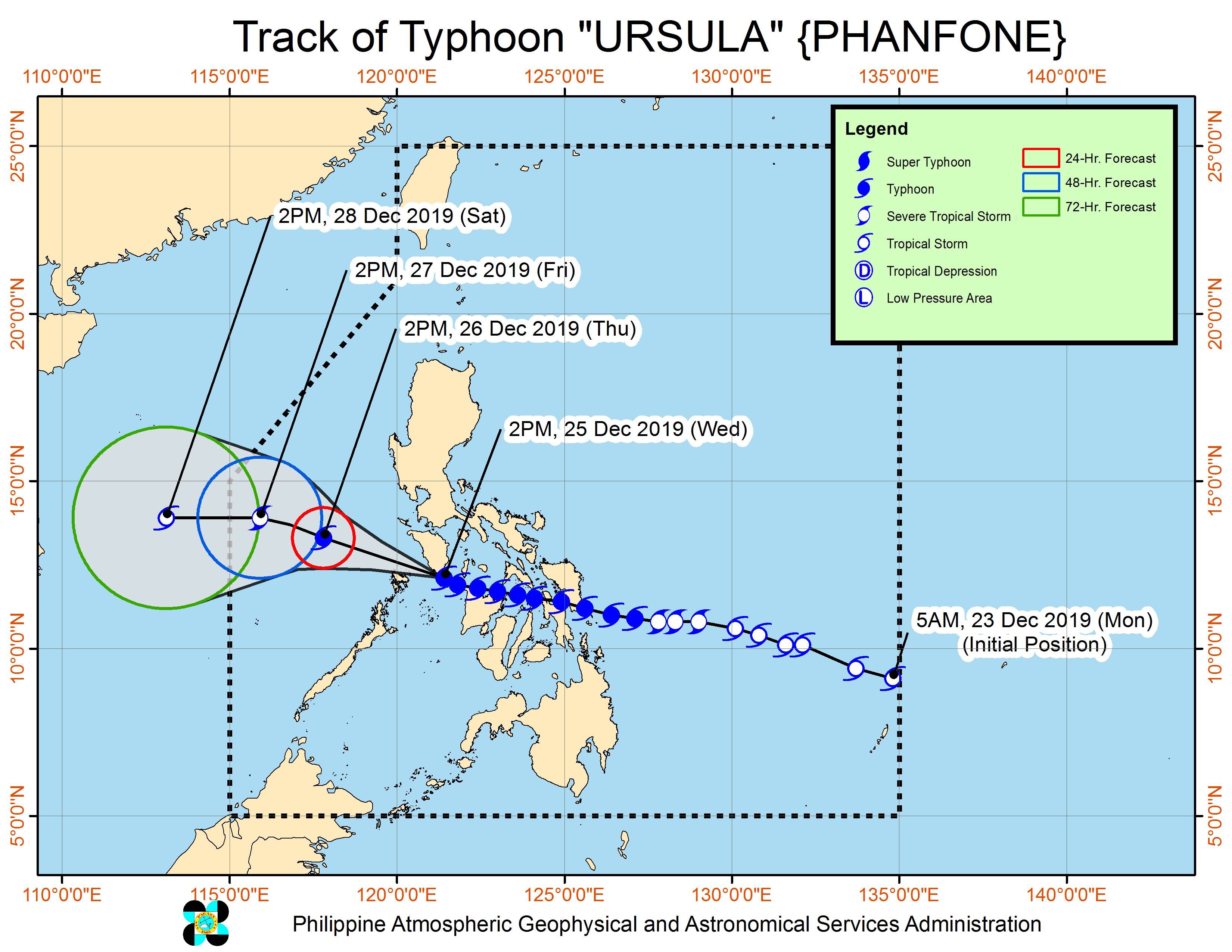
The typhoon is moving west northwest at the same pace of 20 kilometers per hour (km/h). It also maintained its strength, with maximum winds of 140 km/h and gustiness of up to 195 km/h.
Ursula’s first 3 landfalls were in Eastern Visayas on Christmas Eve, next 3 landfalls in Western Visayas on Christmas Day, and then the 7th landfall in Oriental Mindoro, also on Christmas Day.
Tuesday, December 24
- Salcedo, Eastern Samar – 4:45 pm
- Tacloban City, Leyte – 7:30 pm
- Cabucgayan, Biliran – 9:15 pm
Wednesday, December 25
- Gigantes Islands, Carles, Iloilo – 2:30 am
- Ibajay, Aklan – 8:40 am
- Semirara Island, Caluya, Antique – 1 pm
- Bulalacao, Oriental Mindoro – 3 pm
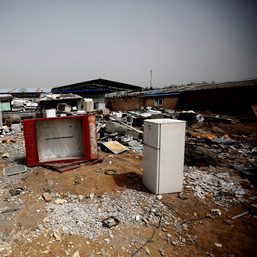
Ursula’s onslaught triggered heavy flooding and caused serious damage.
The typhoon’s eyewall continues to trigger very destructive winds and intense rainfall in the southern parts of Occidental Mindoro and Oriental Mindoro.
The Calamian Islands will also be affected by the eyewall in the coming hours, warned PAGASA. Destructive typhoon-force winds are expected there on Wednesday evening.
The World Meteorological Organization defines the eyewall as “an organized band or ring of cumulonimbus clouds that surround the eye, or light-wind center of a tropical cyclone.”
“In case of the passage of the eye…calm conditions will be experienced. However, as soon as the eye moves out of the area, violent conditions associated with the eyewall will resume,” PAGASA said.
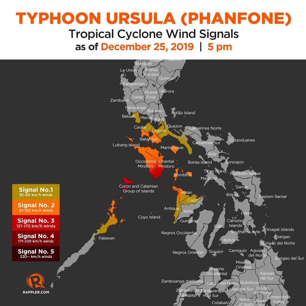
There are no more tropical cyclone wind signals for Metro Manila, Rizal, Camarines Norte, Camarines Sur, Albay, Masbate including Ticao and Burias Islands, Cagayancillo Island, the northern part of Negros Occidental, Iloilo, and Guimaras.
But Signal Nos. 1, 2, and 3 are still in effect for several areas. (READ: Why is it now called tropical cyclone ‘wind’ – and not ‘warning’ – signals?)
Signal No. 3 (winds of 121 km/h to 170 km/h)
- southern part of Oriental Mindoro (Roxas, Mansalay, Bulalacao, Bongabong, Bansud, Pola, Socorro, Pinamalayan, Gloria)
- southern part of Occidental Mindoro (Calintaan, Rizal, San Jose, Magsaysay, southern part of Sablayan)
- Calamian Islands (Busuanga, Coron, Culion)
Signal No. 2 (winds of 61 km/h to 120 km/h)
- Romblon
- Batangas
- Marinduque
- rest of Oriental Mindoro
- rest of Occidental Mindoro including Lubang Island
- Cuyo Islands
- extreme northern part of mainland Palawan (Linapacan, El Nido, Taytay, Araceli)
- northern part of Antique (Libertad, Pandan, Sebaste, Culasi)
- northwestern part of Aklan (Malay, Nabas, Buruanga, Ibajay, Tangalan, Makato, Numancia, Lazo, Kalibo, Banga, Malinao, Madalag)
Signal No. 1 (winds of 30 km/h to 60 km/h)
- Bataan
- Cavite
- Laguna
- rest of the northern part of mainland Palawan (Dumaran, San Vicente, Roxas)
- southern part of Quezon (Mauban, Sampaloc, Lucban, Tayabas, Lucena, Dolores, Candelaria, Sariaya, Tiaong, San Antonio, Pagbilao, Atimonan, Padre Burgos, Plaridel, Agdangan, Unisan, Gumaca, Pitogo, Macalelon, General Luna, Catanauan, Mulanay, San Francisco, San Andres, San Narciso, Buenavista, Lopez, Guinayangan, Calauag, Alabat, Perez, Quezon)
- Capiz
- rest of Antique
- rest of Aklan
Rain from Ursula will also persist on Wednesday evening, particularly for the areas still listed below. (READ: FAST FACTS: Tropical cyclones, rainfall advisories)
Occasional to frequent heavy rain with intermittent intense rain
- Calamian Islands
- Cuyo Islands
- Occidental Mindoro
- Oriental Mindoro
Light to moderate rain with intermittent heavy rain
- Romblon
- Aklan
- Capiz
- Calabarzon
- Marinduque
- Aurora
- northern part of mainland Palawan
There may also be storm surges 1 to 2 meters high in these areas:
- Negros Occidental
- Calamian Islands
Travel remains risky in the seaboards of areas under tropical cyclone wind signals.
The Philippine Coast Guard said there were at least 23,789 stranded passengers in Bicol, Central Visayas, Eastern Visayas, Southern Tagalog, Northern Mindanao, Western Visayas, and Southern Visayas. Some sea trips have since resumed with the lifting of tropical cyclone wind signals for certain areas.
Dozens of domestic flights were canceled on Christmas Eve and Christmas Day as well.
Based on its latest forecast track, Ursula is expected to leave the Philippine Area of Responsibility on Friday, December 27.
Ursula is the Philippines’ 21st tropical cyclone for 2019, exceeding the yearly average of 20. (READ: LIST: PAGASA’s names for tropical cyclones in 2019)
Ursula is also the second tropical cyclone for December, after Typhoon Tisoy (Kammuri). PAGASA earlier said it was expecting one or two tropical cyclones during the month.
In December 2018, the Philippines had a deadly tropical cyclone during Christmas – Tropical Depression Usman. It left 156 people dead and 105 others injured in Eastern Visayas, Bicol, and Mimaropa, according to the National Disaster Risk Reduction and Management Council.
PAGASA declared the start of the rainy season last June 14. – Rappler.com
Add a comment
How does this make you feel?
![[OPINION] Fossil fuel debts are illegitimate and must be canceled](https://www.rappler.com/tachyon/2024/04/IMHO-fossil-fuel-debt-cancelled-April-16-2024.jpg?resize=257%2C257&crop_strategy=attention)
![[WATCH] John Kerry: You can’t solve climate crisis without addressing ocean’s challenges](https://www.rappler.com/tachyon/2023/12/cop28-united-states-john-kerry-december-2-2023-reuters-001.jpg?resize=257%2C257&crop_strategy=attention)


There are no comments yet. Add your comment to start the conversation.