SUMMARY
This is AI generated summarization, which may have errors. For context, always refer to the full article.
What’s the weather like in your area? Tweet us at @rapplerdotcom.
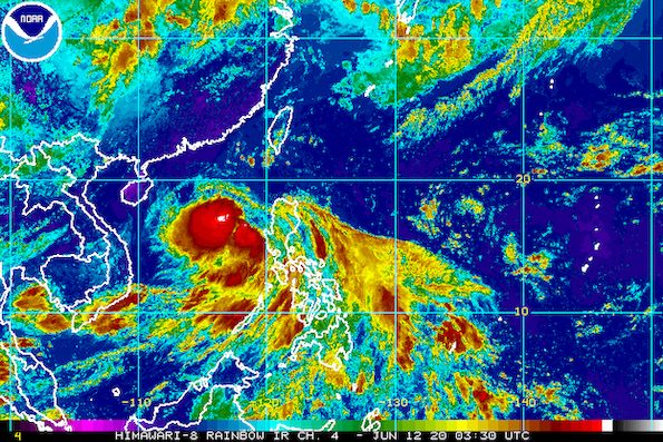
MANILA, Philippines – Tropical Depression Butchoy is making its way out of the Philippine Area of Responsibility (PAR), but the southwest monsoon or hanging habagat will trigger more rain on Friday, June 12.
In an online briefing past 11 am on Friday, the Philippine Atmospheric, Geophysical, and Astronomical Services Administration (PAGASA) said Butchoy is already 140 kilometers west northwest of Iba, Zambales, or 165 kilometers west of Dagupan City, Pangasinan.
It is still moving west northwest, but at a faster 25 kilometers per hour (km/h) from the previous 15 km/h.
If it maintains its pace, Butchoy may leave PAR either Friday night or Saturday morning, June 13, and then head for the southern part of China.
The tropical depression had made landfall twice in Quezon province on Thursday, June 11 – Polillo at 5:30 pm and Infanta at 6 pm – before swiftly crossing Central Luzon late Thursday and early Friday.
Butchoy also slightly intensified late Friday morning. Its maximum winds increased from 45 km/h to 55 km/h, while its gustiness remains at 70 km/h.
PAGASA said Butchoy is likely to strengthen into a tropical storm within 24 hours, while still inside PAR. (READ: FAST FACTS: Tropical cyclones, rainfall advisories)
As of 11 am on Friday, there are no more areas under Signal No. 1. (READ: Why is it now called tropical cyclone ‘wind’ – and not ‘warning’ – signals?)
But PAGASA said occasional gusts due to the southwest monsoon may still be experienced over most of Northern Luzon and Central Luzon as well as the western parts of Southern Luzon and the Visayas.
The state weather bureau also gave the following rainfall outlook for the rest of Friday:
Moderate to heavy rain
- Zambales
- Bataan
- Pangasinan
- northern part of Palawan including Calamian and Cuyo Islands
- Occidental Mindoro
Light to moderate – with at times heavy – monsoon rain
- rest of Luzon
- Western Visayas
Butchoy and the southwest monsoon will cause moderate to very rough seas with waves 1.5 to 4.5 meters high in the seaboards of Northern Luzon and Central Luzon, especially in the Ilocos Region, Zambales, and Bataan. PAGASA warned that travel is risky, especially for small vessels.

Also on Friday, PAGASA declared the start of the rainy season in the country.
Butchoy is the Philippines’ second tropical cyclone for 2020. The first was Typhoon Ambo (Vongfong) last May.
The country gets an average of 20 tropical cyclones per year. (READ: LIST: PAGASA’s names for tropical cyclones in 2020)
In PAGASA’s climate outlook, it gave the following estimates for the number of tropical cyclones in the next 6 months:
- June – 1 or 2
- July – 2 to 4
- August – 2 or 3
- September – 2 or 3
- October – 2 or 3
- November – 1 or 2
– Rappler.com
Add a comment
How does this make you feel?
There are no comments yet. Add your comment to start the conversation.