SUMMARY
This is AI generated summarization, which may have errors. For context, always refer to the full article.
What’s the weather like in your area? Tweet us the situation: Use #weatheralert and tag @rapplerdotcom.
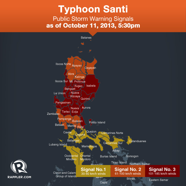
MANILA, Philippines (2nd UPDATE) – The state weather bureau on Friday afternoon, October 11, placed 14 areas under Storm Warning Signal No. 3 as it expects typhoon Santi to make landfall in less than 9 hours.
It raised storm warning signals over 21 other areas, including Metro Manila, which is under Signal No. 2.
In its 5 pm update, the Philippine Atmospheric, Geophysical, and Astronomical Services Administration (PAGASA) placed the following areas under Signal No. 3:
-
Aurora
-
Isabela
-
Quirino
-
Nueva Vizcaya
-
Ifugao
-
Benguet
-
La Union
-
Ilocos Sur
-
Pangasinan
-
Mt Province
-
Tarlac
-
Nueva Ecija
-
Northern Quezon including Polilio Island
-
Northern Zambales
PAGASA placed the following areas under Signal No. 2:
-
Metro Manila
-
Ilocos Norte
-
Cagayan
-
Apayao
-
Kalinga
-
Abra
-
Rest of Zambales
-
Pampanga
-
Bataan
-
Bulacan
-
Rizal
It placed the following under Signal No. 1:
-
Calayan and Babuyan Group of Islands
-
Cavite
-
Batangas
-
Laguna
-
Northern Mindoro
-
Lubang Islands
-
Rest of Quezon
-
Marinduque
-
Camarines Provinces
-
Catanduanes
Santi packs maximum winds of 150 km/h and gustiness of up to 185 km/h. It moves in a westward direction at 15 km/h.
The typhoon will make landfall over the Aurora-Isabela area any time from 12 mn to 2 am on Saturday, October 12, PAGASA said.
It is expected to leave the Philippine area of responsibility on Sunday, October 13. Once Santi leaves, storm Tino is seen entering the country. – Rappler.com
Add a comment
How does this make you feel?
There are no comments yet. Add your comment to start the conversation.