SUMMARY
This is AI generated summarization, which may have errors. For context, always refer to the full article.
What’s the weather like in your area? Tweet us: Use #weatheralert and tag @rapplerdotcom.
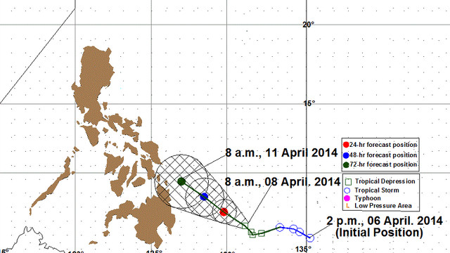
MANILA, Philippines – Tropical Depression Domeng has changed course and is now moving slowly northwest instead of its earlier direction of west northwest.
At 10 am, state weather bureau PAGASA spotted Domeng 550 kilometers east of Davao City. It is moving at 5 kilometers per hour with maximum sustained winds at 55 kph.
It is expected to be 360 kilometers east of Hinatuan, Surigao del Sur on Wednesday, April 9. On Thursday, it will be 230 km east of Hinatuan, Surigao del Sur. On Friday, it will be north northeast of Hinatuan, Surigao del Sur.
According to PAGASA forecaster Jory Loiz, Domeng is not due to make landfall in the next 3 days.
Localities within Domeng’s 400 kilometer diameter can expect moderate to heavy rainfall or 5 to 15 millimeters of rain per hour.
The tropical depression can still get stronger, said Loiz. But as of their latest update, no locality will be affected by the weather system in the next 36 hours.
According to Weather Philippines, an independent weather group, Domeng may make landfall over the border between Surigao del Norte and Surigao del Sur on Thursday afternoon, April 10.
Residents along Mindanao and the Visayas are advised to monitor weather conditions and alerts in the area.
(Data from Weather Philippines is not official data. Official weather information is issued by state weather bureau PAGASA.)
Domeng may cause storm surges a little less than 1 meter (3.3 feet) in provinces in the Visayas and Mindanao, according to data from Project NOAH (INFOGRAPHIC: Storm surge 101: Are you at risk? Are you prepared for it?) – Rappler.com
Add a comment
How does this make you feel?
There are no comments yet. Add your comment to start the conversation.