SUMMARY
This is AI generated summarization, which may have errors. For context, always refer to the full article.
What’s the weather like in your area? Tweet us the situation: Use #weatheralert and tag @rapplerdotcom.
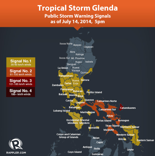
MANILA, Philippines – Tropical Storm Glenda (international codename Rammasun) has strengthened as it continued to move westward threatening the Bicol region on Monday afternoon, July 14, prompting state weather bureau PAGASA to declare Public Storm Warning Signal No 3 over Catanduanes.
In its July 14, 5 pm update, PAGASA said Glenda clocked in maximum sustained winds of 110 kilometers per hour (kph) with gustiness of up to 140 kph.
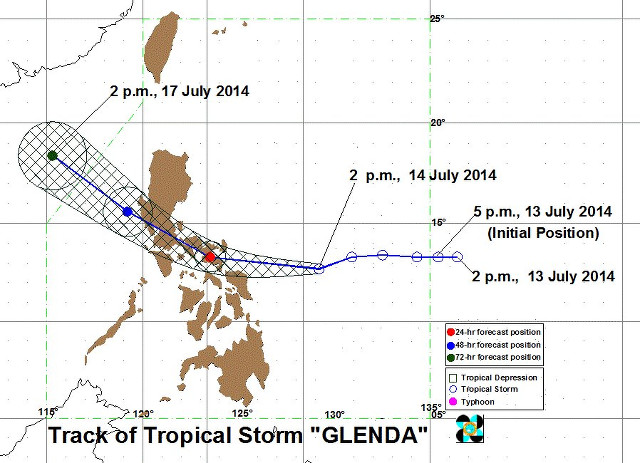
As of 4 pm, it was spotted 470 km east southeast of Virac, Catanduanes. It is expected to continue moving westward at 30 kph.
The only province under Signal No 3 so far, Catanduanes can expect winds of 101 to 185 kph within at least 18 hours.
Storm Signal No 2 (winds of 61-100 kph) has been declared over the following areas:
- Camarines Norte
- Camarines Sur
- Masbate (including Burias and Ticao Islands)
- Sorsogon
- Albay
- Marinduque
- Southern Quezon
- Northern Samar
Meanwhile, these areas are currently under Signal Number 1 (winds of 30-60 kph):
- Romblon
- Occidental Mindoro
- Oriental Mindoro
- Lubang Island
- Batangas
- Cavite
- Laguna
- Rizal
- Bulacan
- Pampanga
- Bataan
- Zambales
- Tarlac
- Nueva Ecija
- Pangasinan
- Southern Aurora
- Northern Quezon (including Polillo Islands)
- Metro Manila
- Eastern Samar
- Samar
- Biliran
The storm is expected to make landfall over Albay on Tuesday, July 15, the bureau said.
The storm may be out of the Philippine Area of Responsibility on Thursday. It will traverse the southern Luzon, and its center will pass near Metro Manila. It will likely exit near the Bataan-Zambales area towards the West Philippine Sea, the bureau added.
Precautions
Authorities said they were taking every precaution to avoid fatalities, after Super Typhoon Haiyan left about 7,300 people dead or missing when it tore across the central Philippines in November last year.
“We are already warning the public to be on alert for possible effects of the weather disturbance: landslides, flash floods, strong rains and winds,” said Alexander Pama, head of the National Disaster Risk Reduction and Management Council (NDRRMC).
The disaster management council said it had already alerted over 1,300 villages susceptible to floods or landslides they were in Glenda’s direct path and residents should be prepared to shelter in evacuation centers.
The second level of a 3-step storm alert has been raised over the Bicol region southeast of Manila, where the storm is expected to first hit. Classes on all levels have already been suspended.
Heavy rain is also expected to fall over the central islands that bore the brunt of Haiyan and where thousands of people are still living in tents or other makeshift evacuation centers.
Storm alerts have also been hoisted for the more than 12 million people in Manila, with some classes having already been suspended.
NDRRMC spokeswoman Mina Marasigan warned that the storm could become even more powerful as it moves across the sea.
She said there were concerns it might bring rainfall comparable to Typhoon Milenyo (Xangsane) in 2006, which killed more than 200 people and displaced nearly two million due largely to widespread and heavy flooding. – With reports from Agence France-Presse/Rappler.com
Learn how to prepare for the coming storm on Rappler’s Project Agos microsite.
Add a comment
How does this make you feel?
There are no comments yet. Add your comment to start the conversation.