SUMMARY
This is AI generated summarization, which may have errors. For context, always refer to the full article.

What’s the weather like in your area? Tweet us the situation: Use #weatheralert and tag @rapplerdotcom.
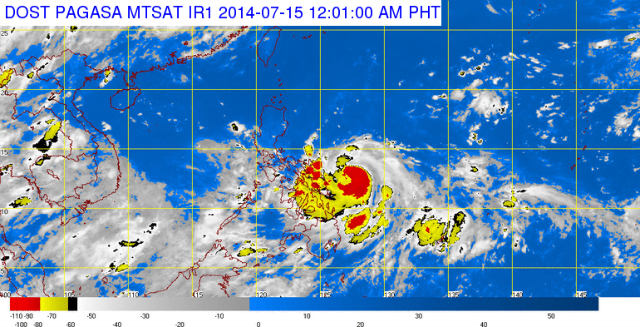
MANILA, Philippines – Now a typhoon, Glenda (Rammasun) slowed down on Monday evening, July 14, as it moved toward the Bicol region, the state weather bureau said.
The Philippine Atmospheric, Geophysical, and Astronomical Services Administration (PAGASA), in its 11 pm update, then raised storm warning signals over 30 areas mostly in Luzon. (READ: #GlendaPH: Latest info and critical alerts)
The affected areas include the National Capital Region, which is under Storm Warning Signal No. 1.
PAGASA warned the following areas to prepare for Glenda, as the state weather bureau placed these under storm warning signals:
Signal No. 3:
(With winds of 101-185 km/h expected in at least 18 hours)
-
Catanduanes
-
Albay
-
Sorsogon
-
Northern Samar
Signal No. 2:
(With winds of 61-100 km/h expected in at least 24 hours)
-
Camarines Norte
-
Camarines Sur
-
Masbate, including Burias and Ticao Islands
-
Marinduque
-
Southern part of Quezon
-
Northern part of Samar
-
Northern part of Eastern Samar
Signal No. 1:
(With winds of 30-60 km/h expected in at least 36 hours)
-
Romblon
-
Oriental and Occidental Mindoro
-
Lubang Island
-
Batangas
-
Cavite
-
Laguna
-
Rizal
-
Bulacan
-
Pampanga
-
Bataan
-
Zambales
-
Tarlac
-
Nueva Ecija
-
Pangasinan
-
Southern Aurora
-
Rest of Quezon including Polillo Islands
-
Metro Manila
-
Rest of Eastern Samar and of Samar
-
Northern Leyte including Biliran Island
In its 11 pm update Monday, PAGASA said it expects Glenda to make landfall over the Albay-Sorsogon area by Tuesday evening, July 15.
Then Glenda is expected to cross Albay toward Southern Luzon, PAGASA said.
It is likely to be within the vicinity of the National Capital Region by Wednesday morning, July 16. It is seen to exit the landmass through the Zambales area by Wednesday afternoon.
PAGASA said Glenda will likely be outside the Philippine area of responsibility, 550 kilometers west of Laoag City, by Thursday evening, July 17.
Glenda packs maximum sustained winds of 120 km/h near the center and gustiness of up to 150 km/h. It is forecast to move west at 20 km/h. – Rappler.com
Stay alert and ready with the latest weather and disaster information through Project Agos.
Add a comment
How does this make you feel?
There are no comments yet. Add your comment to start the conversation.