SUMMARY
This is AI generated summarization, which may have errors. For context, always refer to the full article.
What’s the weather like in your area? Tweet us the situation: Use #weatheralert and tag @rapplerdotcom
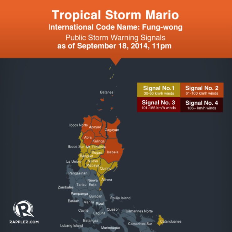
- Cagayan, including Calayan and Babuyan Group of Islands
- Isabela
- Kalinga
- Apayao
- Abra
- Ilocos Norte
These areas will experience stormy weather with rough to very rough seas.
Meanwhile, public storm warning signal number 1 is raised over:
- Catanduanes
- Aurora
- Quirino
- Nueva Vizcaya
- Ifugao
- Benguet
- Mountain Province
- Ilocos Sur
- La Union
- Batanes Group of Islands
These areas will have rains with gusty winds, and moderate to rough seas.
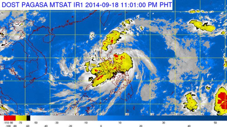
The combined effect of Mario and the Southwest Monsoon will bring moderate to heavy rains and thunderstorms in the regions of Bicol, Eastern Visayas, and Central Visayas which may trigger flashfloods and landslides.
Mario is expected to be in the vicinity of Aparri, Cagayan, by Friday evening, September 19; at 90 km northwest of the Calayan Group of Islands by Saturday night, September 20; and, at 493 km north northeast of Basco, Batanes by Sunday evening, September 21.
The next bulletin for Mario will be issued at 5 am Friday.
Meanwhile, in its 5 pm weather bulletin on Thursday, PAGASA said the rest of Luzon and of Visayas, Zamboanga Peninsula, Northern Mindanao and Caraga will have cloudy skies with light to moderate rains and thunderstorms.
The rest of Mindanao will be partly cloudy to cloudy with isolated rainshowers or thunderstorms.
Coastal seas will be moderate to rough as moderate to strong winds blow from the northwest to southwest over Southern Luzon, Visayas, and Mindanao, and from the northeast to northwest over the rest of Luzon.
| City | Forecast | Temperature Range |
|
| Metro Manila |  |
Cloudy skies with rainshowers and/or thunderstorms |
23°C-30°C |
| Tuguegarao |  |
Stormy | 20°C-28°C |
| Laoag |  |
Rains with gusty winds | 22°C-29°C |
| Baguio | |
Rains with gusty winds | 15°C-21°C |
| Subic/Olongapo; Clark/Angeles | |
Cloudy skies with rainshowers and/or thunderstorms |
23°C-30°C |
| Tagaytay | |
Cloudy skies with rainshowers and/or thunderstorms |
20°C-28°C |
| Lipa | |
Cloudy skies with rainshowers and/or thunderstorms |
21°C-30°C |
| Legazpi | |
Cloudy skies with rainshowers and/or thunderstorms |
23°C-28°C |
| Puerto Princesa | |
Cloudy skies with rainshowers and/or thunderstorms |
23°C-29°C |
| Iloilo/Bacolod | |
Cloudy skies with rainshowers and/or thunderstorms |
23°C-31°C |
| Metro Cebu | |
Cloudy skies with rainshowers and/or thunderstorms |
23°C-28°C |
| Tacloban | |
Cloudy skies with rainshowers and/or thunderstorms |
23°C-29°C |
| Cagayan de Oro | |
Cloudy skies with rainshowers and/or thunderstorms |
20°C-31°C |
| Metro Davao |  |
Partly cloudy to cloudy skies with isolated rainshowers or thunderstorms |
23°C-33°C |
| Zamboanga | |
Cloudy skies with rainshowers and/or thunderstorms |
23°C-31°C |
– Rappler.com
Add a comment
How does this make you feel?
There are no comments yet. Add your comment to start the conversation.