SUMMARY
This is AI generated summarization, which may have errors. For context, always refer to the full article.

What’s the weather like in your area? Tweet us the situation: Use #weatheralert and tag @rapplerdotcom
MANILA, Philippines (2nd UPDATE) – Typhoon Ruby (Hagupit) has a big chance of hitting land in Eastern Samar this Saturday, December 6, state weather bureau PAGASA said Thursday, December 4.
Ruby, last located 860 km east of Surigao City, further strengthened Thursday morning, the bureau said, with winds of up to 195 km/h near the center and gusts of up to 230 km/h as of 10 am.
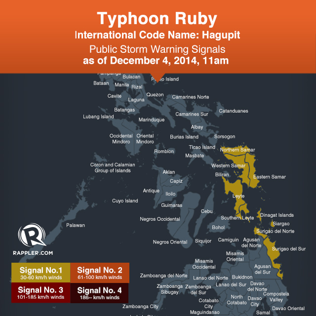
The typhoon is still too far to affect any part of the country as of this moment, the bureau said, but it has raised public storm warning signal number 1 over the following areas:
- Samar
- Eastern Samar
- Northern Samar
- Leyte
- Southern Leyte
- Surigao del Norte, including Siargao Island
- Surigao del Sur
- Biliran
- Dinagat Islands
It is carrying heavy to intense rainfall (7.5-20 mm/h), the bureau said. The storm is a big one, with a 700-kilometer diameter.
Current PAGASA forecast models show that the typhoon is expected to hit land in Eastern Samar by Saturday morning, but there is still a possibility for the typhoon to move away from the area and curve northeast.
“By Saturday morning, it is expected to be at 30 km northeast of Borongan, Eastern Samar and will make landfall over the Samar area before noon. By Sunday morning [December 7], it is expected to be at 20 km south southwest of Romblon,” the bureau said in its 11 am bulletin.
PAGASA has compared Ruby’s winds to 2012’s Typhoon Pablo (Bopha) which had wind strengths of 185 to 220 km/h.
Aside from the areas under storm signals, Central and Southern Luzon, Western Visayas, Bicol, and Northeast Mindanao may be affected by the typhoon.
Storm surges of 3.5 to 4 meters are expected in parts of Eastern Visayas. Project NOAH Executive Director said the highest of these surges are likely in Catarman, Borongan and Guiuan in Samar and the Tacloban Straight in Leyte.
While PAGASA still refers to Ruby as a typhoon, other weather services have referred to it as a super typhoon already.
The US Navy’s Joint Typhoon Warning Center (JTWC) last reported Ruby as having winds of up to 287 km/h near the center, and gusts of up to 350 km/h.
The Japan Meteorological Agency (JMA) said the typhoon is a “violent” weather system.
“Other weather services are calling it a ‘super typhoon’ but we will only adopt this term next year,” PAGASA Administrator Vicente Malano said.
This is because PAGASA still has to conduct a nationwide Information and Education Campaign to raise awareness on the use of the term. They define a super typhoon as a typhoon with maximum sustained winds of 220 km/h or more. – with Pia Ranada/Rappler.com
Stay alert and ready with the latest weather and disaster information through Project Agos.
Add a comment
How does this make you feel?
There are no comments yet. Add your comment to start the conversation.