SUMMARY
This is AI generated summarization, which may have errors. For context, always refer to the full article.
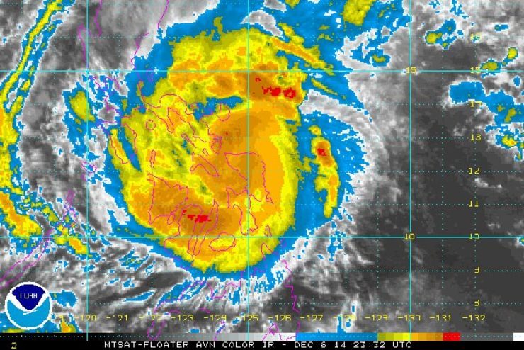
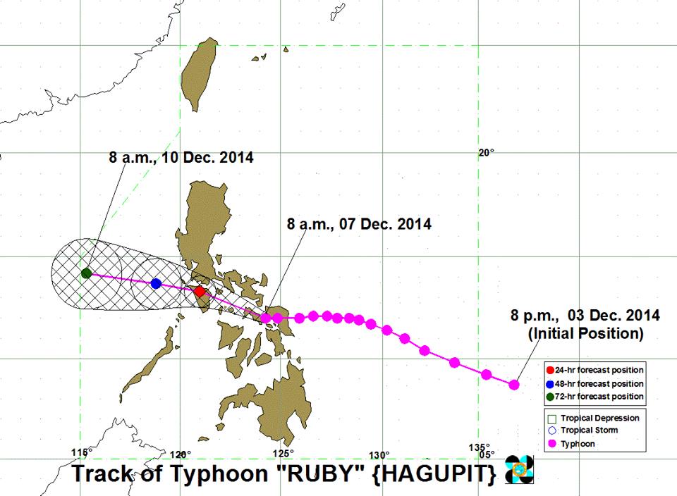
MANILA, Philippines (UPDATED) – Typhoon Ruby (Hagupit) made its second landfall over Cataingan, Masbate on Sunday, December 7, the state weather bureau said.
In its 11am bulletin, weather agency PAGASA said the typhoon is packing maximum sustained winds of 140 km/h and gusts of up to 170 km/h.
The typhoon, which is expected to move west northwest at 15 km/h, is currently located at 20 km east of Cataingan, Masbate.
Ruby first hit land at Dolores, Eastern Samar on Saturday night. It is expected to make its third landfall over Sibuyan Island between 8 and 10 pm Sunday night.
It will be associated with “strong winds, storm surge and heavy to torrential rainfall,” the bureau said.
Below is the list of areas placed under storm warning signals.

Signal Number 3
(Winds of 100-185 km/h expected in at least 18 hours)
- Masbate (including Ticao and Burias Islands)
- Sorsogon
- Albay
- Romblon
- Northern Samar
- Samar
Signal Number 2
(Winds of 61-100 km/h expected in at least 24 hours)
- Catanduanes
- Camarines Sur
- Camarines Norte
- Southern Quezon
- Batangas including Lubang Island
- Cavite
- Laguna
- Oriental Mindoro
- Occidental Mindoro
- Aklan
- Capiz
- Northern Cebu including Cebu City
- Bantayan Island
- Eastern Samar
- Biliran
- Leyte
- Southern Leyte
Signal Number 1
(Winds of at least 30-60 km/h expected in at least 36 hours)
- Rest of Quezon
- Rizal
- Pampanga
- Bulacan
- Nueva Ecija
- Zambales
- Bataan
- Northern Palawan
- Metro Manila
- Antique
- Iloilo
- Rest of Cebu
- Bohol
- Dinagat Province
- Siargao Island
Areas within Ruby’s 500-kilometer diameter can expect heavy to torrential rain (10 to greater than 30 mm/h), the bureau said.
By Monday morning, December 8, the storm is forecast to be 20 km southwest of Calapan City, or 150 km south of Science Garden, Quezon City.
It is expected to exit the Philippine Area of Responsibility by Wednesday, December 10.
In a briefing, National Disaster Risk Reduction and Management Council (NDRRMC) chief Alexander Pama said the agency does not have validated reports on casualties either in deaths or injuries.
A total of 146,875 families or 716,639 persons from Regions IV-A, IV-B, 5, 6, 7, 8, and CARAGA have been evacuated, Pama added.
Ruby is expected to exit the Philippine area of responsibility on Wednesday morning, December 10.
PAGASA will release its next bulletin at 5 pm on Sunday.
More misery
Typhoon Ruby tore apart homes and sent waves crashing through coastal communities across the eastern and central Philippines, creating more misery for millions following a barrage of deadly disasters.
Watch as Ruby hits the coasts of Albay.
The wind strength at landfall made Ruby the most powerful storm to hit the Philippines this year, exceeding a typhoon in July that killed more than 100 people.
“Many houses, especially in the coastal areas, were blown away by strong winds,” Stephanie Uy-Tan, the mayor of Catbalogan City, told Agence France-Presse by phone on Sunday morning.
“Trees and power lines were toppled, tin roofs were blown off and there is flooding.”
Fearful of a repeat of last year when Super Typhoon Yolanda (Haiyan) claimed more than 7,350 lives, the government undertook a massive evacuation effort ahead of Ruby that saw millions of people seek shelter.
However Ruby is forecast to take 3 days to cut across the Philippines, passing over mostly poor central regions, and authorities were still bracing for worst-case scenarios.
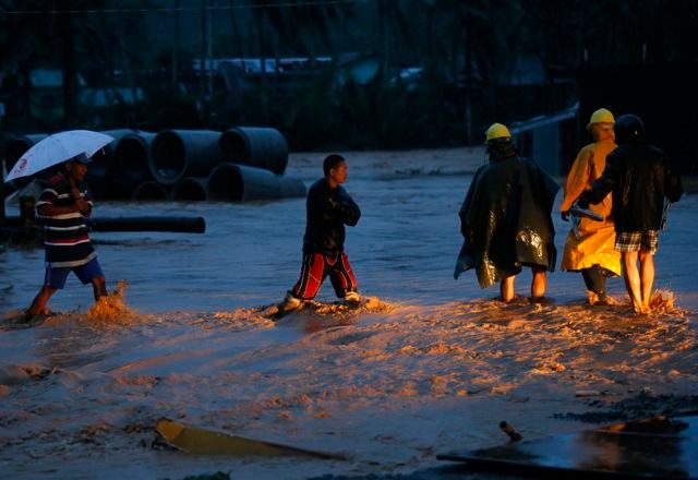
The government warned of storm surges up to 5 meters (16 feet) high in some areas, flash flooding, landslides and winds strong enough to tear apart even sturdy homes.
Tens of millions of people live in the typhoon’s path, including those in the central Philippines who are still struggling to recover from the devastation of Yolanda, which hit 13 months ago.
In Tacloban, one of the cities worst-hit by Yolanda, palm-thatch temporary houses built by aid agencies for survivors of last year’s typhoon had been torn apart, Vice Mayor Jerry Yaokasin told Agence France-Presse.
‘Better prepared’
However there was no repeat of the storm surges that did the most damage during Yolanda.
“There is a collective sigh of relief. The initial assessment is that there are no casualties. We were better prepared after Yolanda, up to 50,000 people were packed in evacuation centres,” Yaokasin said.
“But the transitional shelters made of nipa (palm thatch) were blown away. Our biggest challenge is how to provide for those who were displaced because of that,” he said.
In Bicol, hundreds of thousands of people were huddling in schools, churches and other official evacuation centers.
In Legazpi City, ocean sprays more than one meter high crashed above the city’s seawall and fierce winds roared on Sunday morning, ahead of the main typhoon front. – With reports from Agence France-Presse/Rappler.com
Add a comment
How does this make you feel?


There are no comments yet. Add your comment to start the conversation.