SUMMARY
This is AI generated summarization, which may have errors. For context, always refer to the full article.
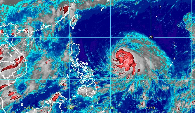
MANILA, Philippines – Chedeng (Guchol) strengthened from a tropical storm into a severe tropical storm on Wednesday evening, June 7, while staying far from Philippine landmass.
Chedeng’s maximum sustained winds increased from 85 kilometers per hour to 95 km/h, said the Philippine Atmospheric, Geophysical, and Astronomical Services Administration (PAGASA) in a press briefing past 11 pm on Wednesday.
Its gustiness is now up to 115 km/h from the previous 105 km/h.
Chedeng could intensify further in the next three days and become a typhoon by Thursday, June 8, according to PAGASA.
As of Wednesday evening, the severe tropical storm was located 1,220 kilometers east of southeastern Luzon, moving west northwest at only 10 km/h. It has no direct effect on the country due to its distance from land.
PAGASA said Chedeng remains unlikely to directly bring rain to any part of the country in the next three to five days.
The raising of tropical cyclone wind signals is also still unlikely, and coastal waters are not affected.
But Chedeng could enhance the southwest monsoon or habagat in the coming days. The weather bureau said the southwest monsoon may bring gusty conditions to the following areas:
Friday, June 9
- frequent gusts in Kalayaan Islands
- intermittent to occasional gusts in Visayas, Romblon, Oriental Mindoro, northern part of Palawan including Calamian and Cuyo islands, Surigao del Norte, Dinagat Islands, Camiguin
Saturday, June 10
- frequent gusts in Romblon and Kalayaan Islands
- intermittent to occasional gusts in Visayas, Calabarzon, Bicol, rest of Mimaropa, Camiguin, Dinagat Islands
As for potential monsoon rain, the timing and intensity would depend on how Chedeng enhances the southwest monsoon. The severe tropical storm’s movement and intensity will be taken into account.
If PAGASA sees “an increasing chance” of heavy monsoon rain in the next three days, a weather advisory would be released.
In the meantime, the southwest monsoon will still trigger rain showers and thunderstorms in Palawan on Thursday.
Other parts of the country will only have isolated rain showers or localized thunderstorms.

Chedeng’s latest forecast track shows it may move west northwest or northwest until mid-Friday, June 9, before turning toward the north and slowing down.
On Sunday, June 11, it could start speeding up as it heads north northeast or northeast.
It is projected to leave the Philippine Area of Responsibility late Sunday or early Monday, June 12.
Chedeng is the Philippines’ third tropical cyclone for 2023 and the first for June. PAGASA earlier estimated there would be one or two tropical cyclones during the month.
The weather bureau announced the start of the rainy season last Friday, June 2. – Rappler.com
Add a comment
How does this make you feel?


There are no comments yet. Add your comment to start the conversation.