SUMMARY
This is AI generated summarization, which may have errors. For context, always refer to the full article.
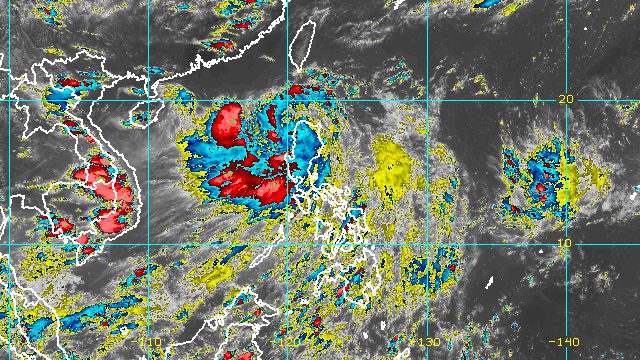
MANILA, Philippines – Severe Tropical Storm Florita (Ma-on) slightly weakened while crossing the northern part of Apayao on Tuesday afternoon, August 23, but it continued to trigger torrential rain.
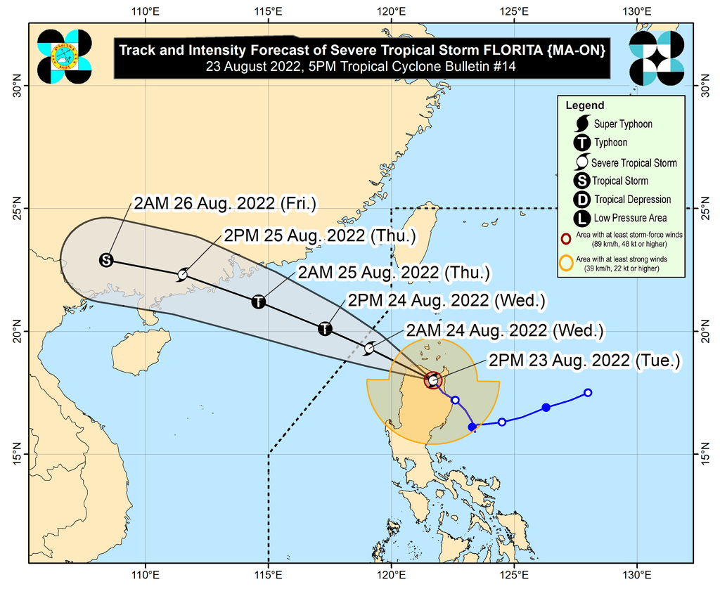
Florita’s maximum sustained winds decreased from 110 kilometers per hour to 100 km/h due to the “rugged terrain” of Northern Luzon, the Philippine Atmospheric, Geophysical, and Astronomical Services Administration (PAGASA) said in a briefing past 5 pm on Tuesday.
The severe tropical storm’s gustiness is up to 165 km/h.
Florita was last spotted in the vicinity of Kabugao, Apayao. It earlier made landfall in Maconacon, Isabela, at 10:30 am, then crossed Isabela and Cagayan.
PAGASA said the severe tropical storm is moving northwest at 20 km/h, and will continue to cross Apayao, followed by Ilocos Norte, before emerging over the West Philippine Sea on Tuesday evening.
Rain from Florita will persist in parts of Luzon. Several areas were already flooded on Tuesday.
Tuesday, August 23
Heavy to intense rain, with at times torrential rain
- Cagayan including Babuyan Islands
- Cordillera Administrative Region
- Ilocos Region
- Zambales
- Bataan
Moderate to heavy rain
- rest of Cagayan Valley
- Metro Manila
- Isabela
- Tarlac
- Pampanga
- Cavite
Light to moderate rain, with at times heavy rain
- rest of Central Luzon
- rest of Calabarzon
Wednesday, August 24
Moderate to heavy rain, with at times intense rain
- Ilocos Region
- Benguet
- Abra
Light to moderate rain, with at times heavy rain
- rest of Cordillera Administrative Region
- Zambales
- Bataan
Florita also continues to enhance the southwest monsoon or hanging habagat, which is causing rain in Mimaropa and Western Visayas.
These areas remain under tropical cyclone wind signals as of 5 pm on Tuesday:
Signal No. 3
Storm-force winds (89 to 117 km/h), moderate to significant threat to life and property
- Ilocos Norte
- Apayao
- southern part of Babuyan Islands (Camiguin Island, Fuga Island, Dalupiri Island)
- mainland Cagayan
Signal No. 2
Gale-force winds (62 to 88 km/h), minor to moderate threat to life and property
- Ifugao
- Mountain Province
- Kalinga
- Abra
- Ilocos Sur
- Isabela
- rest of Babuyan Islands
Signal No. 1
Strong winds (39 to 61 km/h), minimal to minor threat to life and property
- La Union
- eastern part of Pangasinan (Umingan, San Fabian, Sison, Pozorrubio, San Jacinto, Laoac, Binalonan, San Manuel, Asingan, Tayug, Santa Maria, San Quintin, Natividad, San Nicolas)
- Benguet
- Nueva Vizcaya
- Quirino
- northern part of Nueva Ecija (Carranglan, Lupao, San Jose City, Pantabangan)
- northern and central parts of Aurora (Maria Aurora, Dipaculao, Dinalungan, Casiguran, Dilasag)
PAGASA added that gusts may be experienced in these areas until Wednesday, August 24:
- Metro Manila
- Calabarzon
- Bicol
- Zambales
- Bataan
- Tarlac
- Nueva Ecija
- Pampanga
- Bulacan
- Occidental Mindoro
- Oriental Mindoro
- Marinduque
- Romblon
- remaining areas in Pangasinan and Aurora not under wind signals
- Northern Samar
- Antique
- Aklan

The weather bureau also issued a new gale warning at 5 pm, covering the following seaboards:
- seaboards of Northern Luzon – rough to high seas, with waves 3.5 to 7 meters high
- western seaboard of Northern Luzon as well as eastern and western seaboards of Central Luzon – rough to very rough seas, with waves 2.8 to 4.5 meters high
- seaboards of Southern Luzon and western seaboard of Visayas – rough seas, with waves 2.8 to 4 meters high
- remaining seaboards of Southern Luzon and Visayas – moderate to rough seas, with waves 1.2 to 2.8 meters high
The weather bureau said rough to high seas are risky for all vessels, while small vessels should not sail if seas are rough to very rough.
Moderate to rough seas may also be risky for small vessels.
Florita, the country’s sixth tropical cyclone for 2022, is expected to leave the Philippine Area of Responsibility on Wednesday morning.
Over the West Philippine Sea, Florita might re-intensify and become a typhoon by Wednesday afternoon. – Rappler.com
Add a comment
How does this make you feel?


There are no comments yet. Add your comment to start the conversation.