SUMMARY
This is AI generated summarization, which may have errors. For context, always refer to the full article.

MANILA, Philippines – While it remains “less likely” for tropical cyclone wind signals to be raised due to Severe Tropical Storm Inday (Muifa), the weather bureau is now saying this would be possible if the tropical cyclone’s track shifts further west and/or its winds cover a larger area.
Parts of extreme Northern Luzon could have wind signals if that happens, the Philippine Atmospheric, Geophysical, and Astronomical Services Administration (PAGASA) said in a bulletin issued at 5 am on Saturday, September 10.
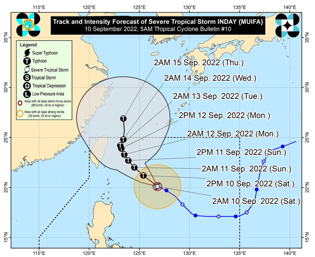
Inday was last spotted 495 kilometers east of Basco, Batanes, moving west northwest at 20 kilometers per hour (km/h). It is not seen to make landfall.
The severe tropical storm already has maximum sustained winds of 110 km/h and gustiness of up to 135 km/h after continuously intensifying on Friday, September 9. It is projected to strengthen into a typhoon on Saturday.
So far, Inday’s winds extend outwards up to 260 kilometers from its center.
In terms of rainfall, Inday is still unlikely to directly bring heavy rain to the Philippines. But the trough or extension of the severe tropical storm could cause scattered rain showers and thunderstorms in these areas on Saturday:
- Calabarzon
- Mimaropa
- Bicol
- Bataan
- Zambales
- Western Visayas
PAGASA reiterated that flash floods and landslides may occur during periods of moderate to heavy rain.
The rest of the country will only have localized thunderstorms, unrelated to Inday’s trough.
The severe tropical storm could also trigger moderate to rough seas in Batanes (waves 2 to 4 meters high) and Babuyan Islands (waves 1.5 to 3 meters high) on Saturday. Conditions may be risky for small vessels.
PAGASA expects Inday to move generally northwest over the Philippine Sea from Saturday to Monday, September 12, gradually slowing down as it heads for the sea east of Taiwan.
With Inday likely slowing down, it could become almost stationary by Tuesday, September 13.
Inday is also expected to intensify over the Philippine Sea until Sunday, September 11, or Monday.
“However, the slightly cooler waters east of Taiwan and the forecast slowdown period over this sea area may kick-start a weakening trend beginning on Monday or Tuesday,” added PAGASA.
Finally, Inday could leave the Philippine Area of Responsibility (PAR) and pass close to Japan’s Miyako Islands or Yaeyama Islands by late Tuesday or early Wednesday, September 14.
Inday is the Philippines’ ninth tropical cyclone for 2022 and the first for September.
PAGASA expects 7 to 11 tropical cyclones to enter or develop inside PAR from September 2022 to February 2023. Per month, these are the weather bureau’s estimates:
- September 2022 – 2 or 3
- October 2022 – 2 to 4
- November 2022 – 2 or 3
- December 2022 – 1 or 2
- January 2023 – 0 or 1
- February 2023 – 0 or 1
– Rappler.com
Add a comment
How does this make you feel?


There are no comments yet. Add your comment to start the conversation.