SUMMARY
This is AI generated summarization, which may have errors. For context, always refer to the full article.
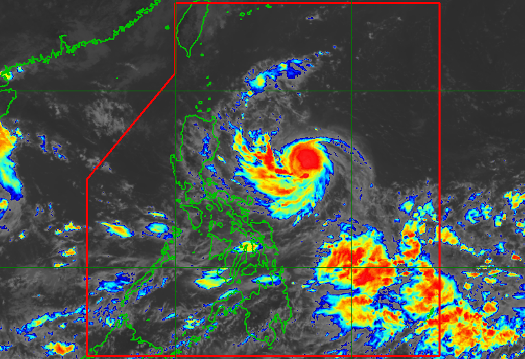
MANILA, Philippines – Karding (Noru) strengthened from a tropical storm into a severe tropical storm at 8 am on Saturday, September 24, as it continued heading for Central Luzon and Northern Luzon.
Karding’s maximum sustained winds increased from 85 kilometers per hour to 100 km/h, the Philippine Atmospheric, Geophysical, and Astronomical Services Administration (PAGASA) said in a briefing past 11 am on Saturday. Its gustiness is now up to 125 km/h from the previous 105 km/h.
Karding is now projected to intensify into a typhoon before it makes landfall, and is “highly likely” to remain a typhoon while crossing land.
Karding was last spotted 660 kilometers east southeast of Tuguegarao City, Cagayan, or 595 kilometers east of Casiguran, Aurora, on Saturday morning.
The severe tropical storm maintained its west southwest movement, but accelerated to a speed of 25 km/h from the previous 15 km/h.
It is moving toward the east coast of Aurora or Isabela, where it is likely to make landfall on Sunday morning or afternoon, September 25. It will then cross Central Luzon or Northern Luzon before emerging over the West Philippine Sea late Sunday evening or early Monday morning, September 26.
Signal No. 2 was raised for the first time at 11 am on Saturday, giving affected areas 24 hours to prepare.
Many other areas were placed under Signal No. 1, including Metro Manila.
Here is the full list of places under tropical cyclone wind signals as of 11 am:
Signal No. 2
Gale-force winds (62 to 88 km/h), minor to moderate threat to life and property
- southeastern part of Isabela (Dinapigue)
- northern part of Aurora (Dinalungan, Casiguran, Dilasag)
- Polillo Islands
Signal No. 1
Strong winds (39 to 61 km/h), minimal to minor threat to life and property
- southern part of Cagayan (Peñablanca, Iguig, Tuguegarao City, Enrile, Solana, Tuao, Piat, Amulung, Rizal)
- rest of Isabela
- Quirino
- Nueva Vizcaya
- southern part of Apayao (Conner)
- Abra
- Kalinga
- Mountain Province
- Ifugao
- Benguet
- southern part of Ilocos Norte (Nueva Era, Badoc, Pinili, Banna, Batac City, Currimao, Paoay, Marcos)
- Ilocos Sur
- La Union
- Pangasinan
- rest of Aurora
- Nueva Ecija
- Tarlac
- Bulacan
- Pampanga
- Zambales
- Bataan
- Metro Manila
- northern and central parts of Quezon (Tagkawayan, Lopez, Guinayangan, Gumaca, Pitogo, Unisan, Agdangan, Padre Burgos, Pagbilao, Tayabas City, Lucban, Sampaloc, Mauban, Atimonan, Plaridel, Perez, Alabat, Quezon, Calauag, Lucena City, General Nakar, Real, Infanta)
- Rizal
- Laguna
- Cavite
- northern part of Batangas (Malvar, Balete, Tanauan City, Santo Tomas, Talisay, Laurel)
- Camarines Norte
- northern and eastern parts of Camarines Sur (Del Gallego, Ragay, Lupi, Sipocot, Siruma, Tinambac, Goa, Lagonoy, Garchitorena, Caramoan, Presentacion, San Jose)
- northern part of Catanduanes (Pandan, Caramoran, Bagamanoc, Panganiban, Viga, Gigmoto)
Since Karding is now expected to become a typhoon before landfall, the highest possible wind signal is Signal No. 4.
PAGASA also updated its rainfall forecast for Karding. It announced more areas where rain is expected, and is now warning of torrential rain from the severe tropical storm.
Saturday evening, September 24, until early Sunday morning, September 25
Light to moderate rain, with at times heavy rain
- Batanes
- Cagayan
- Isabela
- northern part of Aurora
- Catanduanes
- Camarines Norte
- Camarines Sur
Rest of Sunday, September 25, until early Monday morning, September 26
Heavy to intense rain, with at times torrential rain
- southern part of Isabela
- Quirino
- Nueva Vizcaya
- Benguet
- La Union
- Pangasinan
- Aurora
- Nueva Ecija
- Tarlac
- northern part of Zambales
Moderate to heavy rain, with at times intense rain
- rest of Central Luzon
Moderate to heavy rain
- Cagayan
- Ilocos Norte
- Ilocos Sur
- Calabarzon
- Metro Manila
- rest of Isabela
- rest of Cordillera Administrative Region
Floods and landslides are possible.
Karding will also enhance the southwest monsoon or hanging habagat, which may bring occasional rain to most of Southern Luzon and the Visayas, especially their western sections, beginning Saturday or Sunday.
PAGASA added that the northeasterlies and the approaching severe tropical storm could cause moderate to rough seas, with waves 1.5 to 3.5 meters high, in the seaboards of Northern Luzon on Saturday.
On Sunday, the seaboards of Northern Luzon and the eastern seaboard of Central Luzon are expected to have rough to very rough seas, with waves 2.8 to 6.5 meters high.
The expected sea conditions during the weekend would be risky for most vessels.
Karding may leave the Philippine Area of Responsibility (PAR) on Monday.

Karding is the Philippines’ 11th tropical cyclone for 2022.
It is also the third tropical cyclone for September, after Typhoon Inday (Muifa) and Super Typhoon Josie (Nanmadol). Inday and Josie did not make landfall in the country.
PAGASA expects 7 to 11 tropical cyclones to enter or develop inside PAR from September 2022 to February 2023. Per month, these are the weather bureau’s estimates:
- September 2022 – 2 or 3
- October 2022 – 2 to 4
- November 2022 – 2 or 3
- December 2022 – 1 or 2
- January 2023 – 0 or 1
- February 2023 – 0 or 1
– Rappler.com
Add a comment
How does this make you feel?


There are no comments yet. Add your comment to start the conversation.