SUMMARY
This is AI generated summarization, which may have errors. For context, always refer to the full article.
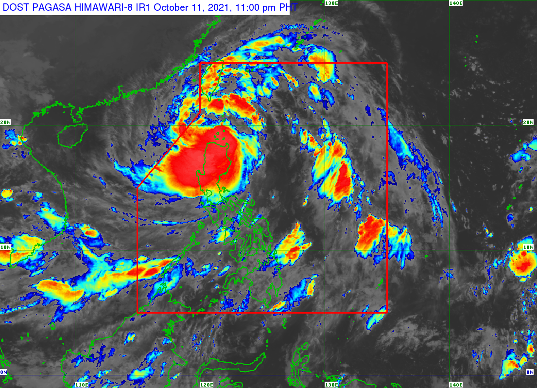
Severe Tropical Storm Maring (Kompasu) made landfall in Fuga Island at 8:10 pm on Monday, October 11, continuing to batter Northern Luzon with massive rainfall that has triggered floods.
Fuga Island is part of the Babuyan Group of Islands and is under the municipality of Aparri in the province of Cagayan.
As of 10 pm on Monday, Maring was over the coastal waters of Aparri, moving west at a slower 15 kilometers per hour from the previous 25 km/h.
The Philippine Atmospheric, Geophysical, and Astronomical Services Administration (PAGASA) said Maring will continue to cross the Luzon Strait, and then the West Philippine Sea.
The severe tropical storm maintained its strength late Monday evening, with maximum sustained winds of 95 km/h. But its gustiness increased from 115 km/h to 145 km/h. (READ: FAST FACTS: Tropical cyclones, rainfall advisories)
In a series of Facebook posts on Monday evening, the Cagayan Provincial Information Office said operations were ongoing to rescue residents in flooded areas. Affected municipalities include Buguey and Santa Teresita.
Flooding was also reported in the Ilocos Region.
PAGASA warned that the rain is expected to continue until Tuesday, which may mean more floods and landslides.
Heavy to intense rain, with at times torrential rain
- Batanes
- northern part of Cagayan including Babuyan Islands
- Cordillera Administrative Region
- Ilocos Region
Moderate to heavy rain, with at times intense rain
- rest of Cagayan
Light to moderate rain, with at times heavy rain
- rest of Cagayan Valley
- Central Luzon
Rain from the southwest monsoon or hanging habagat enhanced by Maring will persist on Tuesday as well. Flash floods and landslides could still occur.
Moderate to heavy rain
- Western Visayas
- Occidental Mindoro
- Palawan
Light to moderate rain, with at times heavy rain
- rest of Visayas
- Oriental Mindoro
- Zamboanga Peninsula
The same areas remain under tropical cyclone wind signals as of 11 pm on Monday.
Signal No. 2 (damaging gale-force to storm-force winds)
- Batanes
- Cagayan including Babuyan Islands
- northern part of Isabela (Palanan, Divilacan, Maconacon, Ilagan City, Tumauini, Cabagan, San Pablo, Santa Maria, Santo Tomas, Delfin Albano, Quirino, Gamu, Roxas, Mallig, Quezon)
- Apayao
- Kalinga
- Mountain Province
- Abra
- Ilocos Norte
- Ilocos Sur
Signal No. 1 (strong winds)
- rest of Isabela
- Nueva Vizcaya
- Quirino
- Ifugao
- Benguet
- La Union
- Pangasinan
- Aurora
- Nueva Ecija
- Tarlac
- Zambales
- Pampanga
- Bulacan
- northern part of Bataan (Samal, Morong, Dinalupihan, Abucay, Orani, Hermosa)
- northern part of Quezon (General Nakar, Infanta) including Polillo Islands
PAGASA added that gusty conditions are likely in other areas on Tuesday due to Maring’s “expansive wind field” and the enhanced southwest monsoon.
- rest of Luzon
- Visayas
- Dinagat Islands
- Surigao del Norte
- Agusan del Norte
- Misamis Oriental
- Misamis Occidental
- Camiguin
- Zamboanga del Norte
The weather bureau also reiterated that there is a “minimal to moderate risk” of life-threatening storm surges up to 1 meter high on Tuesday.
“Rising seawater along with the high waves from the shoreline moving inland may cause flooding in the low-lying coastal localities of Batanes, Cagayan including Babuyan Islands, and Ilocos Norte,” it said.
Sea travel remains dangerous.
Rough to high seas (waves 2.8 to 7.5 meters high)
Conditions risky for all vessels
- seaboards of areas under Signal Nos. 1 and 2
Rough to very rough seas (waves 2.8 to 4.5 meters high)
Small vessels advised not to sail, larger vessels alerted against big waves
- western seaboard of Central Luzon
- seaboards of Southern Luzon and Visayas
- western, eastern, and northern seaboards of Mindanao
Moderate to rough seas (waves 1.2 to 2.5 meters high)
Conditions risky for small vessels
- remaining seaboards of the country
Maring is likely to leave the Philippine Area of Responsibility (PAR) on Tuesday morning.
After its exit, it will head west for Hainan, China, where it could make landfall on Wednesday evening, October 13.
PAGASA said Maring is projected to gradually intensify over the next 36 hours, but it is “becoming less likely to reach typhoon category” prior to its possible landfall in Hainan.
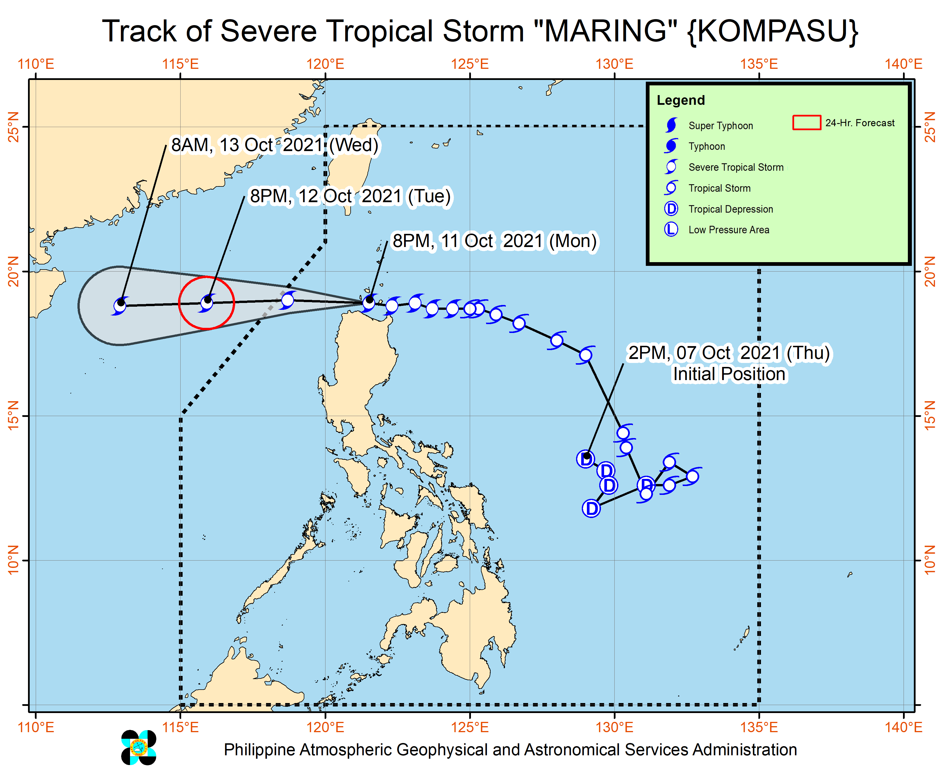
Maring is the Philippines’ 13th tropical cyclone for 2021 and the second for October.
On Sunday morning, October 10, Maring had completed its merger with the remnant low that was formerly Tropical Depression Nando. The two tropical cyclones had interacted over the Philippine Sea, resulting in the merger.
Nando, the Philippines’ 14th tropical cyclone for 2021, had no impact on weather in the country.
An average of 20 tropical cyclones form within or enter PAR each year. (READ: LIST: PAGASA’s names for tropical cyclones in 2021)
These are PAGASA’s latest estimates for the next six months:
2021
- October – 2 or 3
- November – 2 or 3
- December – 1 or 2
2022
- January – 0 or 1
- February – 0 or 1
- March – 0 or 1
The weather bureau is also monitoring the possible emergence of La Niña in the fourth quarter of 2021. – Rappler.com
Add a comment
How does this make you feel?


There are no comments yet. Add your comment to start the conversation.