SUMMARY
This is AI generated summarization, which may have errors. For context, always refer to the full article.
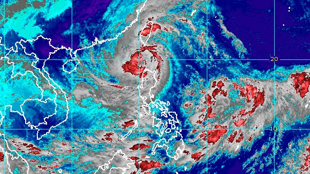
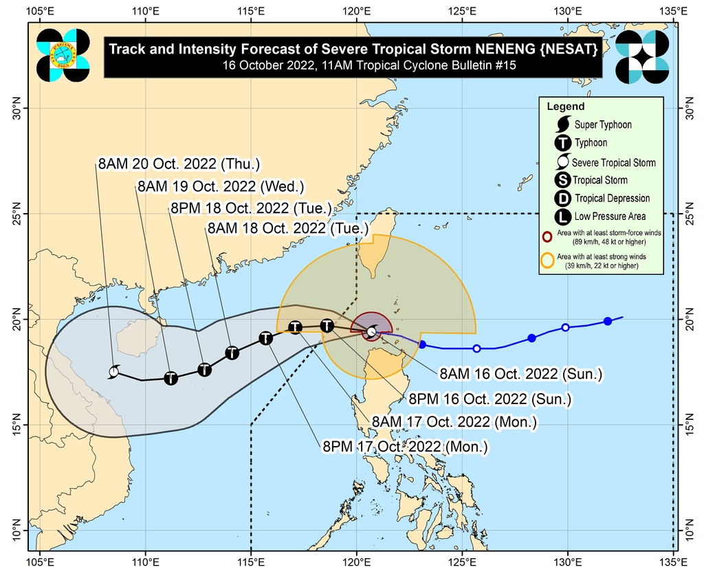
MANILA, Philippines – Severe Tropical Storm Neneng (Nesat) intensified further as it moved away from Cagayan province’s Babuyan Islands late Sunday morning, October 16.
Neneng’s maximum sustained winds increased from 95 kilometers per hour to 100 km/h, said the Philippine Atmospheric, Geophysical, and Astronomical Services Administration (PAGASA) in its 11 am bulletin on Sunday. The severe tropical storm’s gustiness is up to 125 km/h.
Neneng was last spotted 115 kilometers west northwest of Calayan, Cagayan, moving west at 25 km/h.
The severe tropical storm is expected to leave the Philippine Area of Responsibility (PAR) late Sunday afternoon or evening. Also during this period, it could strengthen into a typhoon.
Neneng earlier made landfall in Calayan Island at 3:50 am on Sunday.
Though the severe tropical storm is moving away from land, there will still be rain on Sunday.
Until early Sunday afternoon
Moderate to heavy rain, with at times intense rain
- Apayao
- Ilocos Norte
- Ilocos Sur
- Babuyan Islands
Light to moderate rain, with at times heavy rain
- Batanes
- northern part of Cagayan
- rest of Cordillera Administrative Region
- rest of Ilocos Region
Rest of Sunday
Light to moderate rain, with at times heavy rain
- Ilocos Norte
- Ilocos Sur
At the height of Neneng’s onslaught, it dumped torrential rain in parts of Northern Luzon, triggering floods.
PAGASA also said Neneng’s trough or extension “and the convergence of its circulation with the southwesterly winds induced by the severe tropical storm” could bring occasional rain to the following areas:
- western part of Mimaropa
- western part of Visayas
- northern and western parts of Mindanao
Tropical cyclone wind signals remain in effect as of 11 am on Sunday.
Signal No. 3
Storm-force winds (89 to 117 km/h), moderate to significant threat to life and property
- southern part of Batanes (Basco, Mahatao, Uyugan, Ivana, Sabtang)
- Babuyan Islands
Signal No. 2
Gale-force winds (62 to 88 km/h), minor to moderate threat to life and property
- rest of Batanes
- rest of Cagayan
- Apayao
- northern part of Abra (Tineg, Lacub, Lagayan)
- Ilocos Norte
Signal No. 1
Strong winds (39 to 61 km/h), minimal to minor threat to life and property
- northern and central parts of Isabela (Santa Maria, San Pablo, Maconacon, Divilacan, Palanan, Ilagan City, Tumauini, Cabagan, Santo Tomas, Quezon, Delfin Albano, Mallig, Quirino, Gamu, Roxas, San Mariano, Benito Soliven, Naguilian, Burgos, Reina Mercedes, San Manuel, Aurora, Luna, Cabatuan, San Mateo, Dinapigue, Cauayan City)
- Kalinga
- rest of Abra
- Mountain Province
- northern part of Ifugao (Aguinaldo, Alfonso Lista, Mayoyao, Hungduan, Banaue)
- northern and central parts of Ilocos Sur (Sinait, Cabugao, San Juan, Magsingal, Santo Domingo, San Ildefonso, San Vicente, Santa Catalina, Bantay, Vigan City, Santa, Caoayan, Narvacan, Nagbukel, Santa Maria, San Esteban, Santiago, Burgos, Banayoyo, Lidlidda, San Emilio, Quirino, Gregorio del Pilar, Galimuyod, Candon City, Santa Lucia, Salcedo, Cervantes, Suyo, Sigay, Santa Cruz)
PAGASA added that there may be occasional gusts in most of Southern Luzon and the Visayas, as well as the eastern parts of Central Luzon, due to the induced southwesterly winds.
Meanwhile, seas remain rough to very rough due to Neneng and the northeasterly surface windflow. The gale warning in effect since 5 am on Sunday covers the following seaboards:
- seaboards of Northern Luzon (Batanes, Cagayan, Ilocos Norte) – waves 3.4 to 5.5 meters high
- eastern and western seaboards of Northern Luzon (Isabela, Ilocos Sur) – waves 3.1 to 4.5 meters high
- western seaboard of Northern Luzon (La Union, Pangasinan) – waves 2.8 to 4.5 meters high
PAGASA advised fishing boats and other small vessels not to sail, and larger vessels to watch out for big waves.
The surge of the northeasterly surface windflow and Neneng may also cause moderate to rough seas in the eastern and western seaboards of Central Luzon as well as the eastern seaboard of Southern Luzon. Waves could be 2 to 3.5 meters high, making conditions risky for small vessels.
Neneng is the Philippines’ 14th tropical cyclone for 2022 and the second for October.
PAGASA expects 5 to 9 tropical cyclones to enter or develop inside PAR from October 2022 to March 2023. Per month, these are the weather bureau’s estimates:
- October 2022 – 2 to 4
- November 2022 – 2 or 3
- December 2022 – 1 or 2
- January 2023 – 0 or 1
- February 2023 – 0 or 1
- March 2023 – 0 or 1
– Rappler.com
Add a comment
How does this make you feel?


There are no comments yet. Add your comment to start the conversation.