SUMMARY
This is AI generated summarization, which may have errors. For context, always refer to the full article.
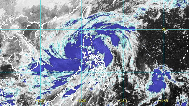
MANILA, Philippines – Severe Tropical Storm Paeng (Nalgae) maintained its strength while crossing the northern part of Cavite province early Saturday evening, October 29, still bringing heavy rain and strong winds.
Paeng was already in the vicinity of General Mariano Alvarez, Cavite, at 7 pm on Saturday, continuing its northwest movement at 20 kilometers per hour (km/h).
The Philippine Atmospheric, Geophysical, and Astronomical Services Administration (PAGASA) said in its 8 pm bulletin that Paeng will cross the southern part of Bataan after passing through Cavite.
So far, the severe tropical storm has made landfall five times, all on Saturday:
- Virac, Catanduanes – 1:10 am
- Caramoan, Camarines Sur – 1:40 am
- Buenavista, Quezon – 6 am
- Santa Cruz, Marinduque – 8:40 am
- Sariaya, Quezon – 1:40 pm
After hitting Quezon for a second time, Paeng crossed Laguna, then Cavite.
Even before its landfalls in Luzon, however, Paeng already wreaked havoc in parts of Mindanao and the Visayas.
As of early Saturday evening, the severe tropical storm still had maximum sustained winds of 95 km/h and gustiness of up to 160 km/h. It is likely to maintain its strength while crossing land and intensify once it emerges over the West Philippine Sea.
PAGASA warned that rain in parts of Luzon may still be torrential at times on Saturday evening. The weather will only begin to improve when Paeng moves away on Sunday, October 30.
Saturday evening, October 29
Heavy to intense rain, with at times torrential rain
- Metro Manila
- Calabarzon
- Bataan
- Zambales
- Marinduque
- Occidental Mindoro
- Oriental Mindoro
- northern part of Palawan including Calamian and Cuyo Islands
Moderate to heavy rain, with at times intense rain
- Camarines Norte
- Camarines Sur
- Isabela
- Aurora
- rest of Mimaropa
- Ilocos Region
- Cordillera Administrative Region
Light to moderate rain, with at times heavy rain
- rest of Luzon
- rest of Visayas
Sunday, October 30
Moderate to heavy rain, with at times intense rain
- Zambales
- Bataan
- Ilocos Region
Light to moderate rain, with at times heavy rain
- Metro Manila
- Cordillera Administrative Region
- Mimaropa
- Calabarzon
- rest of Central Luzon
Below are the areas covered by tropical cyclone wind signals as of 8 pm on Saturday.
Signal No. 3
Storm-force winds (89 to 117 km/h), moderate to significant threat to life and property
- central and southern parts of Zambales (San Marcelino, Subic, Olongapo City, Castillejos, San Antonio, San Narciso, San Felipe, Cabangan, Botolan)
- Bataan
- southern part of Bulacan (Hagonoy, Paombong, Malolos City, Bulacan, Obando, Meycauayan City)
- western part of Pampanga (Masantol, Macabebe, Sasmuan, Lubao, Floridablanca, Porac)
- Metro Manila
- southwestern part of Quezon (Tayabas City, Lucena City, Lucban, Sariaya, Candelaria, Dolores, Tiaong, San Antonio)
- Laguna
- Batangas
- Cavite
- Rizal
- northwestern part of Occidental Mindoro (Paluan, Abra de Ilog) including Lubang Islands
- northwestern part of Oriental Mindoro (San Teodoro, Puerto Galera, Baco, Calapan City)
Signal No. 2
Gale-force winds (62 to 88 km/h), minor to moderate threat to life and property
- Pangasinan
- southern part of Aurora (San Luis, Baler, Dingalan, Maria Aurora)
- Tarlac
- Nueva Ecija
- rest of Bulacan
- rest of Pampanga
- rest of Zambales
- central part of Oriental Mindoro (Socorro, Gloria, Bansud, Victoria, Bongabong, Pinamalayan, Pola, Naujan)
- central part of Occidental Mindoro (Sablayan, Mamburao, Santa Cruz)
- Marinduque
- northern part of Romblon (Concepcion, Corcuera, Banton)
- western and central parts of Camarines Norte (Santa Elena, Labo, Capalonga, Jose Panganiban, Paracale, San Vicente, San Lorenzo Ruiz, Daet, Vinzons, Talisay)
- western part of Camarines Sur (Del Gallego, Ragay)
- rest of Quezon including Polillo Islands
Signal No. 1
Strong winds (39 to 61 km/h), minimal to minor threat to life and property
- La Union
- Kalinga
- Abra
- Benguet
- Ifugao
- Mountain Province
- Ilocos Sur
- Isabela
- Nueva Vizcaya
- Quirino
- rest of Aurora
- Catanduanes
- Albay
- Sorsogon
- Masbate including Ticao and Burias Islands
- rest of Romblon
- rest of Camarines Sur
- rest of Camarines Norte
- rest of Occidental Mindoro
- rest of Oriental Mindoro
- northern part of Palawan (El Nido, Taytay, Dumaran, Araceli, Roxas, San Vicente) including Calamian and Cuyo Islands
- western part of Northern Samar (Lope de Vega, Rosario, Biri, San Isidro, Capul, San Vicente, Victoria, Lavezares, San Antonio, Mondragon, San Jose, Pambujan, Catarman, San Roque, Allen, Bobon, Silvino Lobos)
- northwestern part of Samar (Calbayog City, Santa Margarita, Gandara, Pagsanghan, Tarangnan, Santo Niño, Almagro, Tagapul-an)
- northwestern part of Leyte (Calubian, San Isidro)
- northern part of Biliran (Maripipi, Kawayan, Almeria, Naval, Culaba)
- extreme northern part of Cebu (Medellin, Daanbantayan) including Bantayan Islands
- northern part of Negros Occidental (Sagay City, Cadiz City, Escalante City, Manapla, Enrique B. Magalona, Victorias City, Silay City, Talisay City, Murcia, Bacolod City, Bago City, Pulupandan, San Carlos City, Salvador Benedicto, Calatrava, Toboso, Valladolid, La Carlota City)
- Guimaras
- Capiz
- Iloilo
- Aklan
- Antique
Meanwhile, the surge of the northeast monsoon or hanging amihan enhanced by Paeng is bringing strong winds to these areas:
- Batanes
- Babuyan Islands
- northern and eastern parts of mainland Cagayan
- Ilocos Norte
- northern part of Apayao

PAGASA also warned that there is a minimal to moderate risk of storm surges up to 2 meters high, which may cause floods in the “low-lying and exposed coastal areas” of the following:
- eastern part of Quezon
- Cavite
- Pampanga
- Bulacan
- Metro Manila
- Bataan
The gale warning issued at 5 pm on Saturday remains in effect.
- seaboards of Central Luzon and Southern Luzon and western seaboard of Northern Luzon (Aurora, Zambales, Bataan, Pampanga, Bulacan, Metro Manila, Cavite, Batangas, Quezon including Polillo Islands, Occidental Mindoro including Lubang Islands, Oriental Mindoro, Marinduque, Romblon, Camarines Norte, Camarines Sur, Catanduanes, Albay, Sorsogon, Masbate including Burias and Ticao Islands, Ilocos Norte, Ilocos Sur, La Union, Pangasinan) – very rough to high seas, waves 4.5 to 8 meters high
- northern and eastern seaboards of Northern Luzon (Batanes, Cagayan including Babuyan Islands, Isabela) – very rough seas, waves 4.5 to 6 meters high
- seaboards of Visayas and Palawan (Aklan, Antique, Capiz, Iloilo, Guimaras, Negros Occidental, Negros Oriental, Cebu, Bohol, Siquijor, Northern Samar, Samar, Eastern Samar, Biliran, Palawan including Calamian, Cuyo, Cagayancillo, and Kalayaan Islands) – rough to very rough seas, waves 4 to 5.5 meters high
- eastern seaboards of Visayas and Mindanao (Leyte, Southern Leyte, Surigao del Norte including Siargao and Bucas Grande Islands, Dinagat Islands, Surigao del Sur, eastern coast of Davao Oriental) – rough to very rough seas, waves 2.8 to 4.5 meters high
“Rough to high sea conditions are risky for all types of sea vessels. Mariners are advised to remain in port or take shelter in port until winds and waves subside,” PAGASA said.
Paeng may leave the Philippine Area of Responsibility (PAR) on Monday, October 31. It is the country’s 16th tropical cyclone for 2022 and the fourth for October.
Aside from Paeng, the weather bureau is monitoring a tropical depression outside PAR.
The tropical depression was last spotted 1,460 kilometers east of northeastern Mindanao on Saturday afternoon, slowly moving west southwest.
It still has maximum sustained winds of 45 km/h and gustiness of up to 55 km/h.
PAGASA said the tropical depression may enter PAR on Monday or on Tuesday, November 1. It may not directly affect the Philippines, though the public should still monitor developments. – Rappler.com
Add a comment
How does this make you feel?


There are no comments yet. Add your comment to start the conversation.