SUMMARY
This is AI generated summarization, which may have errors. For context, always refer to the full article.
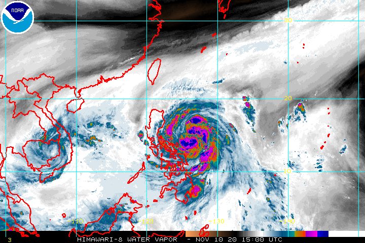
Severe Tropical Storm Ulysses (Vamco) started heading for Southern Luzon late Tuesday evening, November 10, while maintaining its strength.
The Philippine Atmospheric, Geophysical, and Astronomical Services Administration (PAGASA) said in a bulletin released past 11 pm on Tuesday that Ulysses is already 250 kilometers east northeast of Virac, Catanduanes.
The severe tropical storm continues to move west northwest at a relatively fast 30 kilometers per hour (km/h). (READ: FAST FACTS: Tropical cyclones, rainfall advisories)
Ulysses still has maximum sustained winds of 95 km/h and gustiness of up to 115 km/h.
But PAGASA warned that Ulysses may intensify into a typhoon within 12 to 24 hours and reach its peak intensity of 130 to 155 km/h before landfall.
Several areas, including Metro Manila, were upgraded to Signal No. 2 as of 11 pm on Tuesday. Check the latest list below.
Signal No. 2
- central and southern parts of Aurora (Dipaculao, Maria Aurora, Baler, San Luis, Dingalan)
- southeastern part of Nueva Ecija (Bongabon, Laur, General Tinio, Gapan City, Peñaranda, Gabaldon)
- northern and eastern parts of Bulacan (Meycauayan City, Obando, Marilao, Bocaue, Pandi, Bustos, San Rafael, San Ildefonso, San Miguel, Angat, Santa Maria, San Jose del Monte City, Norzagaray, Doña Remedios Trinidad)
- Metro Manila
- Rizal
- Laguna
- Quezon including Polillo Island
- Marinduque
- Camarines Norte
- Camarines Sur
- Catanduanes
- Albay
- Sorsogon
- Ticao and Burias Islands
Signal No. 1
- Isabela
- Quirino
- Nueva Vizcaya
- Kalinga
- Mountain Province
- Ifugao
- Benguet
- Abra
- Ilocos Sur
- La Union
- Pangasinan
- rest of Aurora
- rest of Nueva Ecija
- Tarlac
- Zambales
- Bataan
- Pampanga
- rest of Bulacan
- Cavite
- Batangas
- Occidental Mindoro including Lubang Island
- Oriental Mindoro
- Romblon
- rest of Masbate
- Northern Samar
- northern part of Samar (Santo Niño, Almagro, Tagapul-an, Tarangnan, Calbayog City, Santa Margarita, Gandara, Pagsanghan, San Jorge, San Jose de Buan, Matuguinao)
- northern part of Eastern Samar (Maslog, Dolores, Oras, San Policarpo, Arteche, Jipapad)
PAGASA said areas under Signal No. 2 should brace for damaging gale-force to storm-force winds, while those under Signal No. 1 will have strong breeze to near gale conditions during the passage of Ulysses.
But once Ulysses intensifies into a typhoon, Signal No. 3 could be raised over parts of Bicol, and eventually over Metro Manila as well as parts of Calabarzon and Central Luzon.
In the rest of Northern Luzon, there will also be strong to gale-force winds due to the surge of the northeast monsoon or hanging amihan.
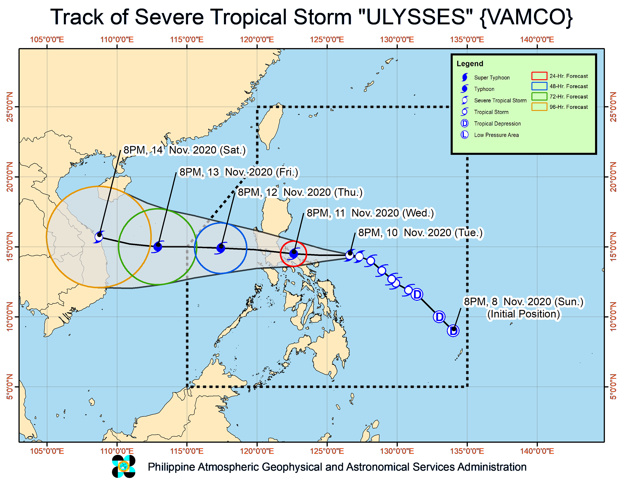
On Wednesday, November 11, Ulysses is expected to pass close to Catanduanes from morning to afternoon, then the northern parts of Camarines Sur and Camarines Norte from afternoon to evening.
“Due to the proximity of the center of the storm over these provinces during the passage, it is highly likely that these areas will be within the inner rainbands or eyewall region,” PAGASA warned.
Ulysses’ center could cross the Calaguas Islands in Camarines Norte on Wednesday afternoon or evening, then make landfall in Polillo Island and mainland Quezon between Wednesday evening and early Thursday morning, November 12.
In the early hours of Thursday, Ulysses will cross mainland Luzon. Afterwards, it may emerge over the western seaboard of Central Luzon on Thursday morning.
PAGASA also said that while Ulysses could weaken as it crosses mainland Luzon, especially with the Sierra Madre mountain range, it is likely to remain a typhoon by then.
In terms of rainfall, below is PAGASA’s outlook for the next 24 hours. Areas to be affected by Ulysses must be on alert for floods, landslides, and lahar flows.
Late Tuesday evening, November 10, until Wednesday morning, November 11
Moderate to heavy rain, with at times intense rain
- Catanduanes
- Camarines Sur
- Albay
- Sorsogon
- Northern Samar
Light to moderate rain, with at times heavy rain
- Aurora
- Quezon including Polillo Island
- Marinduque
- rest of Bicol
- rest of Eastern Visayas
Wednesday morning to late evening, November 11
Heavy to intense rain, with at times torrential rain
- Catanduanes
- Camarines Norte
- Camarines Sur
- Albay
- Quezon including Polillo Island
- Marinduque
Moderate to heavy rain
- rest of Bicol
- rest of Calabarzon
- eastern part of Cagayan
- eastern part of Isabela
- Aurora
- Nueva Ecija
- Bulacan
- Metro Manila
- Northern Samar
Light to moderate rain, with at times heavy rain
- rest of Luzon
- rest of Visayas
PAGASA also warned that there is a high risk of storm surges which “can cause life-threatening and damaging coastal inundation.”
Up to 3 meters high
- coastal areas of Quezon including Polillo Island, Camarines Norte, and Catanduanes
- northern and eastern coastal areas of Camarines Sur
Up to 2 meters high
- coastal areas of Aurora, Bataan, Pampanga, Bulacan, Metro Manila, Cavite, Batangas, northern parts of Oriental Mindoro and Occidental Mindoro including Lubang Island, Marinduque, Romblon, Masbate including Ticao and Burias Islands, Albay, and Sorsogon
- remaining coastal areas of Camarines Sur
“Moreover, there is also a moderate risk of seiche or storm surge over the coastal areas surrounding Laguna de Bay and Taal Lake,” PAGASA said.
Ulysses will also cause rough to very high seas, with waves 2.5 to 10 meters high, in these seaboards:
- seaboards of areas under Signal Nos. 1 and 2
- eastern seaboard of Eastern Samar (parts that are not under a tropical cyclone wind signal)
The surge of the northeast monsoon will also trigger rough to high seas, with waves 3 to 6 meters high, in the remaining seaboards of Northern Luzon, and rough seas, with waves 2.5 to 3.5 meters high, in the seaboards of the Kalayaan Islands.
Meanwhile, waters will be moderate to rough, with waves 1.5 to 2.5 meters high in these seaboards:
- western seaboards of Palawan including Calamian Islands
- eastern seaboards of Mindanao
Ulysses could exit the Philippine Area of Responsibility (PAR) on Friday, November 13.
Ulysses is the Philippines’ 21st tropical cyclone for 2020 – already above the yearly average of 20. (READ: LIST: PAGASA’s names for tropical cyclones in 2020)
For the next 6 months, these are PAGASA’s estimates for tropical cyclones inside PAR:
- November 2020 – 1 to 3
- December 2020 – 2 or 3
- January 2021 – 0 or 1
- February 2021 – 0 or 1
- March 2021 – 0 or 1
- April 2021 – 0 or 1
Since October, La Niña has been underway, which means there is more rain than usual.
Then in November, the northeast monsoon began, signaling “surges of cold temperatures.”
PAGASA warned that La Niña may enhance the northeast monsoon, which could trigger floods and landslides. – Rappler.com
Add a comment
How does this make you feel?


There are no comments yet. Add your comment to start the conversation.