SUMMARY
This is AI generated summarization, which may have errors. For context, always refer to the full article.
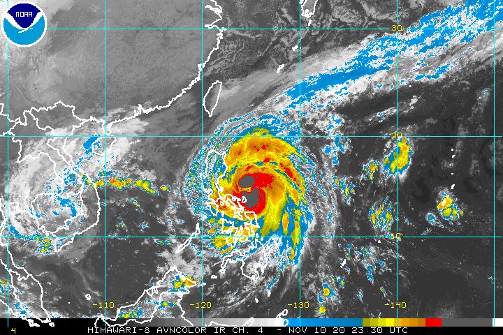
Severe Tropical Storm Ulysses (Vamco) further intensified early Wednesday morning, November 11, and is now nearing typhoon category.
The Philippine Atmospheric, Geophysical, and Astronomical Services Administration (PAGASA) said in a bulletin released past 8 am on Wednesday that Ulysses now has maximum sustained winds of 110 kilometers per hour (km/h) from the previous 100 km/h and gustiness of up to 135 km/h from the previous 125 km/h.
A typhoon is classified as having maximum sustained winds of 118 to 220 km/h.
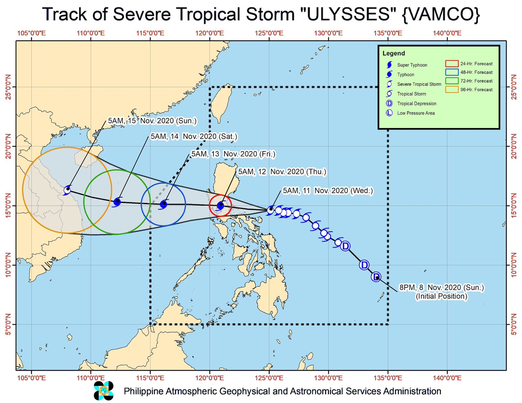
PAGASA said Ulysses may intensify into a typhoon within 6 to 12 hours and reach its peak intensity of 130 to 155 km/h before landfall. (READ: FAST FACTS: Tropical cyclones, rainfall advisories)
As of early Wednesday morning, the severe tropical storm is located 135 kilometers north northeast of Virac, Catanduanes, or 350 kilometers east of Infanta, Quezon.
It slightly accelerated, now moving west at 20 km/h from the previous 15 km/h.
The state weather bureau maintained this rainfall outlook for Ulysses:
Wednesday morning to late afternoon, November 11
Heavy to intense rain, with at times torrential rain
- Camarines Norte
- Camarines Sur
- Catanduanes
Moderate to heavy rain, with at times intense rain
- Albay
- Sorsogon
- Quezon including Polillo Island
- Burias and Ticao Islands
Light to moderate rain, with at times heavy rain
- rest of Luzon
- Visayas
Late Wednesday afternoon, November 11, to early Thursday morning, November 12
Heavy to intense rain, with at times torrential rain
- Camarines Norte
- Camarines Sur
- Metro Manila
- Calabarzon
- Aurora
- Bulacan
- Pampanga
- Bataan
Moderate to heavy rain, with at times intense rain
- Cordillera Administrative Region
- mainland Cagayan Valley
- Catanduanes
- Marinduque
- northern part of Occidental Mindoro
- northern part of Oriental Mindoro
- rest of Central Luzon
Light to moderate rain, with at times heavy rain
- rest of Luzon
- Visayas
Areas to be affected must watch out for possible floods, landslides, and lahar flows.
The list of areas under tropical cyclone wind signals was further expanded as of 8 am on Wednesday.
Signal No. 2
- central and southern parts of Quirino (Maddela, Cabarroguis, Aglipay, Nagtipunan)
- central and southern parts of Nueva Vizcaya (Kasibu, Bambang, Kayapa, Dupax del Norte, Dupax del Sur, Aritao, Santa Fe, Alfonso Castañeda)
- southern part of Benguet (Bokod, Itogon, Tublay, La Trinidad, Sablan, Baguio City, Tuba)
- southern part of La Union (Burgos, Naguilian, Bauang, Caba, Aringay, Tubao, Pugo, Santo Tomas, Rosario, Agoo)
- Pangasinan
- Zambales
- Bataan
- Tarlac
- Pampanga
- Nueva Ecija
- Aurora
- Bulacan
- Metro Manila
- Rizal
- Laguna
- Cavite
- Batangas
- Quezon including Polillo Island
- Marinduque
- northern part of Occidental Mindoro (Paluan, Abra de Ilog) including Lubang Island
- northern part of Oriental Mindoro (Pola, Victoria, Naujan, Baco, Calapan City, San Teodoro, Puerto Galera)
- Camarines Norte
- Camarines Sur
- Albay
- Sorsogon
- Catanduanes
- Burias and Ticao Islands
Signal No. 1
- Isabela
- rest of Quirino
- rest of Nueva Vizcaya
- Kalinga
- Mountain Province
- Ifugao
- rest of Benguet
- Abra
- Ilocos Sur
- rest of La Union
- rest of Occidental Mindoro
- rest of Oriental Mindoro
- Romblon
- rest of Masbate
- Northern Samar
- northern part of Samar (Santo Niño, Almagro, Tagapul-an, Tarangnan, Calbayog City, Santa Margarita, Gandara, Pagsanghan, San Jorge, San Jose de Buan, Matuguinao)
- northern part of Eastern Samar (Maslog, Dolores, Oras, San Policarpo, Arteche, Jipapad)
PAGASA said areas under Signal No. 2 should brace for damaging gale-force to storm-force winds, while those under Signal No. 1 will have strong breeze to near gale conditions during the passage of Ulysses.
But once Ulysses intensifies into a typhoon, Signal No. 3 could be raised over Metro Manila as well as parts of Central Luzon, Calabarzon, and Bicol.
In the rest of Northern Luzon, there will also be strong breeze to gale-force winds due to the surge of the northeast monsoon or hanging amihan.
According to PAGASA, Ulysses will pass over the seas north of Catanduanes between Wednesday morning and afternoon, and then north of Camarines Sur and Camarines Norte between Wednesday afternoon and evening.
“Due to the orientation of the track forecast, these provinces may fall within the inner rainbands or eyewall region of this storm during the passage,” the state weather bureau warned.
Ulysses’ center is forecast to make landfall in Polillo Island and mainland Quezon between Wednesday evening and early Thursday morning, November 12.
Then it would cross mainland Luzon and emerge over the western seaboard of Central Luzon between Thursday morning and afternoon.
PAGASA said Ulysses could slightly weaken as it crosses mainland Luzon “due to frictional effects in the presence of the Sierra Madre and Zambales mountain ranges.” But it is likely to remain a typhoon.
PAGASA also warned that there is a high risk of storm surges which “can cause life-threatening and damaging coastal inundation.”
Up to 3 meters high
- coastal areas of Quezon including Polillo Island, Camarines Norte, and Catanduanes
- northern and eastern coastal areas of Camarines Sur
Up to 2 meters high
- coastal areas of Aurora, Bataan, Pampanga, Bulacan, Metro Manila, Cavite, Batangas, northern parts of Oriental Mindoro and Occidental Mindoro including Lubang Island, Marinduque, Romblon, Masbate including Ticao and Burias Islands, Albay, and Sorsogon
- remaining coastal areas of Camarines Sur
“Moreover, there is also a moderate risk of seiche or storm surge over the coastal areas surrounding Laguna de Bay,” PAGASA said.
Ulysses will also cause rough to very high seas, with waves 2.5 to 10 meters high, in these seaboards:
- seaboards of areas under Signal Nos. 1 and 2
- eastern seaboard of Eastern Samar (parts that are not under a tropical cyclone wind signal)
The surge of the northeast monsoon will also trigger rough to high seas, with waves 3 to 6 meters high, in the remaining seaboards of Northern Luzon, and rough seas, with waves 2.5 to 3.5 meters high, in the seaboards of the Kalayaan Islands.
Meanwhile, waters will be moderate to rough, with waves 1.5 to 2.5 meters high in these seaboards:
- western seaboards of Palawan including Calamian Islands
- eastern seaboards of Mindanao
Ulysses could exit the Philippine Area of Responsibility (PAR) on Friday, November 13.
Ulysses is the Philippines’ 21st tropical cyclone for 2020 – already above the yearly average of 20. (READ: LIST: PAGASA’s names for tropical cyclones in 2020)
For the next 6 months, these are PAGASA’s estimates for tropical cyclones inside PAR:
- November 2020 – 1 to 3
- December 2020 – 2 or 3
- January 2021 – 0 or 1
- February 2021 – 0 or 1
- March 2021 – 0 or 1
- April 2021 – 0 or 1
Since October, La Niña has been underway, which means there is more rain than usual.
Then in November, the northeast monsoon began, signaling “surges of cold temperatures.”
PAGASA warned that La Niña may enhance the northeast monsoon, which could trigger floods and landslides. – Rappler.com
Add a comment
How does this make you feel?


There are no comments yet. Add your comment to start the conversation.