SUMMARY
This is AI generated summarization, which may have errors. For context, always refer to the full article.
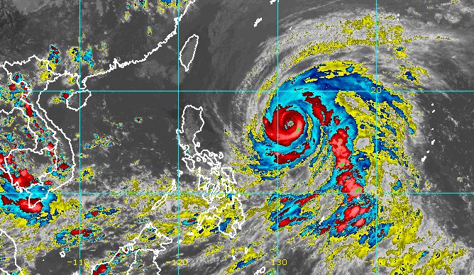
MANILA, Philippines – More areas were placed under Signal No. 1 due to Super Typhoon Betty (Mawar) on Saturday afternoon, May 27, as the tropical cyclone shifted westward.
In its 5 pm bulletin on Saturday, the Philippine Atmospheric, Geophysical, and Astronomical Services Administration (PAGASA) said Betty was located 1,035 kilometers east of Central Luzon.
The super typhoon is now moving west at 25 kilometers per hour, slightly slower than its previous speed of 30 km/h. It was also heading west northwest earlier.
Betty slightly weakened on Saturday afternoon, with its maximum sustained winds decreasing from 195 km/h to 185 km/h. Its gustiness went down from 240 km/h to 230 km/h.
The super typhoon remains less likely to make landfall, but it will still affect Northern Luzon.
The following areas are under Signal No. 1 as of 5 pm on Saturday, which means they will be seeing strong winds:
- Batanes
- Cagayan including Babuyan Islands
- Isabela
- Apayao
- Ilocos Norte
- northern and central parts of Abra (Tineg, Lacub, Lagayan, San Juan, Lagangilang, Licuan-Baay, Malibcong, Danglas, La Paz, Dolores, Tayum, Bucay, Sallapadan, Daguioman, Bucloc, Boliney)
- Kalinga
- eastern and central parts of Mountain Province (Sadanga, Barlig, Natonin, Paracelis, Bontoc)
- eastern and central parts of Ifugao (Mayoyao, Aguinaldo, Alfonso Lista, Banaue, Hingyon, Lagawe, Lamut, Kiangan, Asipulo)
- northern and central parts of Aurora (Dilasag, Casiguran, Dinalungan, Dipaculao)
- Quirino
- northeastern part of Nueva Vizcaya (Kasibu, Quezon, Solano, Bagabag, Diadi, Villaverde, Bayombong, Ambaguio)
PAGASA added that the southwest monsoon or habagat to be enhanced by the super typhoon may bring “strong breeze to near-gale conditions with intermittent gusts” starting Sunday evening, May 28, or early Monday, May 29, to the Visayas, the western parts of Central Luzon and Southern Luzon, and the northern and western parts of Mindanao.
The weather bureau also updated its rainfall forecast for Betty on Saturday afternoon. Rain from the super typhoon is now expected to begin on Monday afternoon.
Monday afternoon, May 29, to Tuesday afternoon, May 30
- 100-200 millimeters (mm): Batanes, Babuyan Islands, and northern parts of mainland Cagayan, Apayao, Ilocos Norte, and Ilocos Sur
- 50-100 mm: La Union, rest of Cordillera Administrative Region
Tuesday afternoon, May 30, to Wednesday afternoon, May 31
- Greater than 200 mm: Batanes
- 100-200 mm: Babuyan Islands, Ilocos Norte, Ilocos Sur, La Union
- 50-100 mm: Cordillera Administrative Region, northern part of mainland Cagayan
Rainfall will be “generally higher in elevated or mountainous areas,” PAGASA said.
The enhanced southwest monsoon, meanwhile, is seen to trigger monsoon rain in the western parts of Mimaropa, the Visayas, and Mindanao on Sunday.
On Monday and Tuesday, May 30, monsoon rain is likely in the western parts of Mimaropa and Western Visayas, and possible in the remaining areas of these two regions.
The rain could cause floods and landslides.
For coastal waters, PAGASA issued a gale warning for the northern and eastern seaboards of Northern Luzon, eastern seaboards of Central Luzon and Southern Luzon, and eastern seaboards of the Visayas and Mindanao. Conditions in these seaboards could be risky for small vessels.

Betty is now expected to move west in the next 12 hours or until Sunday morning, before turning west northwest.
On Monday, it could turn northwest and slow down as it moves over the waters east of extreme Northern Luzon. Then it might become almost stationary between late Tuesday and early Wednesday, May 31, when it will be closest to Batanes or within 250 to 300 kilometers, said PAGASA.
In terms of intensity, Betty may remain a super typhoon during the weekend.
“Although it will likely maintain its strength for the next 36 to 48 hours, short-term intensification is not ruled out especially in the next 12 to 24 hours,” said the weather bureau.
On Monday or Tuesday, however, Betty “may begin weakening considerably” as it lingers over the waters east of Batanes. It is projected to be downgraded to a typhoon then.
Betty entered the Philippine Area of Responsibility at 2 am on Saturday. It is the country’s second tropical cyclone for 2023 and the first super typhoon of the year. – Rappler.com
Add a comment
How does this make you feel?


There are no comments yet. Add your comment to start the conversation.