SUMMARY
This is AI generated summarization, which may have errors. For context, always refer to the full article.
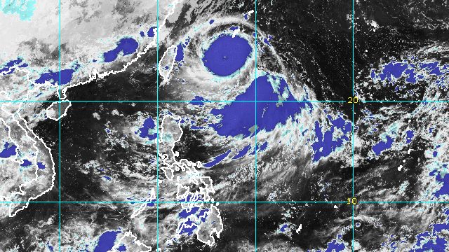
MANILA, Philippines – Batanes and Babuyan Islands may start to feel the effects of Super Typhoon Henry (Hinnamnor) on Thursday, September 1, even though the tropical cyclone is not expected to make landfall.
In its 11 pm bulletin on Wednesday, August 31, the Philippine Atmospheric, Geophysical, and Astronomical Services Administration (PAGASA) said Henry was already 690 kilometers northeast of Itbayat, Batanes, still moving west southwest at 25 kilometers per hour (km/h).
The super typhoon slightly weakened due to “a nearly complete eyewall replacement cycle,” PAGASA said. This occurs “when a second concentric eyewall forms around the original and eventually overtakes it,” according to the World Meteorological Organization.
Henry’s maximum sustained winds decreased from 195 km/h to 185 km/h, while its gustiness is now up to 230 km/h from the previous 240 km/h. Despite the decrease, it remains powerful.
PAGASA provided the following rainfall forecast for the super typhoon:
Late Thursday afternoon to evening, September 1
- light to moderate rain, with at times heavy rain, in Batanes and Babuyan Islands
Friday, September 2
- moderate to heavy rain in Batanes and Babuyan Islands
Early Saturday morning to afternoon, September 3
- moderate to heavy rain in Batanes
- light to moderate rain, with at times heavy rain, in Babuyan Islands
The weather bureau warned that there may be isolated to scattered floods and landslides.
Henry is also seen to enhance the southwest monsoon or hanging habagat, which will affect the western part of Luzon. A separate weather advisory is expected to be issued for the southwest monsoon.
PAGASA added that tropical cyclone wind signals could be raised for extreme Northern Luzon as early as Thursday “in anticipation of potential strong breeze to near gale conditions.” The weather bureau is not ruling out the declaration of Signal No. 2.
Also on Thursday, Henry may cause moderate to rough seas in the northern and eastern seaboards of Northern Luzon. Waves are projected to be 1.2 to 4 meters high, which would be risky for small vessels.
PAGASA added that a gale warning for the northern seaboard of Northern Luzon could be issued starting Friday, September 2, as sea conditions worsen.
From Thursday evening to Friday afternoon, Henry could become almost stationary. Also during this period, it may gradually weaken and eventually be downgraded to a typhoon.
Afterwards, Henry may accelerate starting Friday evening as it heads for Japan’s Ryukyu Islands and the East China Sea.
Its exit from the Philippine Area of Responsibility (PAR) could be on Saturday evening, September 3, or Sunday morning, September 4.

Henry is also interacting with Tropical Depression Gardo inside PAR.
Gardo was located 1,040 kilometers east northeast of extreme Northern Luzon on Wednesday evening, moving north northwest at 20 km/h, twice its previous speed.
The tropical depression maintained its strength, with maximum sustained winds of 55 km/h and gustiness of up to 70 km/h.
But PAGASA said Gardo would weaken into a remnant low within 12 hours, or by Thursday morning, as it gets absorbed by Henry.

Gardo and Henry are the Philippines’ seventh and eighth tropical cyclones for 2022. Gardo formed inside PAR last Tuesday, August 30, while Henry entered PAR late Wednesday afternoon.
PAGASA expects 7 to 11 tropical cyclones to enter or develop inside PAR from September 2022 to February 2023. Per month, these are the weather bureau’s estimates:
- September 2022 – 2 or 3
- October 2022 – 2 to 4
- November 2022 – 2 or 3
- December 2022 – 1 or 2
- January 2023 – 0 or 1
- February 2023 – 0 or 1
– Rappler.com
Add a comment
How does this make you feel?


There are no comments yet. Add your comment to start the conversation.