SUMMARY
This is AI generated summarization, which may have errors. For context, always refer to the full article.
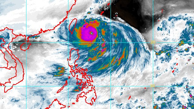
MANILA, Philippines – Super Typhoon Henry (Hinnamnor) strengthened a bit on Thursday morning, September 1, while Tropical Depression Gardo weakened into a low pressure area (LPA) at 8 am.
The Philippine Atmospheric, Geophysical, and Astronomical Services Administration (PAGASA) said in a bulletin issued at 11 am on Thursday that Henry’s maximum sustained winds are back to 195 kilometers per hour from the previous 185 km/h, while its gustiness increased to 240 km/h from 230 km/h.
The super typhoon was last spotted 430 kilometers east northeast of Itbayat, Batanes, moving south southwest at 25 km/h.
While Henry will not make landfall in the Philippines, it will affect extreme Northern Luzon.
Here is PAGASA’s latest rainfall forecast for the super typhoon:
Late Thursday afternoon to evening, September 1
- light to moderate rain, with at times heavy rain, in Batanes
Friday, September 2
- moderate to heavy rain in Batanes and Babuyan Islands
Early Saturday morning to afternoon, September 3
- moderate to heavy rain in Batanes
- light to moderate rain, with at times heavy rain, in Babuyan Islands
Isolated to scattered floods and landslides are possible.
Henry may also enhance the southwest monsoon or hanging habagat, which could trigger rain in the western part of Luzon starting Friday, September 2.
Meanwhile, tropical cyclone wind signals might be raised for extreme Northern Luzon on Thursday “in anticipation of potential strong breeze to near gale conditions.” PAGASA is not ruling out the declaration of Signal No. 2.
The weather bureau also issued a gale warning at 5 am on Thursday, covering the northern and eastern seaboards of Northern Luzon, specifically Batanes, Cagayan, and the northern coast of Ilocos Norte.
In areas under the gale warning, seas are rough to very rough, with waves 2.8 to 5 meters high. PAGASA advised small vessels not to sail and large vessels to watch out for big waves.
Moderate to rough seas may be seen in the eastern seaboard of Isabela on Thursday, too. Waves could be 1.2 to 4 meters high, making conditions risky for small vessels.
By Thursday evening or early Friday morning, Henry is projected to become almost stationary. Then it may start slowly moving northwest on Friday afternoon, before accelerating toward the north on Saturday, September 3.
It could then leave the Philippine Area of Responsibility (PAR) on Saturday evening or Sunday morning, September 4.
PAGASA also expects Henry to further strengthen in the coming hours before it begins weakening during its quasi-stationary phase. But once it speeds up northward on Saturday, it may slightly re-intensify again.

Meanwhile, the LPA or remnant low that used to be Gardo was located 760 kilometers east northeast of Itbayat, Batanes, on Thursday morning.
Gardo had stayed far from Philippine landmass. The remnant low will also have no direct effect on the country.
PAGASA said the remnant low is likely to be fully absorbed by Henry in the next 12 hours, or before Thursday ends.

Gardo was the Philippines’ seventh tropical cyclone for 2022, while Henry is the eighth. Gardo formed inside PAR last Tuesday, August 30, while Henry entered PAR on Wednesday, August 31.
PAGASA expects 7 to 11 tropical cyclones to enter or develop inside PAR from September 2022 to February 2023. Per month, these are the weather bureau’s estimates:
- September 2022 – 2 or 3
- October 2022 – 2 to 4
- November 2022 – 2 or 3
- December 2022 – 1 or 2
- January 2023 – 0 or 1
- February 2023 – 0 or 1
– Rappler.com
Add a comment
How does this make you feel?


There are no comments yet. Add your comment to start the conversation.