SUMMARY
This is AI generated summarization, which may have errors. For context, always refer to the full article.
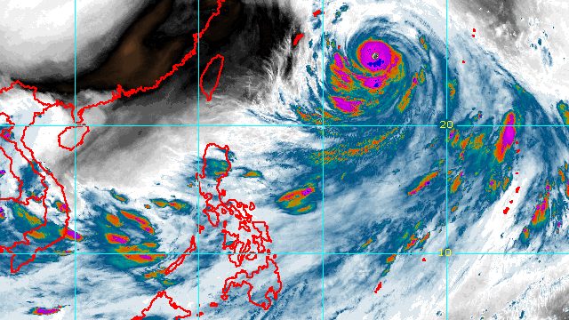
MANILA, Philippines – Josie (Nanmadol) intensified from a typhoon into a super typhoon at 8 pm on Friday, September 16, then left the Philippine Area of Responsibility (PAR) at 10 pm.
It stayed inside PAR for only 4 hours and 20 minutes, having entered at 5:40 pm.
In its first and last bulletin on Josie issued at 11:45 pm, the Philippine Atmospheric, Geophysical, and Astronomical Services Administration (PAGASA) said the super typhoon was already 1,375 kilometers east northeast of extreme Northern Luzon.
Josie is moving northwest at 15 kilometers per hour (km/h), heading for the northern part of Japan’s Ryukyu Islands and the southern part of mainland Japan.
Its maximum sustained winds increased from 175 km/h to 185 km/h, while its gustiness went up to 230 km/h from the previous 215 km/h.
PAGASA noted that Josie underwent “a period of rapid intensification” on Friday, and it is likely to continue strengthening in the near term.
Since Josie stayed far from Philippine landmass, it did not directly affect the country.
But the super typhoon has been enhancing the southwest monsoon or hanging habagat, which will continue to affect Mimaropa and Western Visayas until Saturday, September 17.
Moderate to heavy rain
- Occidental Mindoro
- Palawan
Light to moderate rain, with at times heavy rain
- Oriental Mindoro
- Romblon
- Western Visayas
PAGASA warned that scattered floods and landslides remain likely.
The enhanced southwest monsoon will also cause occasional gusty conditions in these areas on Saturday:
- Mimaropa
- Bicol
- Visayas

Josie was the Philippines’ 10th tropical cyclone for 2022 and the second for September.
It is also the country’s second super typhoon for the year, after Henry (Hinnamnor), which entered PAR on August 31 and left on September 4. Henry did not make landfall too, but it affected the Philippines’ northernmost provinces.
PAGASA expects 7 to 11 tropical cyclones to enter or develop inside PAR from September 2022 to February 2023. Per month, these are the weather bureau’s estimates:
- September 2022 – 2 or 3
- October 2022 – 2 to 4
- November 2022 – 2 or 3
- December 2022 – 1 or 2
- January 2023 – 0 or 1
- February 2023 – 0 or 1
– Rappler.com
Add a comment
How does this make you feel?


There are no comments yet. Add your comment to start the conversation.