SUMMARY
This is AI generated summarization, which may have errors. For context, always refer to the full article.
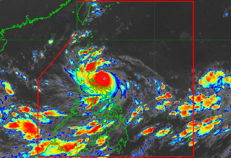
MANILA, Philippines – Karding (Noru) intensified from a typhoon into a super typhoon at 5 am on Sunday, September 25, after what the weather bureau described as a “period of explosive intensification.”
In a bulletin released past 8 am on Sunday, the Philippine Atmospheric, Geophysical, and Astronomical Services Administration (PAGASA) said Karding’s maximum sustained winds had increased by 90 kilometers per hour (km/h) in 24 hours.
As of early Sunday morning, Karding’s maximum sustained winds were already at 185 km/h, prompting the weather bureau to upgrade it to a super typhoon, the strongest type of tropical cyclone. Before dawn, it had maximum sustained winds of 155 km/h.
Karding’s gustiness also increased from 190 km/h to 230 km/h.
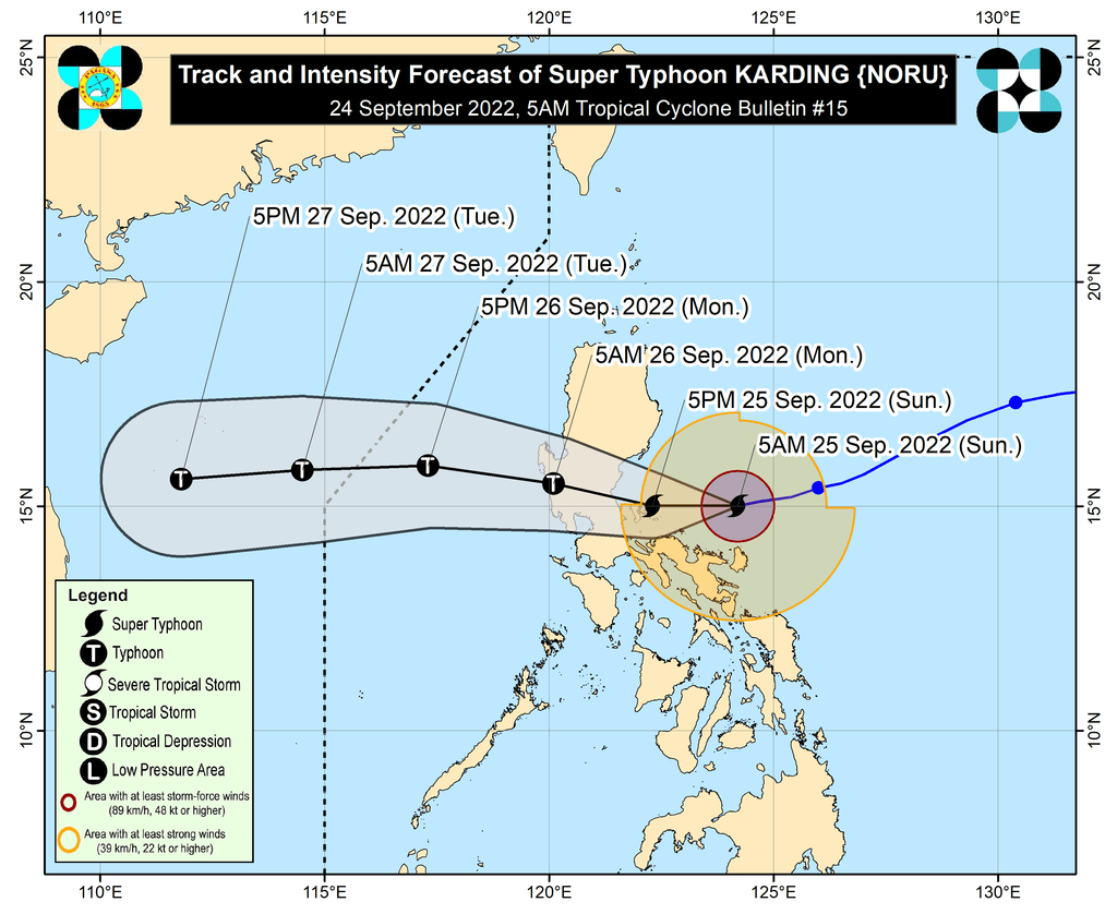
PAGASA warned that Karding may continue to intensify on Sunday. It could make landfall at or near a peak intensity of 185 to 205 km/h.
The super typhoon was located 230 kilometers east of Infanta, Quezon, early Sunday morning, moving west at a slightly slower 20 km/h from the previous 25 km/h.
It is still expected to make landfall in the northern part of Quezon or the southern part of Aurora on Sunday evening. But PAGASA also said it is not ruling out the possibility of the super typhoon making landfall in Quezon’s Polillo Islands in the afternoon.
Polillo Islands was placed under Signal No. 4 as of 8 am on Sunday. Below is the full list of areas under tropical cyclone wind signals.
Signal No. 4
Typhoon-force winds (118 to 184 km/h), significant to severe threat to life and property
- Polillo Islands
Signal No. 3
Storm-force winds (89 to 117 km/h), moderate to significant threat to life and property
- central and southern parts of Aurora (Dingalan, San Luis, Baler, Maria Aurora, Dipaculao)
- central and southern parts of Nueva Ecija (Bongabon, Rizal, Llanera, Science City of Muñoz, Guimba, Cuyapo, Talugtug, Nampicuan, San Antonio, Cabiao, San Isidro, Gapan City, Zaragoza, Jaen, Licab, Quezon, Aliaga, Santa Rosa, San Leonardo, Santo Domingo, Talavera, Cabanatuan City, General Mamerto Natividad, Palayan City, Peñaranda, General Tinio, Laur, Gabaldon)
- Bulacan
- eastern part of Pampanga (Candaba, Arayat, Santa Ana, San Luis, San Simon, Apalit)
- northern part of Metro Manila (Pasig City, Marikina City, Quezon City, San Juan City, Mandaluyong City, City of Manila, Navotas City, Malabon City, Caloocan City, Valenzuela City)
- northern part of Rizal (Rodriguez, Tanay, Baras, Antipolo City, San Mateo, Cainta, Taytay, Angono, Teresa, Morong, Pililla)
- northeastern part of Laguna (Santa Maria, Famy, Siniloan, Pangil, Mabitac, Paete, Kalayaan, Pakil)
- northern part of Quezon (Infanta, Real, General Nakar, Mauban)
- northern part of Camarines Norte (Vinzons, Paracale, Jose Panganiban, Capalonga)
Signal No. 2
Gale-force winds (62 to 88 km/h), minor to moderate threat to life and property
- southern part of Isabela (Dinapigue, San Guillermo, Echague, San Agustin, Jones)
- Quirino
- Nueva Vizcaya
- Benguet
- La Union
- Pangasinan
- Zambales
- Bataan
- Tarlac
- rest of Pampanga
- rest of Nueva Ecija
- rest of Aurora
- rest of Metro Manila
- Cavite
- Batangas
- rest of Laguna
- rest of Rizal
- central part of Quezon (Calauag, Perez, Alabat, Quezon, Tagkawayan, Guinayangan, Sampaloc, Lucban, Tayabas City, Lucena City, Pagbilao, Padre Burgos, Atimonan, Agdangan, Unisan, Plaridel, Gumaca, Lopez, Pitogo, Dolores, Candelaria, Sariaya, Tiaong, San Antonio, Macalelon, General Luna, Catanauan, Buenavista)
- rest of Camarines Norte
- northern part of Camarines Sur (Del Gallego, Ragay, Lupi, Sipocot, Libmanan, Pamplona, Pasacao, San Fernando, Pili, Minalabac, Ocampo, Tigaon, Cabusao, Magarao, Gainza, Canaman, Camaligan, Milaor, Naga City, Bombon, Calabanga, Tinambac, Siruma, Goa, Lagonoy, San Jose, Garchitorena, Presentacion, Caramoan, Sagñay)
- Catanduanes
Signal No. 1
Strong winds (39 to 61 km/h), minimal to minor threat to life and property
- southern part of Cagayan (Tuao, Solana, Enrile, Tuguegarao City, Iguig, Peñablanca)
- rest of Isabela
- southern part of Apayao (Conner)
- Kalinga
- Abra
- Mountain Province
- Ifugao
- southern part of Ilocos Norte (Nueva Era, Badoc, Pinili, Banna, Batac City, Currimao, Paoay, Marcos)
- Ilocos Sur
- rest of Quezon
- northern part of Occidental Mindoro (Abra de Ilog, Paluan, Mamburao, Santa Cruz) including Lubang Islands
- northern part of Oriental Mindoro (Puerto Galera, San Teodoro, Baco, Calapan City, Naujan, Victoria, Pola, Socorro, Pinamalayan)
- Marinduque
- rest of Camarines Sur
- Albay
- Sorsogon
- Burias Island
- Ticao Island
Since Karding is now a super typhoon, Signal No. 5 is the highest possible wind signal.
Aside from fierce winds, Karding is expected to bring torrential rain, which would trigger floods and landslides. Here is PAGASA’s latest rainfall forecast:
Early Sunday morning to early Sunday afternoon, September 25
Moderate to heavy rain
- Isabela
- Polillo Islands
- Catanduanes
- Camarines Norte
- Camarines Sur
Light to moderate rain, with at times heavy rain
- mainland Cagayan
- Quirino
- Nueva Vizcaya
- Aurora
- Quezon
- Marinduque
- Romblon
- rest of Bicol
Early Sunday afternoon, September 25, to early Monday morning, September 26
Heavy to intense rain, with at times torrential rain
- Metro Manila
- Zambales
- Bataan
- Tarlac
- Pampanga
- Nueva Ecija
- Bulacan
- Aurora
- Rizal
- northern part of Quezon including Polillo Islands
Moderate to heavy rain, with at times intense rain
- Isabela
- Nueva Vizcaya
- Quirino
- Benguet
- Ifugao
- Mountain Province
- Pangasinan
- Cavite
- Laguna
- central part of Quezon
- Camarines Norte
Light to moderate rain, with at times heavy rain
- Occidental Mindoro
- Oriental Mindoro
- Marinduque
- rest of Calabarzon
- rest of Bicol
Early Monday morning to early Monday afternoon, September 26
Heavy to intense rain, with at times torrential rain
- Zambales
- Bataan
- Pampanga
- Bulacan
Moderate to heavy rain, with at times intense rain
- Metro Manila
- Pangasinan
- Cavite
- Occidental Mindoro
- rest of Central Luzon
Light to moderate rain, with at times heavy rain
- Mountain Province
- Ifugao
- Benguet
- Quirino
- Nueva Vizcaya
- Oriental Mindoro
- rest of Calabarzon
Karding is also enhancing the southwest monsoon or hanging habagat, which is bringing rain to the Visayas and the rest of Southern Luzon, especially their western sections.
PAGASA also issued the following storm surge warnings:
High to very high risk of storm surges
- northern Quezon including Polillo Islands
- central and southern parts of Aurora
Moderate to high risk of storm surges
- Camarines Norte
- Pangasinan
- Zambales
- Bulacan
- northern part of Metro Manila
- southern part of La Union
- rest of Quezon
- rest of Aurora
The weather bureau warned that the combined effects of storm surges and high waves breaking along the coast may cause “life-threatening and damaging” floods.
As for coastal conditions, a gale warning remains in effect, covering the following seaboards:
- eastern seaboards of Central Luzon and Southern Luzon (Aurora, Quezon including Polillo Islands, Camarines Norte, Camarines Sur, Catanduanes) – very rough to high seas, waves 4.1 to 7 meters high, risky for all vessels
- eastern seaboard of Northern Luzon (Cagayan, Isabela), western seaboards of Central Luzon and Southern Luzon (Zambales, Bataan, Cavite, western coast of Batangas), western seaboards of Northern Luzon and Southern Luzon (Pangasinan, Occidental Mindoro) – rough to very rough seas, waves 2.8 to 4.5 meters high, fishing boats should not sail
Karding and the enhanced southwest monsoon will also cause moderate to rough seas in the northern and western seaboards of Luzon that are not under any gale warning, with waves 1.5 to 3.5 meters high, and in the western seaboard of the Visayas, where waves will be 1.2 to 2.5 meters high. These conditions may be risky for small vessels.
After Karding’s expected landfall on Sunday evening, it will cross Central Luzon, then emerge over the West Philippine Sea via the coastal waters of Zambales or Pangasinan by early Monday morning, September 26.
Karding could exit the Philippine Area of Responsibility (PAR) late Monday.
Karding is the Philippines’ 11th tropical cyclone for 2022.
It is also the third tropical cyclone for September, after Typhoon Inday (Muifa) and Super Typhoon Josie (Nanmadol). Inday and Josie did not make landfall in the country.
PAGASA expects 7 to 11 tropical cyclones to enter or develop inside PAR from September 2022 to February 2023. Per month, these are the weather bureau’s estimates:
- September 2022 – 2 or 3
- October 2022 – 2 to 4
- November 2022 – 2 or 3
- December 2022 – 1 or 2
- January 2023 – 0 or 1
- February 2023 – 0 or 1
– Rappler.com
Add a comment
How does this make you feel?


There are no comments yet. Add your comment to start the conversation.