SUMMARY
This is AI generated summarization, which may have errors. For context, always refer to the full article.

MANILA, Philippines – The tropical cyclone with the international name Mawar re-intensified into a super typhoon as it moved away from the United States island territory of Guam, the Philippines’ weather bureau said before dawn on Thursday, May 25.
Mawar lashed Guam with heavy rain and fierce winds, causing damage, US media outlets reported.
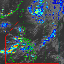
In its 5 am advisory on Thursday, the Philippine Atmospheric, Geophysical, and Astronomical Services Administration (PAGASA) said Super Typhoon Mawar was located 2,130 kilometers east of southeastern Luzon, still outside the Philippine Area of Responsibility (PAR).
It is moving west northwest at 15 kilometers per hour (km/h).
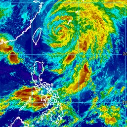
Mawar’s maximum sustained winds are back to 185 km/h, the minimum threshold for the super typhoon category. It was at 175 km/h on Wednesday, May 24, as it had slightly weakened after an eyewall replacement cycle.
The super typhoon’s gustiness also increased to 230 km/h from 215 km/h.
For now, PAGASA sees Mawar moving generally west northwest toward the sea east of extreme Northern Luzon.
The super typhoon is still expected to enter PAR on Friday evening, May 26, or Saturday morning, May 27. It would be given the local name Betty.
While Mawar’s current center track shows it may remain over the sea and spare the Philippines from landfall, PAGASA cautioned that “a much closer approach to the country than the ones shown by the center track” is not being ruled out.
This “closer approach” could happen if Mawar’s track shifts southward or downward, bringing it nearer to Philippine landmass.

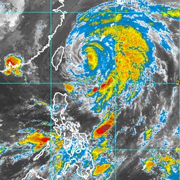
Current forecasts also show that due to Mawar’s massive size, its rainbands are expected to bring heavy rain to the region of Cagayan Valley between Sunday, May 28, and Tuesday, May 30.
The region could also see strong winds from the super typhoon, especially the Batanes-Babuyan Islands area. Tropical cyclone wind signals might be raised in the coming days.
“However, considering potential shifts in the track forecasts of Mawar, residents in Cagayan Valley and other areas of Northern Luzon are advised to monitor for changes in the forecast weather scenario,” added PAGASA.
Mawar is also seen to enhance the impending southwest monsoon or habagat. PAGASA warned of possible monsoon rain in the western parts of Luzon and the Visayas beginning Sunday or Monday, May 29. This forecast may still change, however, depending on Mawar’s track and intensity.
Mawar might strengthen further in the next three days and is now projected to reach a peak intensity of 215 km/h by Sunday. It might weaken after that, but it would still be a strong tropical cyclone, as a typhoon.
Mawar would be the Philippines’ second tropical cyclone for 2023, after Tropical Depression Amang in April. – Rappler.com
Add a comment
How does this make you feel?


There are no comments yet. Add your comment to start the conversation.