SUMMARY
This is AI generated summarization, which may have errors. For context, always refer to the full article.
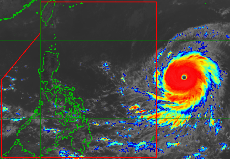
MANILA, Philippines – Super Typhoon Mawar slightly strengthened again on Friday morning, May 26, ahead of its expected entry into the Philippine Area of Responsibility (PAR).
Mawar’s maximum sustained winds increased from 205 kilometers per hour to 215 km/h, said the Philippine Atmospheric, Geophysical, and Astronomical Services Administration (PAGASA) in a press briefing at noontime on Friday.
The super typhoon’s gustiness is already up to 260 km/h from the previous 250 km/h.
It was last spotted 1,705 kilometers east of southeastern Luzon, located over the Philippine Sea and still moving west at 20 km/h.
PAGASA sees Mawar heading generally west northwest until Sunday, May 28, then turning northwest also on Sunday.
The super typhoon is still on track to enter PAR on Friday evening or early Saturday morning, May 27. Once inside PAR, it will be given the local name Betty.
On Sunday, Mawar may slow down as it begins to move closer toward the waters east of extreme Northern Luzon, PAGASA said.
“The center of Mawar’s eye is forecast to be within 250 kilometers of the Batanes-Babuyan archipelago by next week during the slowdown period,” added the weather bureau.
Mawar could stay over water and not make landfall in the Philippines. But PAGASA stressed that the super typhoon can still trigger heavy rain in Northern Luzon starting late Sunday or Monday, May 29. Floods and landslides are possible.
PAGASA Weather Specialist Ana Clauren-Jorda also noted that Mawar has a radius of 500 kilometers, or a wide circulation. This means that even without landfall, tropical cyclone wind signals may be raised in parts of Northern Luzon by Saturday evening to warn affected areas that severe winds are coming in 36 hours.
Jorda said that based on Mawar’s latest forecast track, the highest possible tropical cyclone wind signal would be Signal No. 2 or 3 in Batanes.

Mawar is also seen to enhance the southwest monsoon or habagat. Monsoon rain may hit the western parts of Central Luzon, Southern Luzon, and the Visayas beginning Sunday or Monday, with floods and landslides also possible.
Asked about Metro Manila, PAGASA Deputy Administrator for Research and Development Esperanza Cayanan said the monsoon rain may be strongest on Wednesday, May 31. But she advised the capital region to be on alert even before Wednesday.
“Huwag pa rin nating sabihin na totally wala tayong inaasahan by Monday or Tuesday, kasi may habagat na actually tayo by this time,” Cayanan said.
(Let’s not say that we’re not expecting any rain totally by Monday or Tuesday, because we would already have the southwest monsoon by this time.)
PAGASA also said in its Friday noontime briefing that Mawar may reach its peak intensity within 24 hours.
There may be slight weakening by Saturday evening, but Mawar is expected to remain a super typhoon until Monday morning, according to the weather bureau.
Then by late Monday or Tuesday, May 30, Mawar could weaken “at a slightly faster rate” due to increasing wind shear, cooler sea surface temperatures, and dry air intrusion – conditions which PAGASA described as “unfavorable” for tropical cyclones. It might be downgraded to a typhoon during this period but will remain a strong tropical cyclone.
Mawar would be the Philippines’ second tropical cyclone for 2023, after Tropical Depression Amang in April.
PAGASA earlier said the criteria for declaring the start of the rainy season could be met during or after Mawar’s passage. A declaration on this is expected in the coming days.
In the meantime, the southwesterly windflow will still cause rainshowers and thunderstorms in parts of the Philippines. – Rappler.com
Add a comment
How does this make you feel?


There are no comments yet. Add your comment to start the conversation.