SUMMARY
This is AI generated summarization, which may have errors. For context, always refer to the full article.

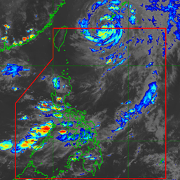
MANILA, Philippines – Super Typhoon Mawar weakened a bit on Friday evening, May 26, but remained a powerful tropical cyclone as it approached the Philippine Area of Responsibility (PAR).
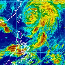
In its 11 pm advisory on Friday, the Philippine Atmospheric, Geophysical, and Astronomical Services Administration (PAGASA) said Mawar’s maximum sustained winds were back to 205 kilometers per hour, just slightly weaker than the previous 215 km/h.
The super typhoon’s gustiness also eased back to 250 km/h from the previous 260 km/h.
As of 10 pm on Friday, Mawar was already 1,475 kilometers east of Central Luzon, moving west northwest at 25 km/h.
PAGASA expects Mawar to enter PAR early Saturday morning, May 27. It will be given the local name Betty.
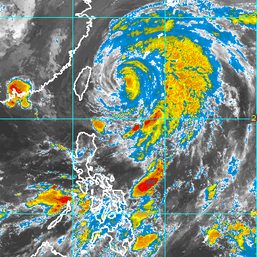
The weather bureau said the super typhoon could maintain its west northwest direction, speeding up until Saturday before gradually slowing down on Sunday, May 28.
By Monday, May 29, it is seen to move slowly northwest while over the waters east of Batanes and could become almost stationary, before shifting north northeast or away from Luzon on Wednesday, May 31.
PAGASA’s updated forecast as of Friday evening shows Mawar may trigger heavy rain in Northern Luzon, especially its northern and western portions, from Monday to Wednesday. Floods and landslides are possible.
Tropical cyclone wind signals could be raised by Saturday for parts of Northern Luzon, to give areas that will be affected 36 hours to prepare for severe winds.

Mawar is also projected to enhance the southwest monsoon or habagat. In its Friday evening advisory, PAGASA said heavy monsoon rain may hit the western parts of Southern Luzon and the Visayas beginning Monday and the western parts of Northern Luzon and Central Luzon starting Wednesday – also the same day the super typhoon could begin moving away from Luzon.
PAGASA sees Mawar maintaining its super typhoon status until the weekend, “although the chance of slight weakening” remains.
On Monday, Mawar could start weakening “at a faster rate” and as a result, be downgraded to a typhoon.
Mawar would be the Philippines’ second tropical cyclone for 2023, after Tropical Depression Amang in April.
PAGASA earlier said the criteria for declaring the start of the rainy season could be met during or after Mawar’s passage. A declaration on this is expected in the coming days.
In the meantime, the southwesterly windflow will still cause rainshowers and thunderstorms in parts of the Philippines. – Rappler.com
Add a comment
How does this make you feel?


There are no comments yet. Add your comment to start the conversation.