SUMMARY
This is AI generated summarization, which may have errors. For context, always refer to the full article.
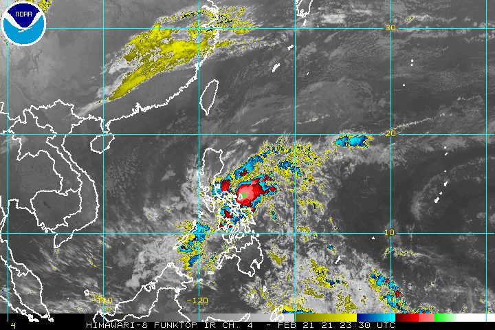
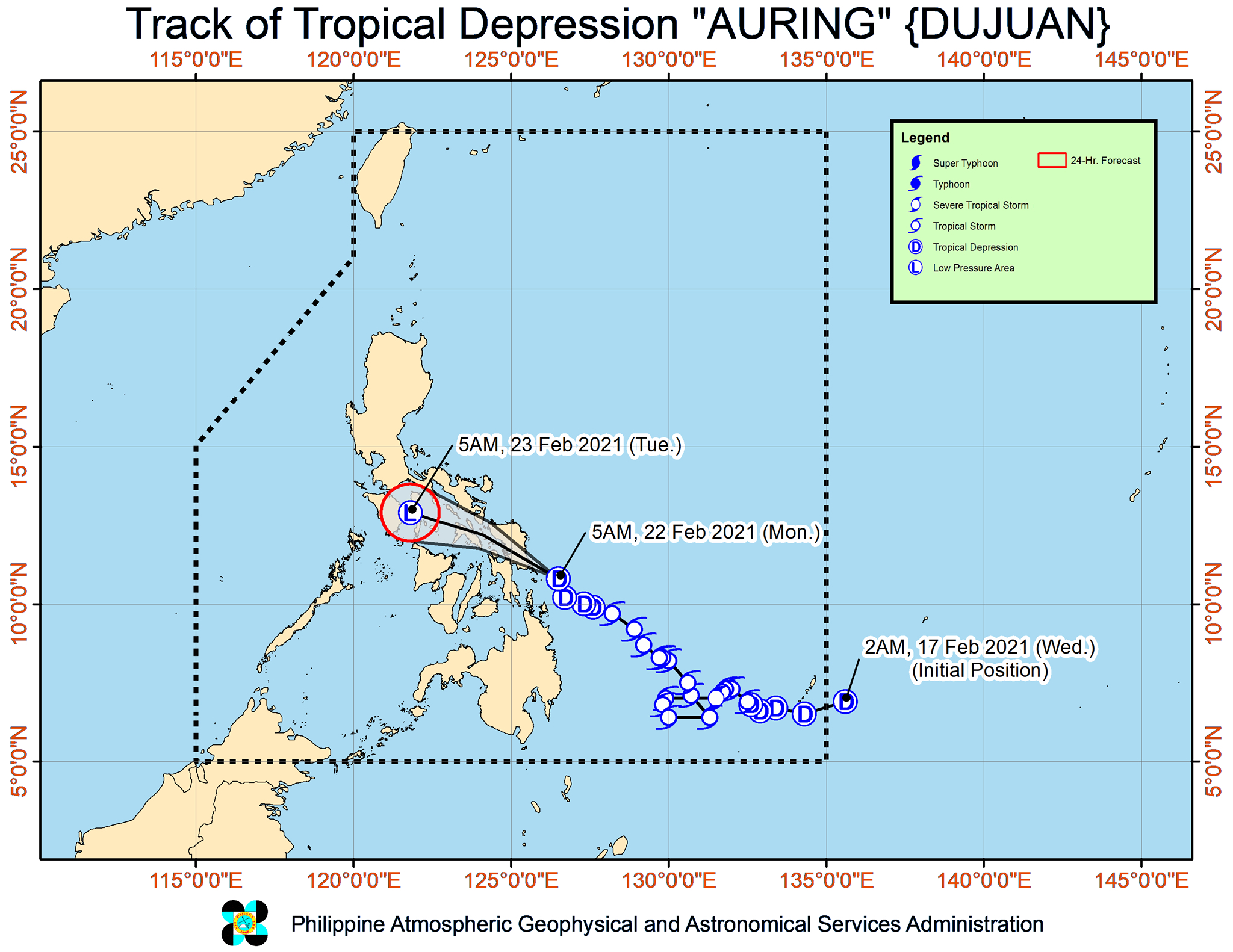
Tropical Depression Auring (Dujuan) shifted and started to head for Eastern Samar early Monday morning, February 22.
In a bulletin issued 8 am on Monday, the Philippine Atmospheric, Geophysical, and Astronomical Services Administration (PAGASA) said Auring is already 205 kilometers east northeast of Maasin City, Southern Leyte, or 85 kilometers east of Guiuan, Eastern Samar.
The tropical depression slightly accelerated, now moving north northwest at 20 kilometers per hour (km/h) from the previous 15 km/h before dawn on Monday.
Its maximum sustained winds are currently at 45 km/h, with gustiness of up to 55 km/h.
PAGASA said Auring could make landfall in Eastern Samar in the next 6 to 12 hours either as a tropical depression or as a remnant low pressure area.
Previously a severe tropical storm and a tropical storm, Auring has been gradually weakening due to interaction with the northeast monsoon or hanging amihan. (READ: FAST FACTS: Tropical cyclones, rainfall advisories)
Below is the state weather bureau’s updated rainfall forecast for Auring. PAGASA warned that “isolated to scattered flooding, including flash floods, and rain-induced landslides” could still occur. (IN PHOTOS: Surigao del Sur flooded due to Tropical Storm Auring)
Monday, February 22
Moderate to heavy rain
- Northern Samar
- Samar
- Eastern Samar
- Biliran
- Leyte
- Bicol
- Marinduque
- Romblon
- Quezon
Light to moderate rain, with at times heavy rain
- rest of Visayas
- rest of Mimaropa
- rest of Calabarzon
- Aurora
Tuesday, February 23
Light to moderate rain, with at times heavy rain
- Calabarzon
- Mimaropa
- Metro Manila
- Camarines Norte
- Bulacan
- Aurora
- Isabela
- Cagayan including Babuyan Islands
- Batanes
PAGASA also said the following areas are experiencing light to moderate rain – possibly heavy at times – due to the northeast monsoon on Monday:
- Metro Manila
- Cagayan Valley
- Cordillera Administrative Region
- Calabarzon
- Mimaropa
- Aurora
Meanwhile, here are the areas under Signal No. 1 as of 8 am on Monday:
- Sorsogon
- Masbate including Ticao and Burias Islands
- Albay
- Catanduanes
- eastern part of Camarines Sur (Caramoan, Presentacion, Sagñay, Buhi, Iriga City, Nabua, Bato, Balatan)
- Northern Samar
- Eastern Samar
- Samar
- Biliran
- Leyte
- Southern Leyte
- northern part of Cebu (Balamban, Cebu City, Mandaue City, Lapu-Lapu City, Consolacion, Liloan, Compostela, Asturias, Danao City, Carmen, Catmon, Sogod, Tuburan, Borbon, San Remigio, Tabuelan, Tabogon, Bogo City, Medellin, Daanbantayan) including Bantayan and Camotes Islands
- northern part of Negros Occidental (Enrique B. Magalona, Victorias City, Manapla, Cadiz City, Sagay City, Toboso, Escalante City, Calatrava)
- eastern part of Capiz (Cuartero, Dumarao, Ma-ayon, Pontevedra, Panay, President Roxas, Panitan, Dao, Pilar)
- eastern part of Iloilo (Lemery, Ajuy, Sara, Concepcion, San Dionisio, Batad, Estancia, Balasan, Carles, San Rafael, Passi City, Barotac Viejo, Banate, San Enrique)
- Dinagat Islands
- Surigao del Norte
PAGASA said Auring and the northeast monsoon combined will bring “strong breeze conditions with occasionally higher gusts” to areas under Signal No. 1.
Similar windy conditions will be experienced in the rest of Bicol and the Visayas, as well as Aurora, Quezon, Marinduque, Romblon, Oriental Mindoro, Batanes, Babuyan Islands, the northern parts of Ilocos Norte and mainland Cagayan, Cuyo Islands, and Cagayancillo Islands.
This is PAGASA’s latest forecast for coastal conditions in the next 24 hours:
Rough seas
Travel is risky, especially for small vessels
- seaboards of areas under Signal No. 1, eastern seaboard of Central Luzon, eastern seaboard of Southern Luzon not under Signal No. 1 (waves 2.5 to 3.5 meters high)
- southern seaboard of Luzon and remaining seaboards of Visayas (waves 2.5 to 3 meters high)
Moderate to rough seas
Small vessels must take precautionary measures, inexperienced mariners should avoid navigation
- remaining seaboards of Luzon and northern, eastern, and western seaboards of Mindanao not under Signal No. 1 (waves 1.2 to 2.5 meters high)
Auring is the Philippines’ first tropical cyclone for 2021.
An average of 20 tropical cyclones form within or enter the Philippine Area of Responsibility (PAR) each year. (READ: LIST: PAGASA’s names for tropical cyclones in 2021)
These are PAGASA’s latest estimates for the number of tropical cyclones inside PAR in the next 6 months:
- February – 0 or 1
- March – 0 or 1
- April – 0 or 1
- May – 0 or 1
- June – 1 or 2
- July – 2 or 3
PAGASA earlier said La Niña is expected to continue until March 2021, causing above normal rainfall in the country. The onset of La Niña was declared in October 2020. – Rappler.com
Add a comment
How does this make you feel?


There are no comments yet. Add your comment to start the conversation.