SUMMARY
This is AI generated summarization, which may have errors. For context, always refer to the full article.
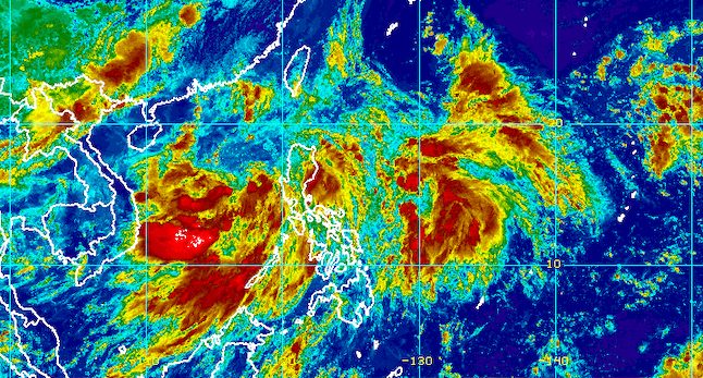
MANILA, Philippines – Tropical Depression Caloy was almost stationary over the West Philippine Sea on Wednesday morning, June 29, as it continued to enhance the southwest monsoon or hanging habagat.
The Philippine Atmospheric, Geophysical, and Astronomical Services Administration (PAGASA) said in a briefing past 11 am that Caloy was located 375 kilometers west of Iba, Zambales, barely moving.
The tropical depression maintained its strength, with maximum sustained winds of 45 kilometers per hour and gustiness of up to 55 km/h.
The southwest monsoon enhanced by Caloy is bringing rain on Wednesday, particularly to the following areas:
Moderate to heavy rain
- Palawan
- Oriental Mindoro
- Occidental Mindoro
- Zambales
- Bataan
- Cavite
- Batangas
- Laguna
Light to moderate rain, with at times heavy rain
- Metro Manila
- rest of Mimaropa
- Rizal
- Tarlac
- Pampanga
- Aurora
- Quezon
- Ilocos Region
- Bicol
- Western Visayas
Areas affected by the enhanced southwest monsoon could have scattered floods and landslides.
There are no tropical cyclone wind signals in place due to Caloy, but occasionally gusty conditions are seen in extreme Northern Luzon as well as the western parts of Luzon and the Visayas due to the enhanced southwest monsoon.
Because of Caloy and the enhanced southwest monsoon, the seaboards of Northern Luzon as well as the western seaboards of Central Luzon and Southern Luzon have moderate to rough seas. Waves are 1.2 to 3.4 meters high, which may be risky for small vessels.

PAGASA said Caloy could remain almost stationary or move west northwest on Wednesday, before turning northwest starting Thursday, June 30, until Friday morning, July 1.
On Saturday, July 2, it may head for the southern part of China, where it is seen to make landfall.
Since it is already near the western boundary of the Philippine Area of Responsibility (PAR), Caloy could make its exit as early as Wednesday evening.
“However, due to the present nature of its circulation, the track and intensity forecast for this tropical depression may still change in the succeeding bulletins,” PAGASA said.
Caloy is expected to remain a tropical depression in the next 48 hours, then strengthen into a tropical storm by Friday afternoon, when it is already outside PAR.
“The large overall circulation and disorganized structure of Caloy suggest a slow pace of intensification in the near term,” PAGASA explained.
Caloy is the Philippines’ third tropical cyclone for 2022. Here are PAGASA’s estimates for tropical cyclones in the next six months:
- July – 2 or 3
- August – 2 or 3
- September – 2 or 3
- October – 2 to 4
- November – 2 or 3
- December – 1 or 2
– Rappler.com
Add a comment
How does this make you feel?


There are no comments yet. Add your comment to start the conversation.