SUMMARY
This is AI generated summarization, which may have errors. For context, always refer to the full article.
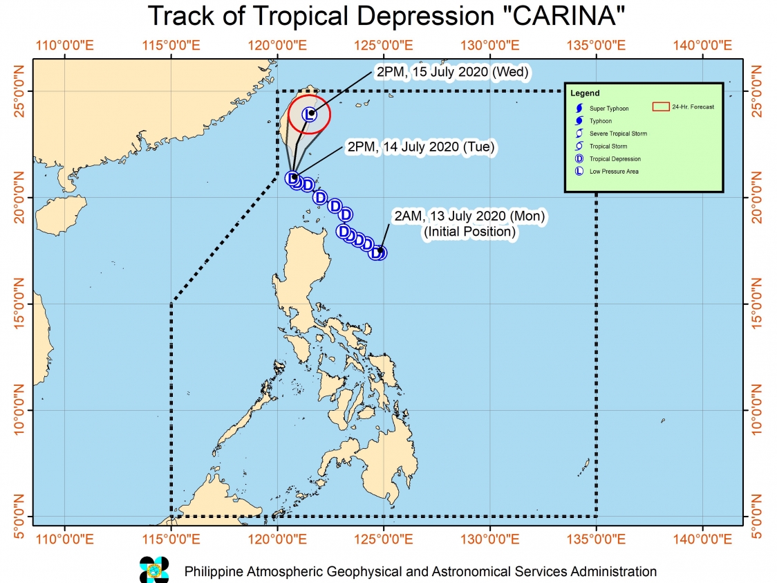
The province of Batanes is no longer under Signal No. 1, with Tropical Depression Carina continuing to move away from the Philippines.
In a bulletin issued 5 pm on Tuesday, July 14, the Philippine Atmospheric, Geophysical, and Astronomical Services Administration (PAGASA) said Carina is now 140 kilometers west northwest of Basco, Batanes.
But the tropical depression slowed down as it moves northwest, said PAGASA.
Carina has maintained its strength, with maximum winds of 45 kilometers per hour (km/h) and gustiness of up to 55 km/h. It is still expected to weaken into a low pressure area on Tuesday or on Wednesday morning, July 15. (READ: FAST FACTS: Tropical cyclones, rainfall advisories)
Though Signal No. 1 has been lifted, PAGASA said coastal areas in extreme Northern Luzon may still have “intermittent gusts.”
Moderate to rough seas will also persist in the seaboards of Batanes, Ilocos Norte, Cagayan including the Babuyan Islands, and Isabela in the next 24 hours. Waves could reach 1.2 to 3.1 meters high, which may be risky for small vessels.
Carina is the Philippines’ 3rd tropical cyclone for 2020, after Typhoon Ambo (Vongfong) in May and Tropical Storm Butchoy (Nuri) in June.
An average of 20 tropical cyclones form within or enter the Philippine Area of Responsibility (PAR) each year. Only around half of these make landfall. (READ: LIST: PAGASA’s names for tropical cyclones in 2020)
In PAGASA’s climate outlook, it gave the following estimates for the number of tropical cyclones inside PAR in the next 6 months:
- July – 2 to 4
- August – 2 or 3
- September – 2 or 3
- October – 2 or 3
- November – 1 or 2
- December – 1 or 2
PAGASA declared the start of the rainy season on June 12. – Rappler.com
Add a comment
How does this make you feel?
There are no comments yet. Add your comment to start the conversation.