SUMMARY
This is AI generated summarization, which may have errors. For context, always refer to the full article.
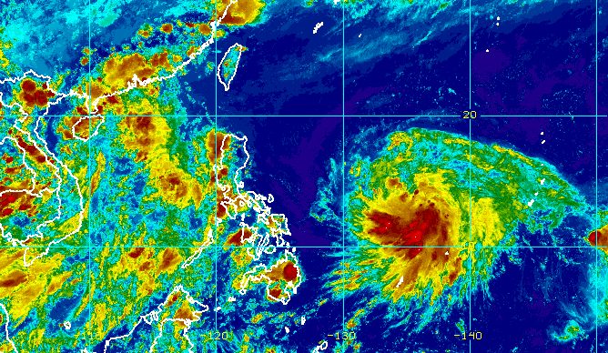
MANILA, Philippines – Tropical Depression Chedeng slightly intensified as it remained almost stationary over the Philippine Sea on Tuesday afternoon, June 6.
Chedeng’s maximum sustained winds increased from 45 kilometers per hour to 55 km/h, said the Philippine Atmospheric, Geophysical, and Astronomical Services Administration (PAGASA) in its 5 pm bulletin on Tuesday.
The tropical depression’s gustiness is now up to 70 km/h from the previous 55 km/h.
Chedeng’s location hardly changed since it is barely moving, with its center 1,150 kilometers east of southeastern Luzon on Tuesday afternoon. It is too far to affect the country.
Chedeng is expected to stay far from Philippine landmass, so it is “unlikely to directly bring heavy rainfall” to any part of the country in the next three to five days.
Tropical cyclone wind signals are also unlikely to be raised.
For the country’s coastal waters, Chedeng won’t be causing rough seas in the next 24 hours.
But the tropical cyclone could enhance the southwest monsoon or habagat in the coming days, according to PAGASA.
The timing and intensity of monsoon rain, as well as the likelihood of gusts or sudden and strong winds, will depend on how Chedeng would enhance the southwest monsoon. The tropical cyclone’s movement and intensity are the key factors to be considered.
PAGASA said it would issue a weather advisory “should there be an increasing chance” of heavy monsoon rain in the next three days.
In the meantime, the southwest monsoon will continue to affect the western part of Southern Luzon on Tuesday. Palawan will experience scattered rain showers and thunderstorms, while the rest of the country will have isolated rain showers or thunderstorms.

PAGASA expects Chedeng to gradually speed up and move generally northwest until Wednesday, June 7, before turning west northwest on Thursday, June 8.
Then it could turn toward the northwest on Friday, June 9, and to the north during the weekend, according to the weather bureau.
While remaining over the Philippine Sea, Chedeng is projected to intensify in the next four days.
PAGASA said on Tuesday afternoon that Chedeng could intensify into a tropical storm within 12 hours, then strengthen into a severe tropical storm on Wednesday and into a typhoon on Thursday.
It may reach its peak intensity on Friday or during the weekend while east of Northern Luzon.
Chedeng is the country’s third tropical cyclone for 2023 and the first for June. PAGASA earlier estimated there would be one or two tropical cyclones during the month.
The weather bureau announced the start of the rainy season last Friday, June 2. – Rappler.com
Add a comment
How does this make you feel?


There are no comments yet. Add your comment to start the conversation.