SUMMARY
This is AI generated summarization, which may have errors. For context, always refer to the full article.
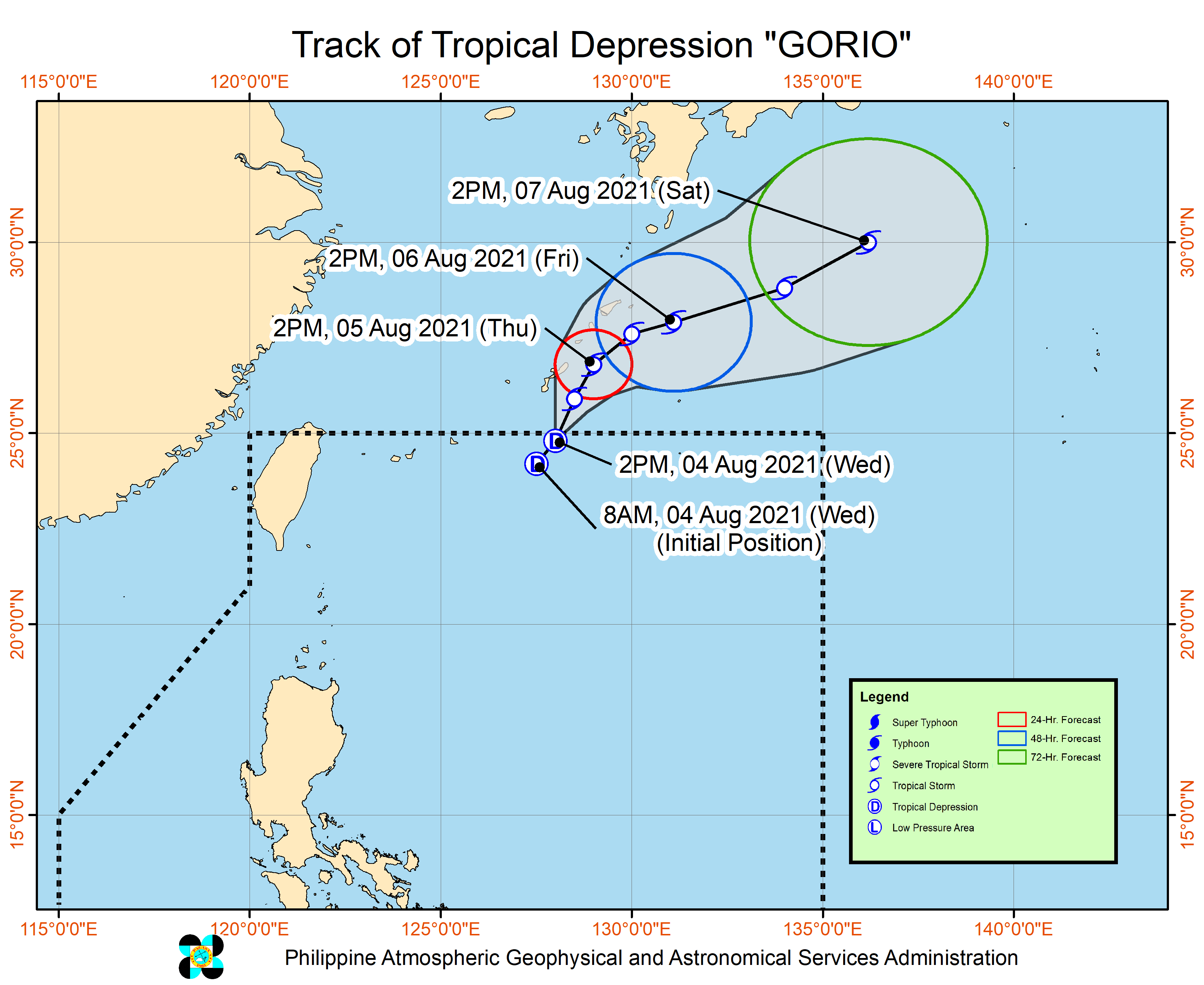
Tropical Depression Gorio stayed inside the Philippine Area of Responsibility (PAR) for only eight hours, as it left at 4 pm on Wednesday, August 4.
Gorio had developed near the PAR’s northern boundary at 8 am on Wednesday. (READ: FAST FACTS: Tropical cyclones, rainfall advisories)
The Philippine Atmospheric, Geophysical, and Astronomical Services Administration (PAGASA) said in its 5 pm bulletin that Gorio was already 800 kilometers northeast of extreme Northern Luzon.
The tropical depression slowed down a bit, moving northeast toward the southern part of Japan at 15 kilometers per hour from the previous 20 km/h.
Gorio also slightly intensified, with maximum sustained winds of 55 km/h and gustiness of up to 70 km/h. It earlier had maximum sustained winds of 45 km/h and gustiness of up to 55 km/h.
PAGASA expects Gorio to strengthen into a tropical storm within 12 hours.
Gorio did not bring rain to the Philippines and tropical cyclone wind signals were not raised.
While Gorio has left PAR, the southwest monsoon or hanging habagat will continue to trigger rain, mainly in Luzon.
Below is PAGASA’s rainfall forecast as of 4 pm on Wednesday, covering the next 24 hours.
Monsoon rain
- Ilocos Region
- Cordillera Administrative Region
- Batanes
- Babuyan Islands
- Zambales
- Bataan
Scattered rain showers and thunderstorms
- rest of Cagayan Valley
- Metro Manila
- Central Luzon
- Cavite
- Batangas
- Rizal
- Occidental Mindoro
Isolated rain showers or thunderstorms
- rest of the Philippines
PAGASA added that occasionally gusty conditions will be experienced in Northern Luzon and Western Luzon, especially in coastal and upland areas.
Rough to very rough seas are also expected in the seaboards of Northern Luzon and Western Luzon, while the remaining seaboards of the country will have moderate to rough waters.
Gorio was the Philippines’ seventh tropical cyclone for 2021 and the first for August.
PAGASA is also monitoring a tropical storm outside PAR, with the international name Lupit.
Tropical Storm Lupit was 655 kilometers west of extreme Northern Luzon on Wednesday afternoon, moving northeast at 10 km/h.
It has maximum sustained winds of 65 km/h and gustiness of up to 80 km/h.
PAGASA Weather Specialist Joey Figuracion said Lupit only has a slim chance of entering PAR.
An average of 20 tropical cyclones form within or enter PAR each year. (READ: LIST: PAGASA’s names for tropical cyclones in 2021)
These are PAGASA’s latest available estimates per month:
2021
- August – 2 or 3
- September – 2 or 3
- October – 2 or 3
- November – 2 or 3
- December – 1 or 2
2022
- January – 0 or 1
The rainy season has been underway since early June. – Rappler.com
Add a comment
How does this make you feel?


There are no comments yet. Add your comment to start the conversation.