SUMMARY
This is AI generated summarization, which may have errors. For context, always refer to the full article.
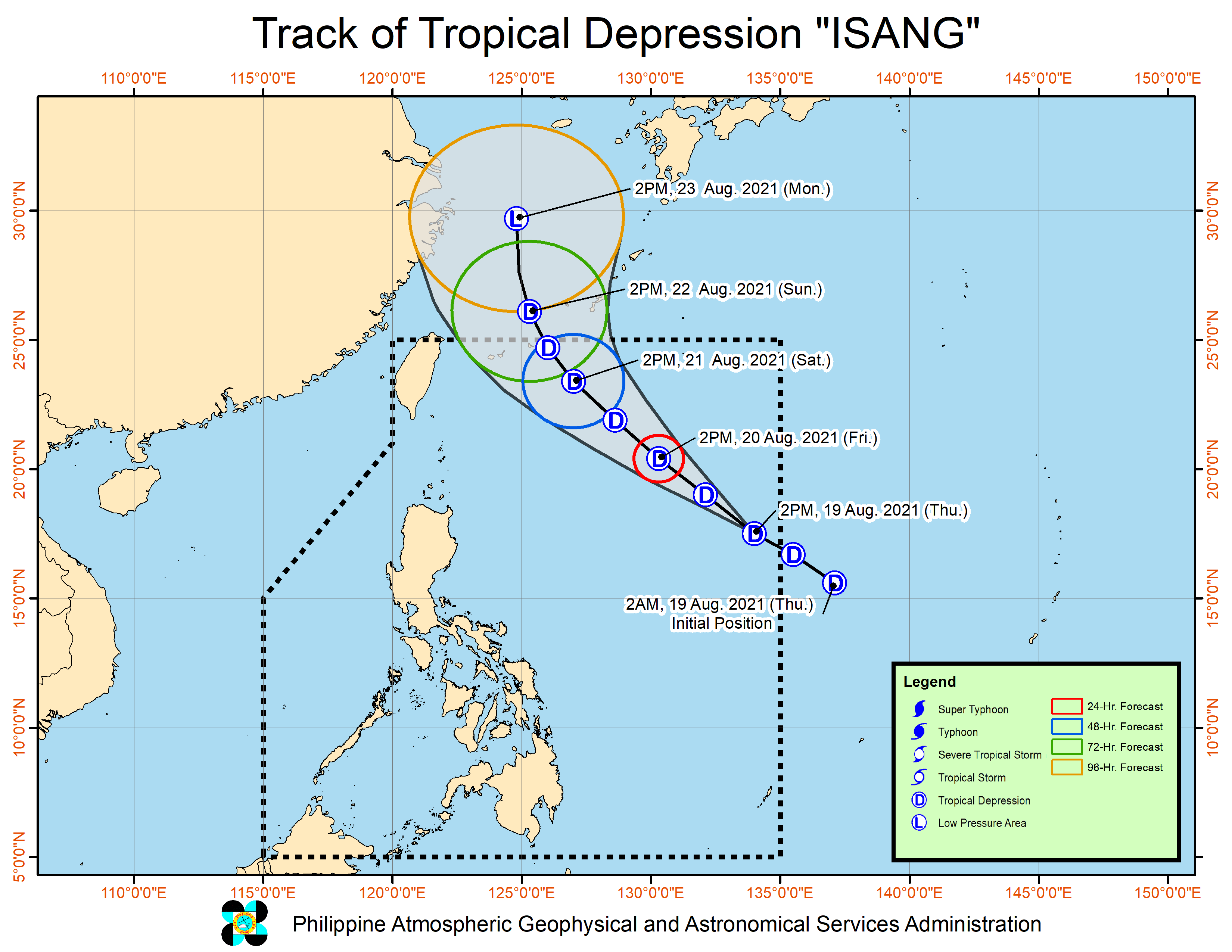
Tropical Depression Isang accelerated over the Philippine Sea on Thursday afternoon, August 19, while the easterlies continued to affect the country.
Isang was last spotted 1,280 kilometers east of Northern Luzon, moving west northwest at 30 kilometers per hour from the previous 25 km/h.
The Philippine Atmospheric, Geophysical, and Astronomical Services Administration (PAGASA) said in a briefing that the tropical depression is expected to remain far from the country.
It is forecast to head northwest until Saturday afternoon, August 21; north northwest by Sunday, August 22; and north by Monday, August 23.
Isang maintained its strength on Thursday afternoon, with maximum sustained winds of 45 km/h and gustiness of up to 55 km/h.
It is likely to stay a tropical depression in the next three days before eventually weakening into a low pressure area by Monday.
With Isang remaining far from land, it will not trigger rain, strong winds, or rough coastal waters.
PAGASA Senior Weather Specialist Chris Perez also said the tropical depression is not seen to enhance the southwest monsoon or hanging habagat.
Isang is expected to leave the Philippine Area of Responsibility (PAR) on Sunday. (READ: FAST FACTS: Tropical cyclones, rainfall advisories)
Isang is the Philippines’ ninth tropical cyclone for 2021 and the third for August.
While Isang is not affecting the country, the easterlies or warm winds coming from the Pacific Ocean will continue to cause hot and humid weather.
There may also be isolated rain or thunderstorms due to the easterlies. Flash floods and landslides are possible during severe thunderstorms.
An average of 20 tropical cyclones form within or enter PAR each year. (READ: LIST: PAGASA’s names for tropical cyclones in 2021)
These are PAGASA’s latest available estimates per month:
2021
- August – 2 or 3
- September – 2 or 3
- October – 2 or 3
- November – 2 or 3
- December – 1 or 2
2022
- January – 0 or 1
The rainy season has been underway since early June. – Rappler.com
Add a comment
How does this make you feel?


There are no comments yet. Add your comment to start the conversation.