SUMMARY
This is AI generated summarization, which may have errors. For context, always refer to the full article.
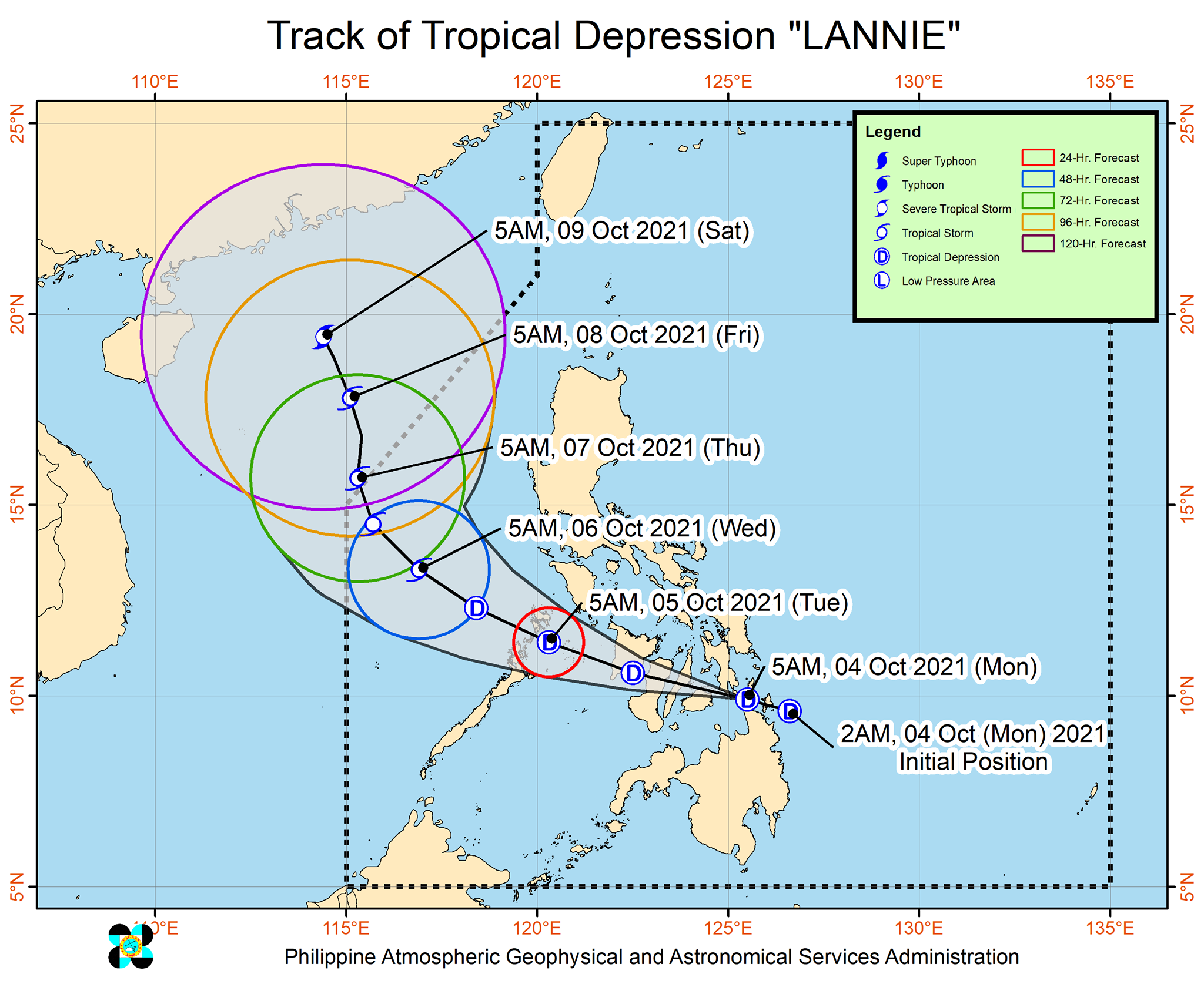
Tropical Depression Lannie made its first two landfalls in the provinces of Surigao del Norte and Dinagat Islands early Monday, October 4.
In a bulletin past 8 am on Monday, the Philippine Atmospheric, Geophysical, and Astronomical Services Administration (PAGASA) said Lannie hit these areas:
- Bucas Grande Island, Socorro, Surigao del Norte – 4:30 am
- Cagdianao, Dinagat Islands – 5 am
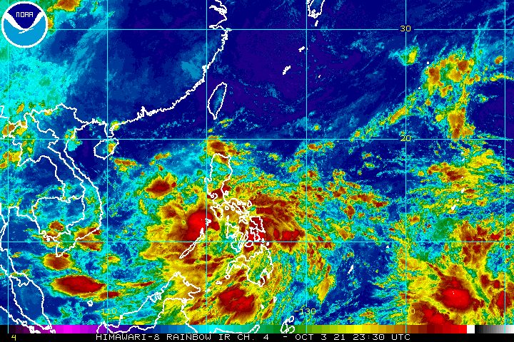
As of 7 am, Lannie was already over the coastal waters of Liloan, Southern Leyte, about to make its third landfall in that province.
The tropical depression slightly slowed down, moving west northwest at 15 kilometers per hour from the previous 20 km/h.
It maintained its strength, with maximum sustained winds of 45 km/h and gustiness of up to 55 km/h. (READ: FAST FACTS: Tropical cyclones, rainfall advisories)
Lannie will continue to bring rain to much of the Philippines throughout Monday until Tuesday morning, October 5. Floods and landslides are possible.
Moderate to heavy rain, with at times intense rain
- Visayas
- Bicol
- Mimaropa
- Calabarzon
- Caraga
Light to moderate rain, with at times heavy rain
- Metro Manila
- Bulacan
- Bataan
- rest of Mindanao
In terms of wind, Signal No. 1 remains raised in these areas:
- southern part of Masbate (Pio V. Corpuz, Cataingan, Palanas, Dimasalang, Uson, Mobo, Milagros, Mandaon, Esperanza, Placer, Cawayan, Balud)
- southern part of Romblon (Cajidiocan, San Fernando, Magdiwang, Santa Maria, Odiongan, Alcantara, Ferrol, Looc, Santa Fe, San Jose)
- southern part of Oriental Mindoro (Roxas, Mansalay, Bulalacao, Bongabong)
- southern part of Occidental Mindoro (Sablayan, Calintaan, Rizal, San Jose, Magsaysay)
- northern part of Palawan (El Nido, Taytay, Dumaran, Araceli), including Calamian and Cuyo Islands
- Eastern Samar
- Samar
- Biliran
- Leyte
- Southern Leyte
- Capiz
- Aklan
- Antique
- Iloilo
- Guimaras
- Negros Occidental
- northern and central parts of Negros Oriental (Bais City, Mabinay, Bayawan City, Basay, Tanjay City, Manjuyod, Bindoy, Ayungon, Tayasan, Jimalalud, La Libertad, Guihulngan City, Vallehermoso, Canlaon City)
- Cebu
- Bohol
- Surigao del Norte
- Dinagat Islands
- northern part of Agusan del Norte (Magallanes, Remedios T. Romualdez, Cabadbaran City, Tubay, Santiago, Jabonga, Kitcharao, Butuan City)
- northern part of Agusan del Sur (Sibagat, Bayugan City, Prosperidad)
- northern part of Surigao del Sur (San Miguel, Marihatag, San Agustin, Cagwait, Bayabas, Tago, Tandag City, Cortes, Lanuza, Carmen, Madrid, Cantilan, Carrascal, Lianga)
Strong winds with occasional gusts are expected in areas under Signal No. 1. (READ: Why is it now called tropical cyclone ‘wind’ – and not ‘warning’ – signals?)
PAGASA added that “the enhanced easterly flow north of the tropical depression may also bring occasional gusts” to extreme Northern Luzon and the coastal and mountainous areas of the eastern part of Luzon on Monday.
Lannie is also causing moderate to rough seas in the Philippines’ coastal waters on Monday, especially in areas under Signal No. 1. Travel is risky for small vessels.
PAGASA expects Lannie to move over the Visayas until Monday evening or early Tuesday morning, then emerge over the Sulu Sea and cross the Cuyo archipelago.
The tropical depression could make another landfall in the northern part of Palawan or Calamian Islands on Tuesday morning before exiting landmass toward the West Philippine Sea within a couple of hours.
From late Tuesday to early Thursday, October 7, Lannie will be moving over the West Philippine Sea.
The weather bureau also said Lannie is likely to stay a tropical depression while crossing land, though it may slightly intensify once over the Sulu Sea or the West Philippine Sea. It could strengthen into a tropical storm by early Wednesday morning, October 6, over the West Philippine Sea.
Lannie may leave the Philippine Area of Responsibility (PAR) on Thursday morning.
Outside PAR, it is seen to head for the southern part of China, and may be upgraded into a severe tropical storm by Saturday morning, October 9.
Lannie is the Philippines’ 12th tropical cyclone for 2021. It is also the first tropical cyclone for the month of October, coming right in the middle of the filing of certificates of candidacy for the 2022 elections, which is taking place across the country. The filing of COCs is until Friday, October 8.
An average of 20 tropical cyclones form within or enter PAR each year. (READ: LIST: PAGASA’s names for tropical cyclones in 2021)
These are PAGASA’s latest estimates for the next six months:
2021
- October – 2 or 3
- November – 2 or 3
- December – 1 or 2
2022
- January – 0 or 1
- February – 0 or 1
- March – 0 or 1
The weather bureau is also monitoring the possible emergence of La Niña in the fourth quarter of 2021. – Rappler.com
Add a comment
How does this make you feel?


There are no comments yet. Add your comment to start the conversation.