SUMMARY
This is AI generated summarization, which may have errors. For context, always refer to the full article.
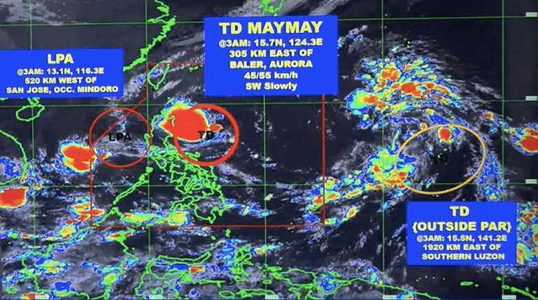
MANILA, Philippines – Tropical Depression Maymay is now seen to weaken into a low pressure area (LPA) before it reaches land, the weather bureau said early Wednesday, October 12.
A new LPA also formed inside the Philippine Area of Responsibility, while another tropical depression located outside PAR continues to be monitored.
In a briefing at 5 am on Wednesday, the Philippine Atmospheric, Geophysical, and Astronomical Services Administration (PAGASA) said Maymay was last spotted 305 kilometers east of Baler, Aurora.
The tropical depression is still moving slowly, heading southwest.
It still has maximum sustained winds of 45 kilometers per hour and gustiness of up to 55 km/h.
PAGASA said Maymay is expected to keep moving slowly or remain almost stationary in the next 12 hours, or for much of Wednesday, before slightly speeding up and heading for the eastern coast of Central Luzon.
While approaching land, Maymay is projected to weaken into an LPA on Thursday, October 13.
But on Wednesday, Maymay and the shear line are still causing rain in Northern Luzon and Central Luzon. Here is PAGASA’s rainfall forecast for the day:
Moderate to heavy rain, with at times intense rain
Maymay
- Isabela
- Aurora
- Quirino
Shear line
- Batanes
- Cagayan
- Apayao
- Kalinga
- Ilocos Norte
Moderate to heavy rain
Maymay, shear line
- rest of Cordillera Administrative Region
- rest of Cagayan Valley
- rest of Ilocos Region
Areas affected by rain must stay on alert for floods and landslides.
In terms of winds, Signal No. 1 is still in effect for the following areas as of 5 am on Wednesday:
- Isabela
- Quirino
- Nueva Vizcaya
- Aurora
- Nueva Ecija
- extreme northern part of Quezon (General Nakar, Infanta) including Polillo Islands
Strong winds will hit areas under Signal No. 1.
PAGASA also said occasional gusts “associated with the enhanced northeasterly surface windflow and its convergence” with Maymay’s circulation may be experienced in these areas:
- Batanes
- Cagayan including Babuyan Islands
- Cordillera Administrative Region
- Ilocos Region

The weather bureau issued a new gale warning at 5 am on Wednesday due to Maymay and the surge of the northeasterly surface windflow. These seaboards have rough to very rough seas:
- northern and western seaboards of Northern Luzon as well as western seaboard of Central Luzon (Batanes, Ilocos Norte, Ilocos Sur, La Union, Pangasinan, Zambales, northern coast of Cagayan) – waves 3.4 to 5.5 meters high
- eastern seaboards of Northern Luzon, Central Luzon, Southern Luzon (Isabela, Aurora, eastern coast of Cagayan, eastern coast of Polillo Island) – waves 2.8 to 4.5 meters high
PAGASA advised fishing boats and other small vessels not to sail, and larger vessels to watch out for big waves.
The weather bureau added that the surge of the northeasterly surface windflow may cause moderate to rough seas in the western seaboards of Central Luzon and Southern Luzon. Waves could be 1.5 to 3.5 meters high, making conditions risky for small vessels.

Meanwhile, the new LPA was located 520 kilometers west of San Jose, Occidental Mindoro, before dawn on Wednesday.
PAGASA Weather Specialist Obet Badrina said the LPA might develop into a tropical depression, but it would be on its way out of PAR.
Aside from Maymay and the new LPA, the tropical depression outside PAR is still under monitoring.
It was last spotted 1,920 kilometers east of Southern Luzon, slowly moving northeast. Badrina said it may enter PAR on Thursday evening or Friday morning, October 14.
The tropical depression maintained its strength early Wednesday, with maximum sustained winds of 45 km/h and gustiness of up to 55 km/h. But on Thursday, it could intensify into a tropical storm.
It is expected to move toward extreme Northern Luzon.
After Maymay, the next two tropical cyclone names on PAGASA’s list are Neneng and Obet. Maymay is the Philippines’ 13th tropical cyclone for 2022 and the first for October.
PAGASA expects 5 to 9 tropical cyclones to enter or develop inside PAR from October 2022 to March 2023. Per month, these are the weather bureau’s estimates:
- October 2022 – 2 to 4
- November 2022 – 2 or 3
- December 2022 – 1 or 2
- January 2023 – 0 or 1
- February 2023 – 0 or 1
- March 2023 – 0 or 1
– Rappler.com
Add a comment
How does this make you feel?


There are no comments yet. Add your comment to start the conversation.