SUMMARY
This is AI generated summarization, which may have errors. For context, always refer to the full article.
MANILA, Philippines – The tropical depression east of extreme Northern Luzon entered the Philippine Area of Responsibility (PAR) at 12 pm on Thursday, October 13.
It was given the local name Neneng, as the Philippines’ 14th tropical cyclone for 2022. It is also the second tropical cyclone for October.
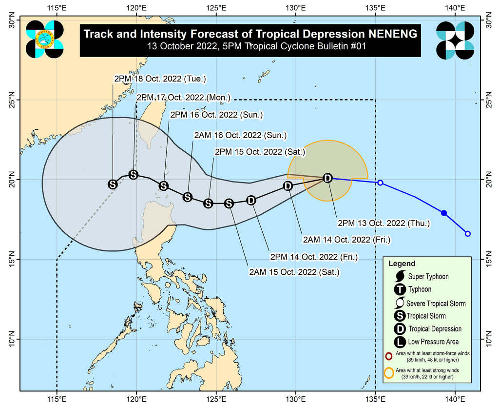
The Philippine Atmospheric, Geophysical, and Astronomical Services Administration (PAGASA) said in a briefing past 5 pm on Thursday that Neneng was located 1,030 kilometers east of extreme Northern Luzon, moving west at 30 kilometers per hour (km/h).
The tropical depression has maximum sustained winds of 55 km/h and gustiness of up to 70 km/h.
PAGASA said Neneng is expected to move west southwest until Friday, October 14, then turn west on Saturday, October 15, while slowing down.
Also on Saturday, Neneng may strengthen into a tropical storm. In addition, PAGASA is not ruling out the possibility that it may intensify further over the Philippine Sea.
On Sunday, October 16, Neneng will be heading west northwest toward extreme Northern Luzon. It could make landfall in or pass very close to Babuyan Islands or Batanes that day.
Even before its possible landfall, however, Neneng could already bring heavy rain to Northern Luzon starting Saturday. There may be isolated to scattered floods and landslides.
Signal No. 1 could be raised for the eastern part of Northern Luzon as early as Friday morning or afternoon, to give the public 36 hours to prepare for strong winds.
Since Neneng is seen to become a tropical storm, Signal No. 2 is the highest possible wind signal.
PAGASA also issued a gale warning at 5 pm on Thursday due to the northeasterly surface windflow.
- seaboards of Northern Luzon (Batanes, Cagayan, Isabela, Ilocos Norte, Ilocos Sur, La Union, Pangasinan) – rough to very rough seas, with waves 3.1 to 5 meters high
- western seaboard of Central Luzon (Zambales) – rough seas, with waves 2.8 to 4 meters high
PAGASA advised fishing boats and other small vessels not to sail, and larger vessels to watch out for big waves.
The weather bureau added that the surge of the northeasterly surface windflow and Neneng may cause moderate to rough seas in the eastern seaboards of Central Luzon and Southern Luzon. Waves could be 1.5 to 3.5 meters high, making conditions risky for small vessels.
Before Neneng, there was Tropical Depression Maymay, which weakened into a low pressure area (LPA) at 2 am on Thursday. It then dissipated at 3 pm.
Another LPA that was being monitored by PAGASA, located over the West Philippine Sea, left PAR at 6 am. It has since developed into a tropical depression, last spotted 210 kilometers north northwest of Pag-asa Island, Palawan, on Thursday afternoon. It will continue to move away from the country.
PAGASA expects 5 to 9 tropical cyclones to enter or develop inside PAR from October 2022 to March 2023. Per month, these are the weather bureau’s estimates:
- October 2022 – 2 to 4
- November 2022 – 2 or 3
- December 2022 – 1 or 2
- January 2023 – 0 or 1
- February 2023 – 0 or 1
- March 2023 – 0 or 1
– Rappler.com
Add a comment
How does this make you feel?


There are no comments yet. Add your comment to start the conversation.