SUMMARY
This is AI generated summarization, which may have errors. For context, always refer to the full article.
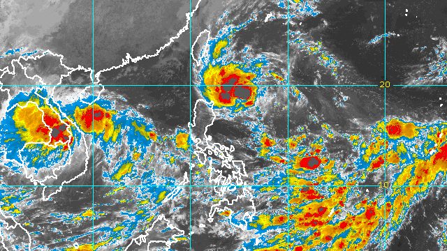
MANILA, Philippines – Tropical Depression Neneng is expected to strengthen into a tropical storm on Saturday, October 15, and eventually into a severe tropical storm while crossing the Batanes-Babuyan Islands area on Sunday, October 16.
Neneng maintained its strength before dawn on Saturday, with maximum sustained winds of 55 kilometers per hour and gustiness of up to 70 km/h.
The Philippine Atmospheric, Geophysical, and Astronomical Services Administration (PAGASA) said in a briefing past 5 am that Neneng was already 575 kilometers east of Calayan, Cagayan, still moving west southwest over the Philippine Sea at 15 km/h.
Neneng could make landfall in or pass very close to Babuyan Islands or Batanes on Sunday morning or afternoon.
PAGASA reminded the public that Northern Luzon will have a rainy weekend. Floods and landslides may occur.
Until Saturday evening, October 15
Light to moderate rain, with at times heavy rain
- Batanes
- Cagayan including Babuyan Islands
- Apayao
- Kalinga
- Abra
- Ilocos Norte
Saturday evening, October 15, to Sunday evening, October 16
Moderate to heavy rain, with at times intense rain
- Batanes
- Cagayan including Babuyan Islands
- Apayao
- Kalinga
- Abra
- Ilocos Norte
- Ilocos Sur
Light to moderate rain, with at times heavy rain
- northern part of Isabela
- rest of Cordillera Administrative Region
- rest of Ilocos Region
The weather bureau also said the trough or extension of the tropical depression “and the convergence of its circulation with the southwesterly winds” could bring occasional rain to the western parts of Mimaropa and Western Visayas. A separate weather advisory may be issued.
As of 5 am on Saturday, a few more towns were added to the list of areas under Signal No. 1, where strong winds are expected:
- Batanes
- Cagayan
- northern and eastern parts of Apayao (Luna, Santa Marcela, Flora, Pudtol, Calanasan)
- extreme northern part of Isabela (Santa Maria, San Pablo, Maconacon)
- northern part of Ilocos Norte (Pagudpud, Bangui, Burgos, Pasuquin, Vintar, Dumalneg, Adams)
The highest possible wind signal is now Signal No. 3 since Neneng is projected to reach severe tropical storm status.
PAGASA also said there may be occasional gusts in Southern Luzon and the Visayas due to the convergence between Neneng’s circulation and the southwesterly winds.
Meanwhile, the weather bureau issued a new gale warning at 5 am on Saturday due to Neneng and the northeasterly surface windflow. The gale warning covers these seaboards:
- northern and eastern seaboards of Northern Luzon (Batanes, Cagayan, Isabela, northern coast of Ilocos Norte) – rough to very rough seas, with waves 3.1 to 5 meters high
- western seaboard of Northern Luzon (Ilocos Sur, western coast of Ilocos Norte) – rough to very rough seas, with waves 2.8 to 4.5 meters high
PAGASA advised fishing boats and other small vessels not to sail, and larger vessels to watch out for big waves.
The weather bureau added that the surge of the northeasterly surface windflow and Neneng may cause moderate to rough seas in the eastern seaboards of Central Luzon and Southern Luzon. Waves could be 2 to 3.5 meters high, making conditions risky for small vessels.
Neneng may exit the Philippine Area of Responsibility (PAR) on Monday, October 17, as it shifts southwest “in response to an arriving northeasterly surge,” PAGASA said.

Neneng is the Philippines’ 14th tropical cyclone for 2022 and the second for October.
PAGASA expects 5 to 9 tropical cyclones to enter or develop inside PAR from October 2022 to March 2023. Per month, these are the weather bureau’s estimates:
- October 2022 – 2 to 4
- November 2022 – 2 or 3
- December 2022 – 1 or 2
- January 2023 – 0 or 1
- February 2023 – 0 or 1
- March 2023 – 0 or 1
– Rappler.com
Add a comment
How does this make you feel?


There are no comments yet. Add your comment to start the conversation.