SUMMARY
This is AI generated summarization, which may have errors. For context, always refer to the full article.

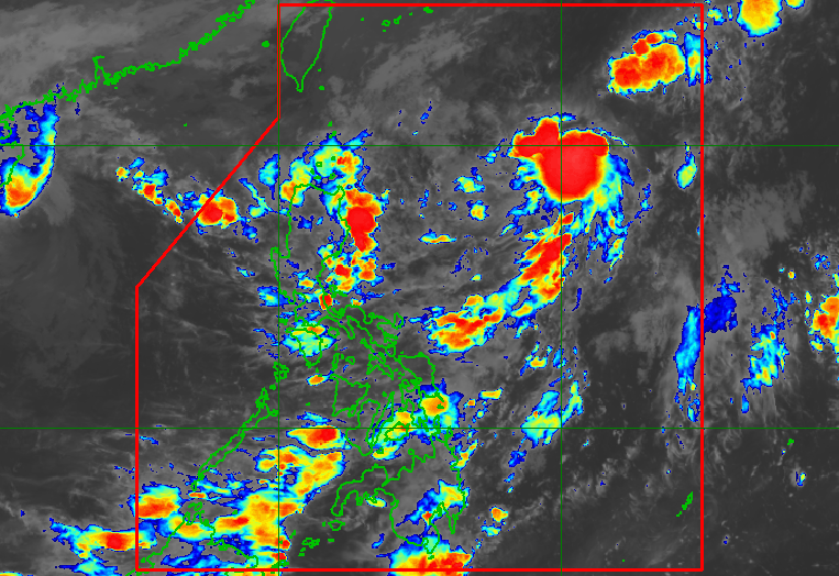
MANILA, Philippines – The low pressure area (LPA) east of extreme Northern Luzon developed into a tropical depression at 2 am on Wednesday, October 19, and was given the local name Obet.
Obet is the Philippines’ 15th tropical cyclone for 2022 and the third for October.
It was located 1,055 kilometers east of extreme Northern Luzon before dawn on Wednesday, moving north northwest at only 10 kilometers per hour (km/h).
The Philippine Atmospheric, Geophysical, and Astronomical Services Administration (PAGASA) said in a bulletin issued at 5 am that Obet is expected to head for Northern Luzon or the Luzon Strait.
It may cross extreme Northern Luzon or the northern part of mainland Northern Luzon between Friday evening, October 21, and Saturday morning, October 22.
At the moment, Obet has maximum sustained winds of 45 km/h and gustiness of up to 55 km/h.
But PAGASA said Obet may gradually intensify by mid-Friday as it approaches extreme Northern Luzon, and strengthen into a tropical storm by late Friday or early Saturday.
“Further intensification is likely once Obet reaches the West Philippine Sea,” added the weather bureau.
Rain from Obet is seen to begin on Friday evening. Here is PAGASA’s initial rainfall forecast for the tropical depression:
Friday evening, October 21, to Saturday morning, October 22
Moderate to heavy rain, with at times intense rain
- Babuyan Islands
- Ilocos Norte
- Apayao
- northern part of mainland Cagayan
Light to moderate rain, with at times heavy rain
- Batanes
- northern part of Ilocos Sur
- Abra
- Kalinga
- rest of mainland Cagayan
Saturday morning to afternoon, October 22
Light to moderate rain, with at times heavy rain
- Batanes
- Babuyan Islands
- Apayao
- northern part of Abra
- Ilocos Norte
- northern part of Ilocos Sur
The weather bureau warned that floods and landslides are possible, especially in hazard-prone areas and in areas that already received “significant” rainfall recently.
Northern Luzon is still reeling from the effects of Neneng (Nesat), which made landfall in Cagayan province’s Calayan Island as a severe tropical storm last Sunday, October 16, then left the Philippine Area of Responsibility (PAR) as a typhoon.
In addition, while there is no rain from Obet yet, the shear line will trigger scattered rain showers and thunderstorms in these areas on Wednesday:
- Batanes
- Cagayan including Babuyan Islands
- Ilocos Norte
- Apayao
The shear line is the point where the northeasterly surface windflow and the easterlies meet.
Eastern Visayas is also seeing scattered rain showers and thunderstorms on Wednesday due to the southwesterly surface windflow.

PAGASA said it may raise tropical cyclone wind signals due to Obet for some areas in Northern Luzon starting Wednesday evening or Thursday, October 20.
The highest possible wind signal is Signal No. 2 since Obet is likely to become a tropical storm.
Even before the raising of wind signals, however, the northeasterly surface windflow will already bring strong to gale-force winds to the following areas on Wednesday:
- Batanes
- Babuyan Islands
- northern part of mainland Cagayan
- northern part of Apayao
- northern part of Ilocos Norte
A gale warning was also issued at 5 am on Wednesday due to the surge of the northeasterly surface windflow. Rough to very rough seas are expected in these seaboards:
- northern and eastern seaboards of Northern Luzon (Batanes, Cagayan including Babuyan Islands, northern coast of Ilocos Norte) – waves 3.4 to 6 meters high
- western seaboard of Northern Luzon (western coast of Ilocos Norte, Ilocos Sur, La Union, Pangasinan) – waves 3.4 to 5.5 meters high
PAGASA advised fishing boats and other small vessels not to sail, and larger vessels to watch out for big waves.
The surge of the northeasterly surface windflow and Obet may also trigger moderate to rough seas, which could be risky for small vessels, in the following seaboards:
- seaboards of Central Luzon – waves 1.5 to 3.5 meters high
- western and eastern seaboards of Southern Luzon – waves 1.2 to 3 meters high
Obet may leave PAR early Sunday, October 23.
PAGASA expects 5 to 9 tropical cyclones to enter or develop inside PAR from October 2022 to March 2023. Per month, these are the weather bureau’s estimates:
- October 2022 – 2 to 4
- November 2022 – 2 or 3
- December 2022 – 1 or 2
- January 2023 – 0 or 1
- February 2023 – 0 or 1
- March 2023 – 0 or 1
– Rappler.com
Add a comment
How does this make you feel?


There are no comments yet. Add your comment to start the conversation.