SUMMARY
This is AI generated summarization, which may have errors. For context, always refer to the full article.
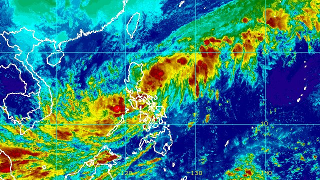
MANILA, Philippines – Tropical Depression Rosal maintained its strength while moving over the Philippine Sea, east of Quezon province, on Saturday afternoon, December 10.
In a briefing past 5 pm on Saturday, the Philippine Atmospheric, Geophysical, and Astronomical Services Administration (PAGASA) said Rosal was located 285 kilometers east of Infanta, Quezon.
The tropical depression slowed down, moving north northwest at 15 kilometers per hour from the previous 20 km/h.
It continues to have maximum sustained winds of 45 km/h and gustiness of up to 55 km/h.
Rosal is not expected to make landfall in the Philippines, as it is seen to maintain its north northwest or north direction before turning northeast over the next few days.
But the tropical depression continues to bring rain to parts of Luzon and the Visayas. PAGASA warned that floods and landslides are likely.
Saturday, December 10
Moderate to heavy rain, with at times intense rain
- Bicol
- Quezon
Moderate to heavy rain
- Mimaropa
- Western Visayas
Light to moderate rain, with at times heavy rain
- Aurora
- rest of Calabarzon
- rest of Visayas
Sunday, December 11
Light to moderate rain, with at times heavy rain
- Bicol
- Mimaropa
- Quezon
- Western Visayas
With Rosal farther from land, only the northern part of Catanduanes remains under Signal No. 1. In particular, the municipalities of Pandan, Gigmoto, Bagamanoc, Panganiban, Viga, and Caramoran are still seeing strong winds from the tropical depression.
PAGASA added that there may be occasional gusts due to the northeast monsoon or hanging amihan in the following areas:
- Batanes
- Babuyan Islands
- northern part of Cagayan
- Apayao
- northern part of Ilocos Norte

Also due to the surge of the northeast monsoon, PAGASA issued a gale warning at 5 pm on Saturday, covering these seaboards:
- northern and western seaboards of Northern Luzon (Batanes, Ilocos Norte, Ilocos Sur, La Union, Pangasinan, northern coast of Cagayan including Babuyan Islands) – rough to very rough seas, waves 2.8 to 5 meters high
- eastern seaboard of Northern Luzon (eastern coast of Cagayan) – rough to very rough seas, waves 2.8 to 4.5 meters high
The weather bureau advised fishing boats and other small vessels not to sail, and larger vessels to watch out for big waves.
The surge of the northeast monsoon and the tropical depression combined may also cause moderate to rough seas, with waves 1.2 to 3 meters high, in the seaboards of Central Luzon as well as the eastern and western seaboards of Southern Luzon. Travel may be risky for small vessels.
PAGASA said Rosal may intensify into a tropical storm over the Philippine Sea within 24 hours. But once it interacts with the northeast monsoon, it could weaken back into a tropical depression on Monday, December 12, and become a remnant low on Tuesday, December 13.
Rosal is the country’s 18th tropical cyclone for 2022 and the first for December. The weather bureau earlier said there may be one or two tropical cyclones during the month. – Rappler.com
Add a comment
How does this make you feel?


There are no comments yet. Add your comment to start the conversation.