SUMMARY
This is AI generated summarization, which may have errors. For context, always refer to the full article.
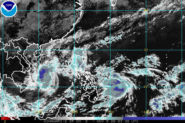
Tropical Depression Ulysses accelerated and slightly intensified over the Philippine Sea on Monday morning, November 9.
In an online briefing past 11 am on Monday, the Philippine Atmospheric, Geophysical, and Astronomical Services Administration (PAGASA) said Ulysses is already 635 kilometers east northeast of Surigao City, Surigao del Norte, or 605 kilometers east of Borongan City, Eastern Samar.
The tropical depression is moving northwest at a much faster 40 kilometers per hour (km/h), from just 15 km/h earlier on Monday.
PAGASA said Ulysses is expected to maintain its northwest direction until Tuesday morning, November 10.
Then it could turn west and head for the Bicol-Quezon area, where it is likely to make landfall on Wednesday, November 11, possibly in the afternoon or evening. Note that this may still change if Ulysses’ track and/or speed changes.
As of Monday morning, Ulysses has maximum sustained winds of 55 km/h from the previous 45 km/h and gustiness of up to 70 km/h from the previous 55 km/h.
It is forecast to strengthen further and could become a tropical storm within 24 hours, and then a severe tropical storm. It may even reach typhoon status on Wednesday before making landfall, according to PAGASA. (READ: FAST FACTS: Tropical cyclones, rainfall advisories)
For now, Ulysses has no direct impact on the country yet.
PAGASA said winds and rain from Ulysses could begin affecting parts of Eastern Visayas and Bicol on Tuesday or Wednesday.
To warn the public about strong winds ahead of time, Signal No. 1 may be raised in parts of those two regions by Monday evening or early Tuesday morning.
In the next 24 hours, Ulysses and the easterlies combined will also cause moderate to rough seas in the eastern seaboards of the Philippines. PAGASA advised small vessels to take precautionary measures, as waves could reach 1.5 to 2.5 meters high.
Ulysses could exit the Philippine Area of Responsibility (PAR) on Friday, November 13.

Meanwhile, the tail-end of a cold front is bringing moderate to heavy rain, with at times intense rain, in these northern provinces of the country on Monday:
- Cagayan including Babuyan Islands
- Isabela
- Aurora
PAGASA said residents must stay on alert for possible floods and landslides.
Ulysses is the Philippines’ 21st tropical cyclone for 2020 – already above the yearly average of 20. (READ: LIST: PAGASA’s names for tropical cyclones in 2020)
For the next 6 months, these are PAGASA’s estimates for tropical cyclones inside PAR:
- November 2020 – 1 to 3
- December 2020 – 2 or 3
- January 2021 – 0 or 1
- February 2021 – 0 or 1
- March 2021 – 0 or 1
- April 2021 – 0 or 1
Since October, La Niña has been underway, which means there is more rain than usual.
Then in November, the northeast monsoon or hanging amihan began, signaling “surges of cold temperatures.”
PAGASA warned that La Niña may enhance the northeast monsoon, which could trigger floods and landslides. – Rappler.com
Add a comment
How does this make you feel?


There are no comments yet. Add your comment to start the conversation.