SUMMARY
This is AI generated summarization, which may have errors. For context, always refer to the full article.
The weather in Mindanao is expected to begin gradually improving as Tropical Depression Vicky continues to head for Palawan. But parts of Luzon and the Visayas will still have rain mostly from the tail-end of a frontal system and the northeast monsoon or hanging amihan, along with Vicky.
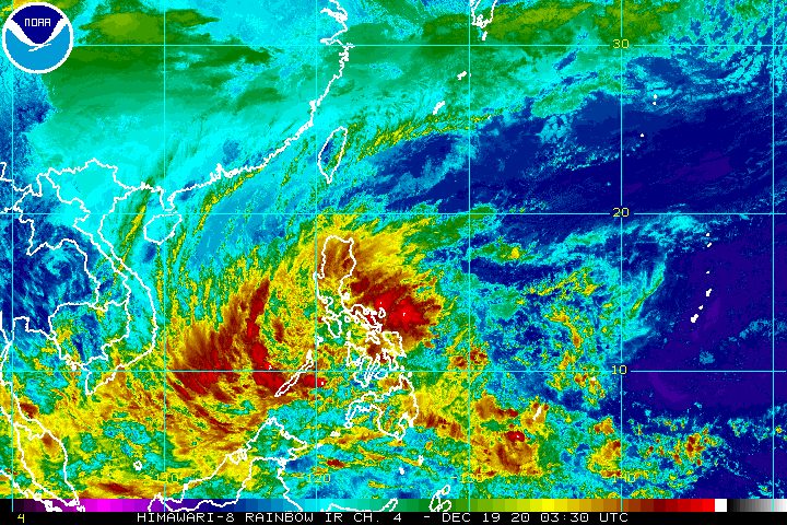
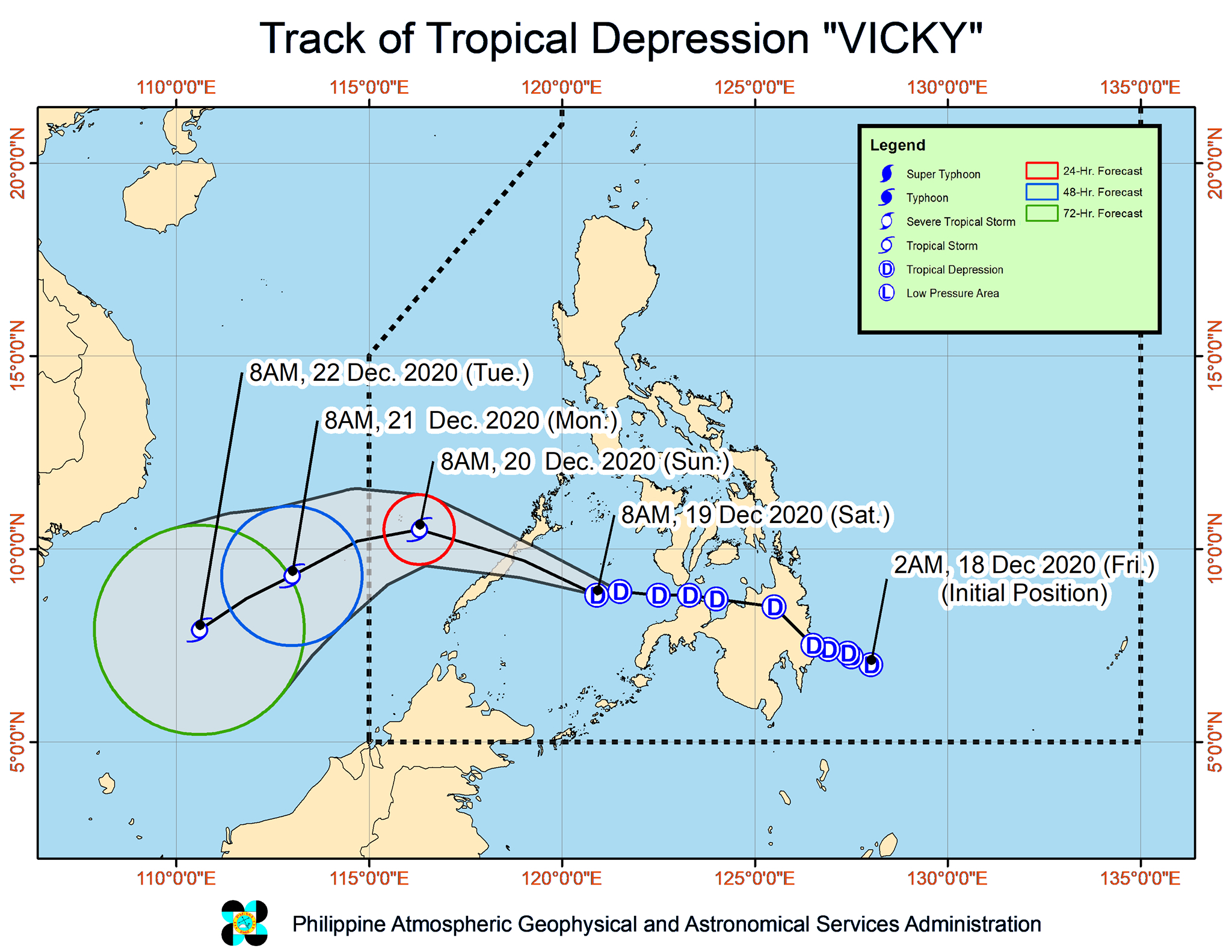
The Philippine Atmospheric, Geophysical, and Astronomical Services Administration (PAGASA) said in its 11 am bulletin on Saturday, December 19, that Vicky is now 220 kilometers east southeast of Puerto Princesa City, Palawan.
The tropical depression is moving west toward Palawan at a slightly slower 20 kilometers per hour (km/h) from the previous 25 km/h.
It is expected to make landfall in the northern or central part of Palawan on Saturday evening, then emerge over the West Philippine Sea.
The tropical depression made its 1st landfall in Baganga, Davao Oriental, at 2 pm on Friday, December 18, then crossed parts of Mindanao before emerging over the Bohol Sea and subsequently the Sulu Sea.
As of late Saturday morning, Vicky still has maximum sustained winds of 45 km/h and gustiness of up to 55 km/h. It is likely to stay a tropical depression when it hits Palawan, but it is seen to intensify into a tropical storm once it reaches the West Philippine Sea. (READ: FAST FACTS: Tropical cyclones, rainfall advisories)
Here is PAGASA’s updated rainfall forecast for the weekend:
Saturday, December 19
Moderate to heavy rain, with at times intense rain
- Calabarzon
- Bicol
- Isabela
- Aurora
- Marinduque
- northern and central parts of Palawan including Calamian, Cuyo, and Cagayancillo Islands
- Eastern Visayas
Light to moderate rain, with at times heavy rain
- rest of mainland Cagayan Valley
- rest of Central Luzon
- rest of Mimaropa
- Cordillera Administrative Region
- Metro Manila
- rest of Visayas
- Dinagat Islands
- Surigao del Norte
- Surigao del Sur
- Agusan del Norte
- Camiguin
- Misamis Oriental
Sunday, December 20
Heavy to intense rain
- Bicol
- Quezon
- Aurora
- Isabela
- Quirino
- Nueva Vizcaya
Moderate to heavy rain, with at times intense rain
- rest of mainland Cagayan Valley
- Apayao
- Kalinga
- Mountain Province
- Ifugao
- Oriental Mindoro
- Kalayaan Islands
Light to moderate rain, with at times heavy rain
- rest of Cordillera Administrative Region
- rest of Calabarzon
- rest of Mimaropa
- Metro Manila
- Bulacan
- Eastern Visayas
- Dinagat Islands
PAGASA warned that more floods and landslides could still occur.
Meanwhile, Signal No. 1 has been lifted for areas in the Visayas and Mindanao as of 11 am on Saturday.
Only the northern and central parts of Palawan (Araceli, Dumaran, Taytay, El Nido, San Vicente, Roxas, Puerto Princesa City, Aborlan, Narra, Quezon, Sofronio Española), including Calamian, Cuyo, Cagayancillo, and Kalayaan Islands, remain under Signal No. 1, which means they will experience “strong breeze to near gale conditions.”
But PAGASA noted that the surge of the northeast monsoon may also bring gusty conditions to most parts of Luzon and the Visayas, especially coastal and mountainous areas.
Sea travel remains risky due to Vicky and the surge of the northeast monsoon, too.
Rough to very rough seas (waves 2.5 to 4.5 meters high)
- entire seaboards of Northern Luzon
- seaboard of Aurora
- eastern seaboard of Quezon including Polillo Islands
- seaboard of Camarines Norte
- northern seaboard of Camarines Sur
- northern and eastern seaboards of Catanduanes
- eastern seaboard of Albay including Rapu-Rapu Islands
- eastern seaboard of Sorsogon
- northern and eastern seaboards of Northern Samar
- eastern seaboard of Eastern Samar including Homonhon Island
- eastern seaboard of Dinagat Islands
- eastern seaboard of Surigao del Norte
- seaboard of Surigao del Sur
- eastern seaboard of Davao Oriental
Moderate to rough seas (waves 2 to 4 meters high)
- coastal waters of areas under Signal No. 1
- seaboards of Agusan del Norte, Camiguin, Misamis Oriental, Lanao del Norte, and Misamis Occidental
- remaining seaboards of Luzon, Visayas, Surigao del Norte, Dinagat Islands, and Zamboanga del Norte
Vicky is expected to leave the Philippine Area of Responsibility (PAR) on Sunday afternoon or evening, December 20.
Vicky is the Philippines’ 22nd tropical cyclone for 2020 – exceeding the yearly average of 20 – and the 1st for December. (READ: LIST: PAGASA’s names for tropical cyclones in 2020)
For December 2020 and January-June 2021, these are PAGASA’s estimates for tropical cyclones inside PAR:
- December 2020 – 1 or 2
- January 2021 – 0 or 1
- February 2021 – 0 or 1
- March 2021 – 0 or 1
- April 2021 – 0 or 1
- May 2021 – 0 or 1
- June 2021 – 1 or 2
La Niña has been underway since October, causing more rain than usual in the country. – Rappler.com
Add a comment
How does this make you feel?


There are no comments yet. Add your comment to start the conversation.