SUMMARY
This is AI generated summarization, which may have errors. For context, always refer to the full article.
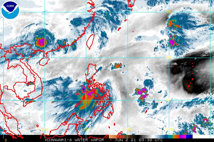
Tropical Storm Dante (Choi-wan) had made landfall five times in the Philippines as of Wednesday morning, June 2, with a sixth landfall likely.
In a briefing past 11 am on Wednesday, the Philippine Atmospheric, Geophysical, and Astronomical Services Administration (PAGASA) said Dante made landfall in the following areas:
Tuesday, June 1
- Sulat, Eastern Samar – 8:30 pm
Wednesday, June 2
- Cataingan, Masbate – 1 am
- Balud, Masbate – 3:30 am
- Romblon, Romblon – 8 am
- San Agustin, Romblon – 8:50 am
Dante was last spotted over the northwestern coastal waters of Romblon, Romblon, or 115 kilometers southeast of Calapan City, Oriental Mindoro, late Wednesday morning. It was moving northwest at the same speed of 25 kilometers per hour (km/h).
PAGASA Weather Specialist Ariel Rojas explained in the briefing that Dante’s shift toward land was influenced by a high pressure area. In initial forecasts, it appeared that Dante would spare the Philippines from landfall, though the state weather bureau did stress that the tropical storm could later move westward and hit land, which is what happened.
PAGASA said Dante may pass near Oriental Mindoro or the southwestern part of Batangas before making another landfall in Bataan on Wednesday evening. Then it could cross Zambales and Pangasinan before emerging over the West Philippine Sea on Thursday morning, June 3.
Dante maintained its strength late Wednesday morning, with maximum sustained winds of 65 km/h and gustiness of up to 90 km/h. (READ: FAST FACTS: Tropical cyclones, rainfall advisories)
PAGASA said Dante will likely maintain its strength until it makes landfall in mainland Luzon. But it could weaken into a tropical depression on Thursday after hitting mainland Luzon’s rugged terrain.
The state weather bureau updated its rainfall forecast for Dante, and again emphasized that the tropical storm may trigger floods and landslides.
Moderate to heavy rain, with at times intense rain
- Calabarzon
- Romblon
- Marinduque
- Occidental Mindoro
- Oriental Mindoro
- Zambales
- Bataan
- Aklan
- Antique
- Capiz
- Iloilo
- Guimaras
Moderate to heavy rain
- Tarlac
- Pampanga
- Bulacan
- Metro Manila
- northern part of Palawan including Calamian, Cuyo, and Cagayancillo Islands
- Negros Occidental
Light to moderate rain, with at times heavy rain
- rest of Central Luzon
- Benguet
- Nueva Vizcaya
- Quirino
- rest of Mimaropa
- Negros Oriental
- Cebu including Camotes and Bantayan Islands
Meanwhile, there are no more areas in the Visayas under Signal No. 2, but some remain under Signal No. 1. Most of the areas still under tropical cyclone wind signals as of 11 am on Wednesday are in Luzon.
Signal No. 2
Damaging gale-force winds prevailing or expected within 24 hours
- Romblon
- Marinduque
- northern and central parts of Oriental Mindoro (Roxas, Bongabong, San Teodoro, Puerto Galera, Baco, Calapan City, Naujan, Victoria, Socorro, Pola, Pinamalayan, Gloria, Bansud)
- northern and central parts of Occidental Mindoro (Sablayan, Santa Cruz, Paluan, Mamburao, Abra de Ilog, Lubang Islands)
- Batangas
- Cavite
- Bataan
- southwestern part of Bulacan (Calumpit, Bulacan, Malolos City, Paombong, Hagonoy)
- western part of Pampanga (Masantol, Macabebe, Sasmuan, Lubao, Floridablanca, Porac, Guagua, Santa Rita, Angeles City, Mabalacat City, Minalin, Bacolor)
- Zambales
- western part of Tarlac (Bamban, Capas, San Jose, Mayantoc, Camiling, Santa Ignacia, San Clemente)
- western part of Pangasinan (Bolinao, Anda, Bani, Agno, Burgos, Infanta, Dasol, Alaminos City, Mabini, Sual, Labrador, Bugallon, Aguilar, Mangatarem, Bayambang, Urbiztondo, Basista, Malasiqui, San Carlos City, Santa Barbara, Mangaldan, Dagupan City, Calasiao, Binmaley, Lingayen)
Signal No. 1
Strong winds prevailing or expected within 36 hours
- northern part of Palawan (Calamian Islands, Cuyo Islands)
- rest of Oriental Mindoro
- rest of Occidental Mindoro
- western part of Quezon (Lucena City, Tayabas City, Pagbilao, Lucban, Sariaya, Candelaria, Dolores, Tiaong, San Antonio, Padre Burgos)
- western and central parts of Laguna (Luisiana, Pagsanjan, Santa Cruz, Majayjay, Magdalena, Liliw, Nagcarlan, Pila, Victoria, Rizal, San Pablo City, Calauan, Bay, Alaminos, Los Baños, Calamba City, Cabuyao City, Santa Rosa City, Biñan City, San Pedro City)
- Metro Manila
- Rizal
- Bulacan
- rest of Pampanga
- rest of Tarlac
- western part of Nueva Ecija (Cabiao, San Antonio, Gapan City, San Isidro, San Leonardo, Jaen, Zaragoza, Licab, Guimba, Cuyapo, Nampicuan, Talugtug, Quezon, Aliaga, Santa Rosa)
- rest of Pangasinan
- southern part of Benguet (Itogon, Tuba, Sablan, Baguio City, La Trinidad, Kapangan, Tublay)
- La Union
- Aklan
- Capiz
- northern part of Antique (Valderrama, Bugasong, Laua-an, Barbaza, Tibiao, Culasi, Sebaste, Pandan, Libertad, Caluya)
- northwestern part of Iloilo (Lambunao, Calinog, Bingawan)
PAGASA said winds in areas under Signal No. 2 could bring “generally light to moderate damage to structures and vegetation,” while winds in areas under Signal No. 1 may cause “generally very light damage.”
In the next 24 hours, Dante will also continue to affect some of the country’s seaboards.
Rough to very rough seas (waves 2.5 to 4 meters high)
Travel is risky for small vessels, while “mariners without the proper experience should immediately seek safe harbor”
- seaboards of areas under Signal No. 2
- remaining seaboards of Bicol
Moderate to rough seas (waves 1.2 to 3 meters high)
Small vessels must take precautionary measures, while inexperienced mariners should avoid venturing out to sea
- seaboards of areas under Signal No. 1
- remaining seaboards of Visayas
- seaboard of Caraga
- northern seaboard of Northern Mindanao
- eastern seaboard of Davao Oriental
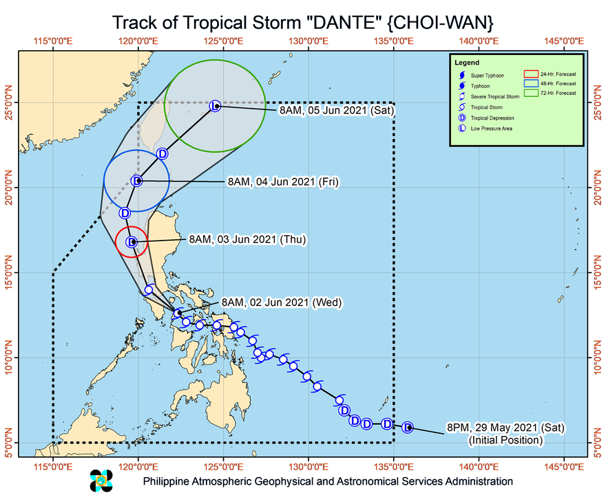
Dante is the Philippines’ fourth tropical cyclone for 2021. The country has an average of 20 tropical cyclones every year. (READ: LIST: PAGASA’s names for tropical cyclones in 2021)
For June to November, PAGASA estimates the following number of tropical cyclones inside PAR:
- June – 1 to 3
- July – 2 to 4
- August – 2 or 3
- September – 2 or 3
- October – 2 or 3
- November – 2 or 3
PAGASA said on Wednesday that the criteria for the declaration of the rainy season could be met by this weekend – Saturday, June 5, or Sunday, June 6 – or early next week, which would be the second week of June, given the rain from Dante. – Rappler.com
Add a comment
How does this make you feel?


There are no comments yet. Add your comment to start the conversation.