SUMMARY
This is AI generated summarization, which may have errors. For context, always refer to the full article.
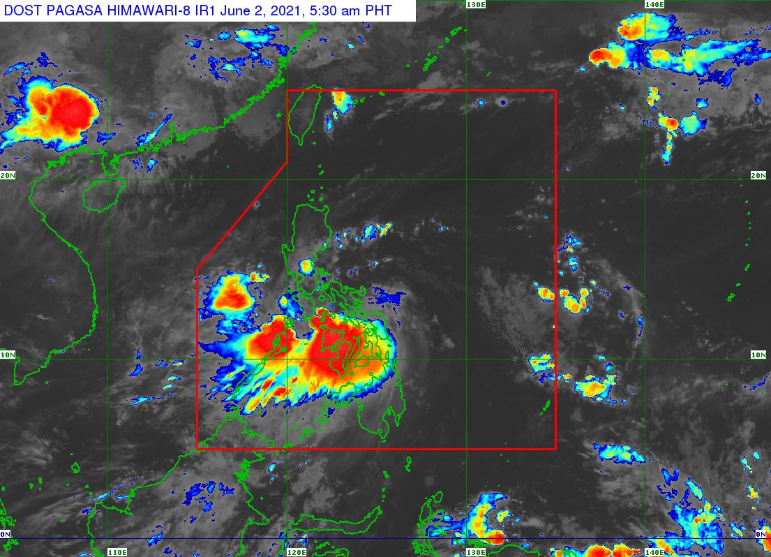
Tropical Storm Dante (Choi-wan) was moving toward Romblon before dawn on Wednesday, June 2, after making landfall twice.
Dante’s first two landfalls were in these areas:
- Sulat, Eastern Samar – 8:30 pm on Tuesday, June 1
- Cataingan, Masbate – 1 am on Wednesday, June 2
The Philippine Atmospheric, Geophysical, and Astronomical Services Administration (PAGASA) said in its 5 am bulletin on Wednesday that Dante was over the western coastal waters of Balud, Masbate.
The tropical storm accelerated in the early hours of Wednesday, and its track shifted even more to the west or over landmass. It is moving west at 25 kilometers per hour (km/h).
Dante still has maximum sustained winds of 65 km/h, while its gustiness is up to 90 km/h. (READ: FAST FACTS: Tropical cyclones, rainfall advisories)
With the tropical storm’s westward movement, more areas were placed under a tropical cyclone wind signal, including Metro Manila. Here is the complete list as of 5 am on Wednesday:
Signal No. 2
Damaging gale-force winds prevailing or expected within 24 hours
- southern part of Quezon (Tagkawayan, Sariaya, Lucena City, Pagbilao, Padre Burgos, Agdangan, Unisan, Atimonan, Plaridel, Gumaca, Pitogo, Lopez, Calauag, Guinayangan, Catanauan, General Luna, Macalelon, Buenavista, San Narciso, San Andres, San Francisco, Mulanay, Quezon, Perez, Alabat)
- extreme southeastern part of Batangas (San Juan, Lobo)
- Marinduque
- central part of Oriental Mindoro (Calapan City, Naujan, Pola, Victoria, Socorro, Pinamalayan, Gloria, Bansud, Bongabong, Roxas)
- Romblon
- Masbate
- western part of Camarines Norte (Jose Panganiban, Labo, Paracale, Capalonga, Santa Elena)
- western part of Camarines Sur (Del Gallego, Ragay, Lupi, Sipocot, Libmanan, Pasacao, Pamplona, San Fernando)
- extreme northern part of Capiz (Roxas City, Pilar, Ivisan, Panay, Sapi-an)
- northern part of Aklan (Batan, New Washington, Kalibo, Numancia, Nabas, Ibajay, Tangalan, Makato, Malay)
- extreme northeastern part of Iloilo (Balasan, Carles, Estancia, Batad)
Signal No. 1
Strong winds prevailing or expected within 36 hours
- Abra
- Kalinga
- Mountain Province
- Ifugao
- Benguet
- Ilocos Sur
- La Union
- eastern part of Pangasinan (San Fabian, Mangaldan, Santa Barbara, Malasiqui, Basista, Bayambang, Bautista, Alcala, Santo Tomas, Rosales, Umingan, Balungao, Urdaneta City, Asingan, Villasis, Santa Maria, Natividad, San Quintin, Tayug, San Nicolas, San Manuel, Binalonan, Laoac, Manaoag, Mapandan, San Jacinto, Pozorrubio, Sison, Dagupan City, Calasiao, San Carlos City, Urbiztondo, Mangatarem)
- southern part of Isabela (San Mateo, Alicia, Echague, Angadanan, Jones, San Agustin, San Isidro, Santiago City, Ramon, Cordon)
- Nueva Vizcaya
- Quirino
- Aurora
- Nueva Ecija
- Tarlac
- Pampanga
- Bulacan
- Metro Manila
- Rizal
- Laguna
- Cavite
- rest of Batangas
- rest of Quezon including Polillo Islands
- rest of Camarines Norte
- rest of Camarines Sur
- Catanduanes
- Albay
- Sorsogon
- rest of Oriental Mindoro
- Occidental Mindoro
- western part of Northern Samar
- western part of Samar (Calbayog City, Santa Margarita, Gandara, San Jorge, Tarangnan, Pagsanghan, Catbalogan City, Jiabong, Motiong, San Sebastian, Calbiga, Pinabacdao, Santa Rita, Villareal, Talalora, Daram, Zumarraga, Tagapul-an, Almagro, Santo Niño)
- Biliran
- northern part of Leyte (Babatngon, San Miguel, Barugo, Tunga, Carigara, Kananga, Matag-ob, Palompon, Isabel, Merida, Ormoc City, Jaro, Tacloban City, Alangalang, Capoocan, Leyte, Villaba, Tabango, Calubian, San Isidro)
- northern and central parts of Cebu (Pinamungahan, Toledo City, Cebu City, Minglanilla, Naga City, Talisay City, Cordova, Lapu-Lapu City, Consolacion, Mandaue City, Liloan, Compostela, Balamban, Danao City, Asturias, Tuburan, Carmen, Catmon, Borbon, Sogod, Tabuelan, San Remigio, Tabogon, Bogo City, Medellin, Daanbantayan) including Bantayan and Camotes Islands
- northern part of Negros Occidental (Moises Padilla, Hinigaran, La Castellana, San Enrique, La Carlota City, Valladolid, Pontevedra, Pulupandan, Bago City, San Carlos City, Salvador Benedicto, Murcia, Bacolod City, Talisay City, Silay City, Enrique B. Magalona, Victorias City, Manapla, Sagay City, Cadiz City, Escalante City, Toboso, Calatrava)
- extreme northern part of Negros Oriental (Canlaon City, Vallehermoso)
- Guimaras
- rest of Iloilo
- rest of Capiz
- rest of Aklan
- Antique
PAGASA said winds in areas under Signal No. 2 could bring “generally light to moderate damage to structures and vegetation,” while winds in areas under Signal No. 1 may cause “generally very light damage.”
Rain from Dante will also continue in parts of Luzon and the Visayas, which may cause more floods and landslides. Below is the rainfall forecast covering Wednesday until early Thursday morning, June 3.
Moderate to heavy rain, with at times intense rain
- Romblon
- Oriental Mindoro
- Marinduque
- Iloilo
- Capiz
- Aklan
- Antique
- Guimaras
- Negros Occidental
- northern part of Negros Oriental
- northern and central parts of Cebu including Bantayan Island
Moderate to heavy rain
- Calabarzon
- Occidental Mindoro
- Masbate
- northern part of Palawan including Calamian and Cuyo Islands
- rest of Negros Oriental
- rest of Cebu
Light to moderate rain, with at times heavy rain
- Metro Manila
- Central Luzon
- Pangasinan
- Benguet
- rest of Mimaropa
- rest of Bicol
- rest of Visayas
Travel remains dangerous in coastal waters affected by Dante.
Rough to very rough seas (waves 2.5 to 4 meters high)
Travel is risky for small vessels, while “mariners without the proper experience should immediately seek safe harbor”
- seaboards of areas under Signal No. 2
- remaining seaboards of Bicol
Moderate to rough seas (waves 1.2 to 3 meters high)
Small vessels must take precautionary measures, while inexperienced mariners should avoid venturing out to sea
- seaboards of areas under Signal No. 1, except Catanduanes
- seaboards of Calamian and Cuyo Islands
- remaining seaboards of Visayas
- seaboards of Caraga
- eastern seaboard of Davao Oriental
- northern seaboard of Northern Mindanao
PAGASA said at 5 am on Wednesday that Dante will pass near or in the vicinity of Romblon and Marinduque in the next 12 hours, before turning toward the southern Quezon-Batangas area, where it could make its third landfall in the afternoon or evening.
Then it would cross mainland Luzon until Thursday afternoon.
“However, given the recent southwestward shift in the track forecasts,
there is a possibility that this storm may come onshore over Oriental Mindoro after passing Romblon,” added PAGASA.
Dante is also likely to maintain its strength until it makes landfall over mainland Luzon, according to the state weather bureau. But once it hits mainland Luzon’s rugged terrain, it could weaken into a tropical depression on Wednesday afternoon or evening.
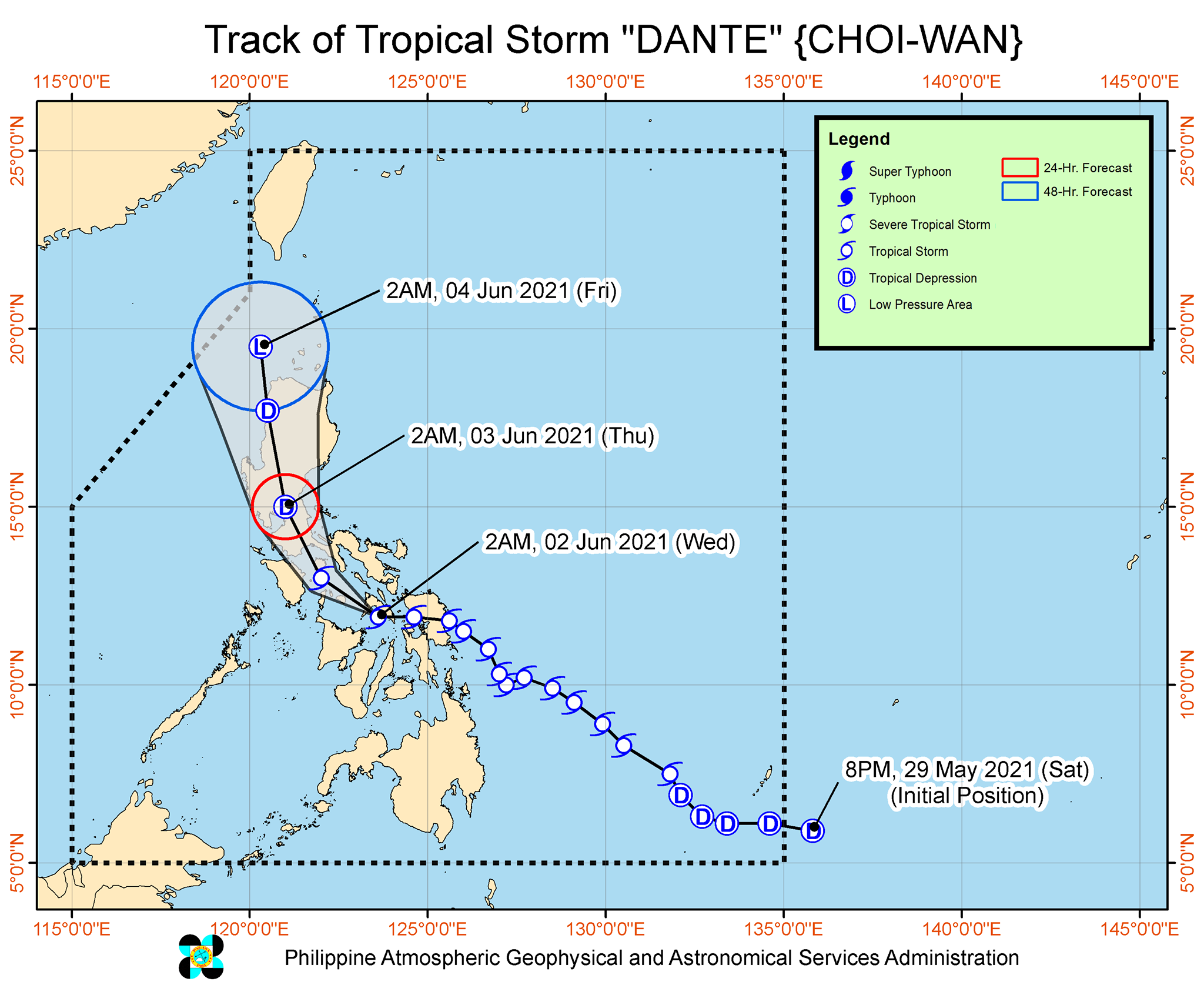
Dante is the Philippines’ fourth tropical cyclone for 2021. The country has an average of 20 tropical cyclones every year. (READ: LIST: PAGASA’s names for tropical cyclones in 2021)
For June to November, PAGASA estimates the following number of tropical cyclones inside PAR:
- June – 1 to 3
- July – 2 to 4
- August – 2 or 3
- September – 2 or 3
- October – 2 or 3
- November – 2 or 3
The state weather bureau is expected to declare the onset of the rainy season and the southwest monsoon or hanging habagat in the first half of June. – Rappler.com
Add a comment
How does this make you feel?


There are no comments yet. Add your comment to start the conversation.